Drew Plantation

Location Map for Drew

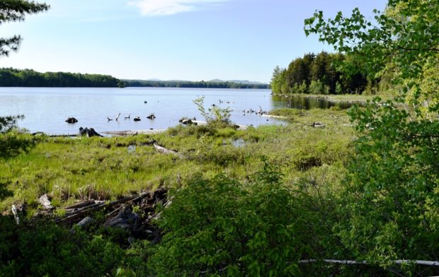
Its eastern portion is dominated by the Mattawamkeag River System Wildlife Management Area. Recreational opportunities include boating, canoeing, and wildlife viewing for eagles, osprey, deer, moose and water birds. The 6,800 plus acre parcel includes Mud Pond. In 1921 Drew was incorporated as a town, but in the depths of the Great Depression it reverted to a plantation.

Durham

Durham Community School on the Royalsborough Road (2013)

The 1835 Union Church was a community meeting house, then in 1922, the Town Office, and recently home of the Durham Historical Society. The early 20th century religious movement known as the Sandfordites, after their leader Frank W. Sandford, built their 1897 temple “Shiloh” here. Runaround Pond offers a pleasant canoe trip through water lilies and bird life. See video and photos.

Dyer Brook

Southern Aroostook Community School (2014) @

Dyer Brook, incorporated in 1891, so named for the stream that flows through it and into the Mattawamkeag River, is in the heart of potato country. See photos. This sparsely populated rural town has no paved roads, other than U.S. Route 2. An extensive bog occupies the middle of the township.

Eagle Lake

Eagle Lake in Eagle Lake (2018)

settled 1840’s by Acadian-French and Irish immigrants, it was named for the many eagles at the Lake by a Major Strickland during the Aroostook War. Eagle Lake spawns the Fish River, which empties into the St. John River at Fort Kent. See photos. It is the birthplace and residence of former Maine House Speaker John L. Martin.

East Machias

in Washington County, incorporated 1826. Benjamin Foster built a house here in 1765 and served in the Revolutionary War. Washington Academy, a private boarding school serving grades 9-12, was established in 1792 and is one of the oldest academies in Maine. See photos.

East Millinocket

Truly a company town, as is Millinocket, its incorporation followed Great Northern’s development of the paper mill and ground wood mill in 1906. Once a source of well-paid employment, the mill has been under economic pressure, a partial cause of population loss of over 3 % during the 1970-2010 period. It is just west of Medway off I-95 in Aroostook County.

Eastbrook

Sign: Town Line, Entering Eastbrook from Waltham (2003)

in Hancock County, incorporated 1837, Settled in 1800, an early settler built the first house and established its first mill. In 1886 Eastbrook had four mills – two sawmills, one producing staves, and one manufacturing shingles. It still has several historically significant buildings. See photos. Lyle Frost Wildlife Management Area offers canoeing; wildlife to be seen: eagles, deer and water birds.

Easton

In the 1970s Easton was the site of a failed attempt to establish a sugar beet refinery to diversify dependence on the potato economy. The McCain Foods, U.S.A. facility and the J. M. Huber Corporation’s Engineered Woods plant provide local employment. Easton, in Aroostook County, incorporated in 1865.

Eastport

Friar Roads Channel from the Waterfront in Eastport (2013)

is on Moose Island at the end of a peninsular surrounded by Cobscook Bay and Passamaquoddy Bay. See video and photos. Visited by European fishermen and traders in the 1600’s, the area was settled in 1772. A proposed oil refinery was rejected based on concerns about oil spills and environmental threats. Once a fish canning center (the first sardine cannery in the U.S. opened in 1875), the city struggles against its isolated location. The historic downtown has undergone substantial restoration.

Eddington

sign: "Katahdin Scout Reservation, Camp Roosevelt," on Route 46 in East Eddington (2004)

in Penobscot County, settled 1780 and incorporated 1811, has frontage on two major ponds, Chemo and Davis and hosts Katahdin Scout Reservation, known as Camp Roosevelt. Eddington village has been known as Eddington Bend for the sharp curve in the Penobscot River.

Edgecomb

Overlooking the Sheepscot River and the Narrows at the entrance to Wiscasset Harbor, Fort Edgecomb’s tower has a 360 degree view of the water and countryside. See photos. Settlers arrived in 1744; the town incorporated in 1774. Population has more than doubling, during the decades 1970-2010.

Edinburg

Island in the Penobscot River Near Edinburg (2005)

in Penobscot County, settled in 1827, incorporated 1835 is bound on the east by the Penobscot River and lies opposite the entrance of the Passadumkeag River. The river, attractions of rural life, and the proximity of the University of Maine and the City of Bangor, may be forces contributing to recent development in the community. See photos.

Eliot

Country Living (2012)

in York County, settled in the 1630s, on the east side of the Piscataqua River dividing Maine from New Hampshire, is a growing residential community serving Kittery and Portsmouth. See photos. Its population expanded by almost 12% in the 1990-2000 decade. Eliot was home to Maine’s first Quaker Meetinghouse built in 1776.

Ellsworth

Settled in 1763, it has relied on lumbering, shipbuilding, and industry to support its economy. The classic Grand Theater has been saved as an active movie and performance space. See photos. At the confluence of seven highway routes, the city is a shopping center for the area and summer tourism. The Col. John Black Mansion, a modified Georgian design, was home to the land agent for William Bingham.

Embden

Embden Pond Boat Launch and Short Pier (2018)

The first white people arrived in the 1770’s, making settlements along the Kennebec River. Embden Pond, in the shadow of Dunbar Hill, dominates the northwest portion of the town. The shoreline is dotted with many cottages and is active in the summer with swimming, boating, and water skiing. See photos. The town has shown consistent population growth in each of the four decades 1970-2010.

Enfield

Panoramic Mountain View from Enfield (2014)

Year Population 1970 1,148 1980 1,397 1990 1,476 2000 1,616 2010 1,607 Geographic Data N. Latitude 45:15:56 W. Longitude 68:35:39 Maine House District 142 Maine Senate District 5 Congress District 2 Area sq. mi. (total) 33.2 Area sq. mi. (land) 27.9 Population/sq.mi. (land) 57.6 County: Penobscot Total=land+water; Land=land only [EN-field] is a town in Penobscot…

Eustis

Bigelow Range from Eustis Ridge Road in Eustis (2012)

In 1775 the area had been the scene of Benedict Arnold’s march to Quebec. He was accompanied by Col. Timothy Bigelow, who returned to the area and for whom Bigelow Mountain is named. Eustis village in the north of the township, is on the North Branch of the Dead River and is the smaller of the two villages, the other being Stratton.

Exeter

Crop Spray Irrigator at Exeter Corners (2014)

Uncharacteristic for most Maine towns, Exeter has neither a lake, pond or mountain of note. Maine combined Routes 11 and 43 zigs and zags in a generally east-west direction through the town. The economy is a mix between agriculture and work in the Bangor area service industries.