 N44° 41' 12.53\" W68° 17' 39.27\"")
Town Line, Entering Eastbrook from Waltham (2003) @

Location Map for Eastbrook
| Year | Population |
|---|---|
| 1970 | 188 |
| 1980 | 262 |
| 1990 | 289 |
| 2000 | 370 |
| 2010 | 429 |
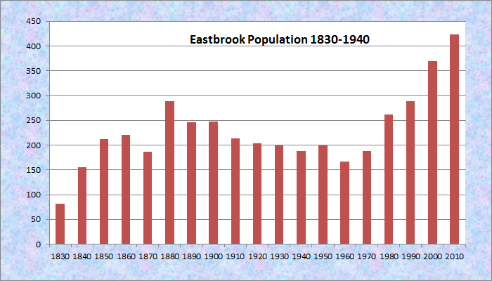
Population Trend 1830-2010
| Geographic Data | |
|---|---|
| N. Latitude | 44:41:29 |
| W. Longitude | 68:13:53 |
| Maine House | District 137 |
| Maine Senate | District 7 |
| Congress | District 2 |
| Area sq. mi. | (total) 37.6 |
| Area sq. mi. | (land) 33.3 |
| Population/sq.mi. | (land) 12.7 |
County: Hancock
Total=land+water; Land=land only |
|
[EAST-brook] is a town in Hancock County, incorporated on February 8, 1837 from township T15. In 1872 it annexed land from Waltham. It probably derives its name from the fact that Timber Brook, located in the northwest corner of the town, feeds the East Branch of the Union River.
 N44° 40' 41.03\" W68° 15' 56.77\"")
Town House & Library Interior (2013) @
 N44° 40' 40.79\" W68° 15' 55.89\"")
1881 Town House and Library (2013) @
Settled in 1800, one of its first settlers, Joseph Parsons, built the first house and established its first mill. In 1886 Eastbrook had four mills – two sawmills, one producing staves, and one manufacturing shingles. In 1880, its population was 289, the same as in 1990, though the town has posted consistent gains over the past forty years.
 N44° 40' 36.24\" W68° 15' 56.46\"")
Building Near the Grange (’13) @
 N44° 40' 36.24\" W68° 15' 56.94\"")
Eastbrook Grange Hall (2013) @
The town is northeast of Ellsworth and is served by Maine Route 200, which runs from Waltham south through Eastbrook and further south in Hancock County to Sullivan.
 N44° 39' 4.27\" W68° 15' 43.17\"")
Eastbrook Variety on Route 200 near the Franklin Town Line (2013) @
Eastbrook Village is in the eastern portion of the township on Route 200 near Scammon Pond. The grange, 1880 town house, veterans memorial, and Baptist church are all in the village.
 N44° 40' 40.39\" W68° 15' 55.24\"")
Veterans Memorial (2013) @
Four substantial ponds are clustered in the south: Abrams, Molasses, Scammon and Webb.
The area around Scammon Pond is subject to the Maine Department of Inland and Fisheries and Wildlife’s 1,160 acre Lyle Frost Wildlife Management Area. Canoeing is permitted; wildlife likely to be seen include eagles, deer, and water birds.
Form of Government: Town Meeting-Select Board.
 N44° 40' 37.16\" W68° 15' 57.60\"")
Volunteer Fire Dept. (2013) @
 N44° 41' 7.42\" W68° 17' 15.93\"")
Cave Hill School (2013) @
 N44° 40' 46.84\" W68° 15' 59.12\"")
Community Center (2013) @
Additional resources
Butler, Josephine. “Town of Eastbrook Hundred Years Old.” 1937, Sept. 15. (Cataloger Note: Mounted newspaper clipping from the Ellsworth American Sept. 15, 1937. “Historical notes gleaned by Mrs. Josephine Butler and read at the centennial program Saturday, August 28, 1937.” [Maine State Library]
Carter, Bruce. Oblivion & Dead Relatives Downeast. 1996. Downeast Graphics and Printing.
“Lyle Frost (Scammon Pond) WMA.” http://maine.gov/IFW/wildlife/management/wma/region_c/lylefrost.htm (accessed November 13, 2011)
*Maine. Historic Preservation Commission. Augusta, Me. Additional text and photos at National Register of Historic Places: http://pdfhost.focus.nps.gov/docs/nrhp/text/78000163.PDF and http://pdfhost.focus.nps.gov/docs/nrhp/photos/78000163.PDF
 N44° 40' 38.53\" W68° 15' 55.91\"")
Eastbrook Baptist Church and Town House (2013) @
National Register of Historic Places – Listings
Eastbrook Baptist Church and Eastbrook Town House
[Maine Route 200.] The 1860 Eastbrook Baptist Church and the Eastbrook Town House are within fifty feet of one another. They are interesting architecturally, demonstrating a particular style (Greek Revival) in a remote region long after its popularity had waned.
When the Town House [see photo above] was built in 1881, it was with the intent of complementing its neighbor in style. The result was a Greek Revival building at least twenty years after this style had flourished. The Town House is presently being used as the town library.*
 N44° 39' 17.55\" W68° 15' 45.59\"")
Distant Mountains from Route 200 near the Franklin Town Line (2013) @