
Location Map for Drew
| Year | Population |
|---|---|
| 1970 | 32 |
| 1980 | 57 |
| 1990 | 43 |
| 2000 | 57 |
| 2010 | 46 |
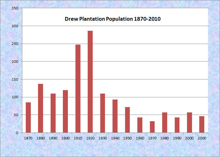
Population Trend 1870-2010
| Geographic Data | |
|---|---|
| N. Latitude | 45:37:34 |
| W. Longitude | 68:07:34 |
| Maine House | District 141 |
| Maine Senate | District 2 |
| Congress | District 2 |
| Area sq. mi. | (total) 38.8 |
| Area sq. mi. | (land) 37.6 |
| Population/sq.mi. | (land) 1.2 |
County: Penobscot
Total=land+water; Land=land only |
|
[DRU] is a plantation in Penobscot County, formerly township 7, range 4, North of Bingham’s Penobscot Purchase. It was organized on September 8, 1856, and that was reconfirmed by the Legislature on January 25, 1868. With a population of 137 in 1880, it supported two schoolhouses.
On April 5, 1921 Drew was incorporated as a town, but in the depths of the Great Depression it surrendered its status and reverted to a plantation, as it remains today.
Settled in 1825, it is in the easternmost area of Penobscot County. The Mattawamkeag River, running south from Wytopitlock in Reed Plantation to Kingman, winds through the town and its substantial bogs and wetlands.
The eastern portion of the township is dominated by the Mattawamkeag River System Wildlife Management Area, confined by railroad tracks to the northwest and Route 171 to the east. The 6,800 plus acre parcel, which includes Mud Pond, is managed by the Maine Department of Inland Fisheries and Wildlife. Recreational opportunities include boating, canoeing, and wildlife viewing for eagles, osprey, deer, moose and water birds.
Maine Route 171 passes through Drew, connecting Prentiss village in the township to the south, and Reed village to the north in Reed Plantation.
Form of Government: Assessors-Annual Meeting.
Additional resources
Parsons, Eleanor C. A Town Called Drew & Beyond. Rockport, MA. Sandy Bay Historical Society and Museums. 2003.