Dragonflies

Female Twelve-spot Skimmer Dragon Fly

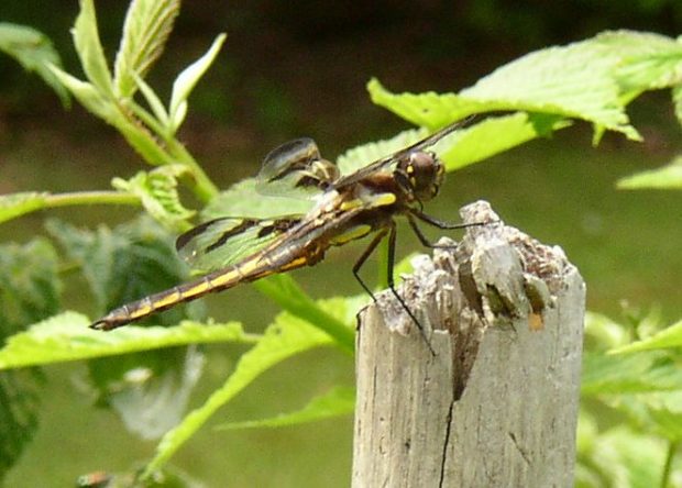
Dragonflies and Damselflies General Description Dragonflies and damselflies are scientifically classified under the order Odonata. These medium to large insects have body lengths ranging from just over half an inch to just under five inches. They are often seen flying rapidly over streams and lakes, or through gardens at dusk, often following regular flight paths…

Jim Pond Township

This Franklin County township contains a section of the Dead River’s North Branch, along with several ponds, the largest of which is Jim Pond. The smaller Greenbush Pond is more accessible, but with a limited fishery. Route 27 follows the River on its journey to Eustis where it merges with the South Branch to create…

Dead River

The Dead River is one of the longest and most storied waterways in Maine. Its North Branch flows south from the Lower Pond in Chain of Ponds, Through Alder Stream Township and Jim Pond Township. The South Branch flows north from Saddleback Lake in Rangely through Dallas Plantation, Lang Township and Coplin Plantation.    …

Insects, Leaf-footed

Western Conifer Seed Bug (2017)

The Western Conifer Seed Bug is a type of leaf-footed bug, about 3/4 inch from head to tail, that feeds on seeds of trees, especially pine. It is not a destructive pest in the home, but is a nuisance. It finds its way into homes during the end of summer and early fall looking for a place…

Brookings, Wilmot W.

Wilmot W. Brookings (1830-1905) was born in Woolwich October 23, 1830. After being admitted to the bar, the new lawyer moved to Sioux Falls in what was to become the Dakota Territory in 1861 (which included today’s North and South Dakota, and much of Wyoming and Montana), and then the state of South Dakota in…

Logging in Maine

Hunt Sawmill in Jefferson (2012)

The cutting and moving of logs destined for lumber or paper was a tough, manual effort until the second half of the 20th century. Here is an eyewitness assessment by Louise Dickenson Rich of logging camp life in the 1940’s near Middle Dam in western Maine. I also had to learn to differentiate between a…

Kibby Township

Access from Route 27 (2017)

In western most Maine and Franklin County, the Township (also known as T1 R6 WBKP) has no village and virtually no population. Its major economic resource is Kibby Ridge on Kibby Mountain. Logging the forested township is also an economic asset. Maine Route 27 in Chain of Ponds Township provides access to the network of…

Eagle Lake Township

Not to be confused with the town of Eagle Lake  in Aroostook County, Eagle Lake Township lies to the southwest in Piscataquis County. It too has frontage on another waterbody named Eagle Lake and includes part of the Allagash Wilderness Waterway and a small portion of Chamberlain Lake. A narrow stretch of Maine Public Reserved…

T22 MD Township

sign: Entering TWP 22 on Route 9

                                          Entering Township 22 on Route 9 A small community in Hancock County, the township’s only improved road, in its northeastern corner, is a portion of Route 9, (“The Airline“). Rocky Pond lies at the center…

Coburn Gore

Approaching U.S. Inspection Station (2017)

This is a small unorganized township in Franklin County on the border with Canada. It has a very small village with few houses and one store. Logging trucks abound, both in the village and those traveling through from Canada, many with lumber. Without mountains, it does have three water bodies: Arnold Pond, Crosby Pond, and…

Freeport Historic Register

House on Upper Mast Landing in the Harraseeket Historic District (2017)

National Register of Historic Places – Freeport    Mallett, E. B., Office Building [Mill Street] E.B. Mallett Office Building (2016) Perhaps more than anyone, Edmund Buxton Mallett, Jr. (1853-1923) shaped the town’s character. In 1883 he moved from Pownal to launch his empire. Between 1884 and 1892, he built and operated two shoe factories, a…

Parmachenee Township

Location Map for Parmachenee Township

This township is on the New Hampshire border in northwestern Maine. The name, according to Brian McCauley, is “Abenaki for ‘across the usual path.’ Legend says it was the name of an Indian Chief’s daughter.” The Magalloway River runs southward through it and through the 900+ acre Parmachenee Lake, which extends south into Lynchtown Township.…

Lynchtown Township

Location Map for Lynchtown Township

The Oxford County Township, in northwestern Maine on the New Hampshire border, is just south of Parmachenee Township. It includes and  a small north portion of Aziscohos Lake and the bulk of Parmachenee Lake.  That lake was home to the Parmachenee Club. The Club was formed in 1890 by a group of mostly New York…

Fruits

Pick Your Own Tray with strawberries (2017)

Berries Strawberries Strawberries are a high value crop in Maine agriculture with net profit potential of $6,000 or more per acre. The number of farms raising strawberries and the acreage dedicated to them increased substantially in recent years, with more demand for locally grown fresh fruit. Strawberries are the most widely grown small fruit crop…

Katahdin Woods and Waters National Monument

Hiking, Biking, Horseback Trail in Katahdin Woods and Waters (2017)

In August 2016, President Barak Obama designated this area a National Monument.  It was offered to the United States government by the Roxanne Quimby Foundation, which has established a substantial endowment with the National Park Foundation to support the administration the monument. Katahdin Woods and Waters Recreation Area, east of Baxter State Park, contains about…