Woodstock

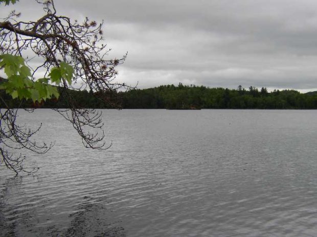
Not the site of the 1960’s rock concert (that was New York), Woodstock’s major village is Bryant Pond, named from the adjacent water body. The Pond outlet is the source of the Little Androscoggin River. See photos. South Woodstock is home to the small South Woodstock Meetinghouse and is the site of an old mill pond and mill on Andrews Brook.

Woodland

Long view in Woodland on the Colby Siding Road (2003)

With little in the way of a central village, the town lies west of Caribou served by Maine Routes 161 and 228. See photos. Unable to find enough land in New Sweden, members of the Swedish Colony were granted 100 acre lots in Woodland. This northern community, in the heart of potato and forest product country, is not to be confused with the village of Woodland in the town of Baileyville.

Wood, John

(1813-1864) a U.S. Representative was born in Minisink, New York on November 17, 1813. He attended the common schools. Wood engaged in railroad construction in New Jersey, moved to Portland in 1846, and was one of the contractors in the construction of the Atlantic & St. Lawrence Railroad. He also engaged in banking. A member…

Laughlin, Gail

(1868-1952) was a prominent lawyer, legislator, and women’s rights advocate. She was born on May 7, 1868 as Abbie Hill Laughlin, in Robbinston. She graduated from Portland High School in 1886, receiving the Brown Medal for the highest grades. Laughlin worked as a bookkeeper for four years before saving enough money to attend Wellesley College.…

Wiscasset

is on U.S. Route 1 and the Sheepscot River. See photos and videos. With many historic structures, the town was host to “The Greenland Expedition of 1925,” which included explorers Richard Byrd and Donald McDonald. Since 1918 Camp Chewonki has been offering outdoor programs here. The town was once best known for its Maine Yankee Atomic Power plant.

Winthrop

Maranacook Lake in Winthrop (2013)

n addition to its recreational attractions, the town is a suburban community serving both the Augusta and Lewiston-Auburn areas. See photos. Winthrop is the birthplace in 1899 of Delphia Louis “Del” Bissonette, who played for the Brooklyn Dodgers.

Winterville Plantation

Location Map for Winterville Plantation

Located about 25 miles south of Fort Kent on Maine Route 11, the area is an attraction for fishermen and hunters. St. Froid Lake (see photo) dominates the plantation by running virtually its whole length from north to south, a watery barrier separating the eastern from the western land portions. Quimby village is on the eastern shore of the lake; Winterville village is on Route 11, about two miles east of the lake.

Winterport

Marsh Bay on the Penobscot River just South of Winterport Village (2003)

Winterport is primarily a rural community with its land area extending ten miles westward from the river. See photos. An attraction along Route 139 among the farms and woods is the Winterport Dragway, featuring auto drag races with specialty vehicles and “street” vehicles. In recent years a marina has expanded and an export business has been established on the river. A dockside freezer operation enabled the storage and shipping of commodities such as fish and chicken.

Winn

Location Map for Winn

Winn village is on U.S. Route 2 between Lincoln and Mattawamkeag on the east bank of the Penobscot River. See photos. During the 19th century, International Paper Company harvested wood to supply its pulp and paper mills. Winn is an agricultural community slowly losing its small population as are many northern Maine towns.

Wingate, Joseph Ferdinand

(1786-??) a U.S. Representative, was born in Haverhill, Essex County, Massachusetts on June 29, 1786. He received a limited schooling. Wingate engaged in the retail business in Bath and became a member of the Massachusetts House of Representatives in 1818 and 1819. A collector of customs at the port of Bath 1820-1824, he was elected…

Windsor

Location Map for Windsor

Windsor’s village center clusters around the town office, the fire station, the Post Office, and Hussey’s General Store at the intersection of Maine Routes 32 and 105. The Windsor Fair attracts crowds each fall to this once agricultural, but increasingly residential, community east of Augusta.

Windham

The main village, North Windham, lies adjacent to Sebago Lake and on the shore of Little Sebago Lake at the junction of U.S. Route 302 and Maine Routes 35 and 115. See photos. While Route 302 is a long commercial strip, an old meeting house is adjacent to the Windham Union Church. Young adult offenders are held at the Maine Correctional Center in South Windham.

Wilton

Location Map for Wilton

Located on the shore of Wilson Pond, the main village lies at the intersection of U.S. Route 2 and Maine Routes 4 and 156.. See photos. George H. Bass began making boots for farmers in 1876. For more than 100 years, the G. H. Bass company made footwear in Wilton.

Willimantic

Location Map for Willimantic

Located on the western end of Sebec Lake, the town offers many camping and fishing opportunities. Packard Landing was the location of Packard’s Camps in the late 19th and early 20th centuries. Maine Route 150 runs north from Guilford and terminates at the village of Sebec Lake, not to be confused with the town of Sebec at the far eastern end of the Lake.

Willis, Nathaniel P.

Selected works American Scenery, Or, Land, Lake And River Illustrations Of Transatlantic Nature, Vols. I and II (1840) Canadian Scenery Illustrated (1842) The Convalescent (1859) Dashes At Life With A Free Pencil (1845) Famous Persons And Places (1854) Fugitive Poetry (1829) Fun-Jottings, Or, Laughs I Have Taken A Pen To (1853) Health Trip To The…

Williams, Reuel

(1783-1862) a U.S. Senator, was born in Hallowell on June 2, 1783 and attended Hallowell Academy. He studied law, was admitted to the bar in 1804, and began his practice in Augusta. Wiliams was a member of the State legislature 1812-1829, 1832, and 1848, and served as commissioner of public buildings in 1831. A presidential…