")

Location Map for Woodland
| Year | Population |
|---|---|
| 1970 | 1,218 |
| 1980 | 1,369 |
| 1990 | 1,402 |
| 2000 | 1,403 |
| 2010 | 1,213 |
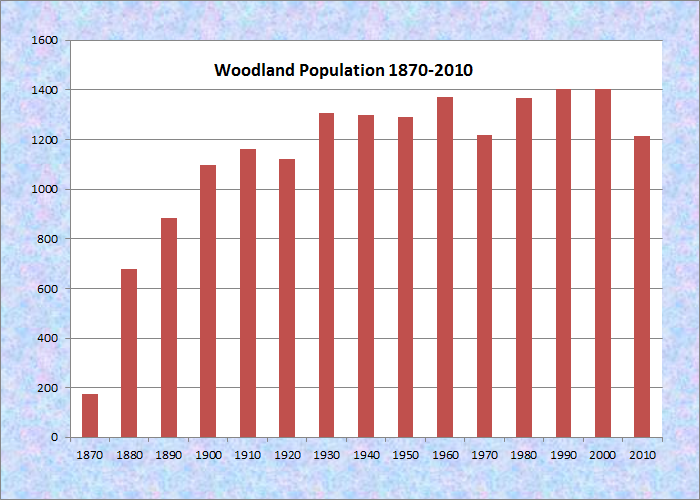
Population Trend 1870-2010
| Geographic Data | |
|---|---|
| N. Latitude | 46:52:40 |
| W. Longitude | 68:06:40 |
| Maine House | District 146 |
| Maine Senate | District 1 |
| Congress | District 2 |
| Area sq. mi. | (total) 35.3 |
| Area sq. mi. | (land) 35.3 |
| Population/sq.mi. | (land) 34.4 |
County: Aroostook
Total=land+water; Land=land only |
|
")
Long view in Woodland on the Colby Siding Road (2003)
[WOOD-lnd] is a town in Aroostook County settled originally in 1860 and organized as a plantation on April 25, 1861, with its organization confirmed by the State Legislature in 1878. On March 5, 1880 it became a town.
")
Lagerstrom House, Woodland Historical Society (2003)
As early as the 1850’s wood was being cleared from the area. Ephraim Barnum arrived with his family in 1860. Its northern part was settled by Swedes in 1872. Unable to find enough land in New Sweden, members of the Swedish Colony were granted 100 acre lots in Woodland and became the largest group in the town.
The Lagerstrom House, built about 1896, was donated to the Woodland Historical Society by Priscilla Lagerstrom Walther and John Lagerstrom in memory of their Swedish grandparents, Carl and Emma Lagerstrom who had lived there in the early 20th century.
")
Entering Woodland from Perham on Route 228 (2015)
 N46° 52' 56.28\" W68° 7' 36.60\"")
Horses near Large Barn on Route 228 (2015) @
 N46° 53' 7.07\" W68° 8' 29.78\"")
Recreational Trail off Route 228 (2015) @
 N46° 53' 8.22\" W68° 7' 31.43\"")
Panoramic View on the Morse Road (2015) @
In the 1880’s, the Gazetteer of Maine has these observations about the town:
The soil is very fertile. The yield of wheat is about 400 bushels to the acre, and of potatoes about 400 bushels. . . . Agriculture is the almost exclusive occupation of the people. The few frame houses in the town are in good repair, but the log houses have a decayed look. There is one shingle-mill capable of manufacturing about 20,000 shingles per day. A stave-mill here has a capacity of 2,000 staves per day. The nearest railway is in Caribou, six miles from the centre of Woodland.
 N46° 52' 21.48\" W68° 4' 16.50\"")
Snowman School Museum (2015) @
At the time, Woodland had five public schoolhouses supported by a population of 679 in 1880. The Woodland Historical Society’s Snowman School Museum, on Route 228 at Thibodeau Road, recalls the towns early history.
")
Former Railroad Siding on the Now Defunct Aroostook Valley Railroad (2003)
This northern community, in the heart of potato and forest product country, is not to be confused with the village of Woodland in the Washington County town of Baileyville.
With little in the way of a central village, the town lies west of Caribou served by Maine Routes 161, 164 and 228. Woodland village in the north is on Route 228; the village of Carson in the south is on the Carson Road off Route 164. (photos 2015)
")
Carson Road in Carson Village
")
Carson Road in Carson Village
 N46° 50' 41.64\" W68° 8' 22.62\"")
Carson Rd Pentecostal Church @
Form of Government: Town Meeting-Select Board-Administrative Assistant.
Additional resources
Chadbourne, Ava Harriet. Maine Place Names and The Peopling of its Towns.
Varney, George J. A Gazetteer of the State of Maine. 1886. pp. 602-603.