 N46° 45' 58.68\" W68° 11' 36.84\"")
North Side of the Aroostook River in South Wade (2015) @

Location Map for Wade
| Year | Population |
|---|---|
| 1970 | 255 |
| 1980 | 285 |
| 1990 | 243 |
| 2000 | 250 |
| 2010 | 283 |
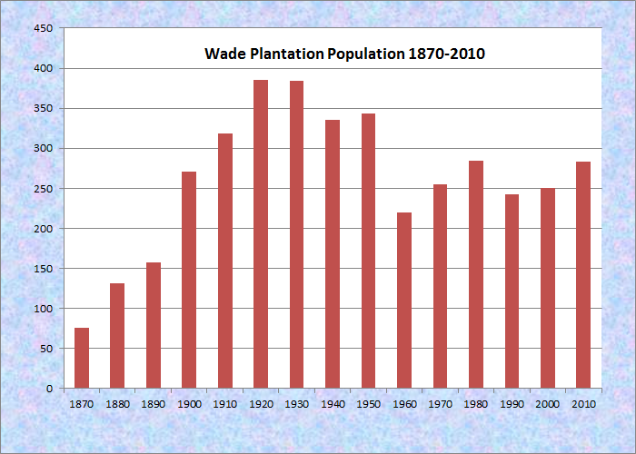
Population Trend 1870-2010
| Geographic Data | |
|---|---|
| N. Latitude | 46:47:38 |
| W. Longitude | 68:14:58 |
| Maine House | District 146 |
| Maine Senate | District 1 |
| Congress | District 2 |
| Area sq. mi. | (total) 36.4 |
| Area sq. mi. | (land) 36.1 |
| Population/sq.mi. | (land) 7.8 |
County: Aroostook
Total=land+water; Land=land only |
|
[WAAD] is a small rural town in Aroostook County, settled in 1846.
Wade was organized for election purposes in 1861, organized as a plantation in 1874 and reorganized in 1895.
It was incorporated as a town on March 4, 1913 from Wade Plantation, once township T13 R4 WELS.
Once known as Garden Creek Plantation and Dunntown, Wade is just northwest of Presque Isle on the Aroostook River.
In 1886, the Gazetteer of Maine reported no mills or manufacturing, but it had these observations:
There is good, loamy soil, yielding abundantly in wheat, oats and potatoes, which are the crops receiving most attention. The inhabitants are at present engaged almost exclusively in agriculture. There is here a sulphur spring, said to be the best in the State. . . . It has a public library of 75 volumes. There are already three public schoolhouses, valued at $300. The population in 1870 was 76.
 N46° 45' 29.76\" W68° 13' 23.16\"")
North Side of the Aroostook River in South Wade (2015) @
The Aroostook River in Wade is part of one of Maine’s “Focus Areas of Statewide Ecological Significance.”
According to a report of the Natural Areas Program,
“The combination of natural communities, rare plants and rare animals in such close proximity to one another make this section of the Aroostook River an important area for focusing conservation attention. . . .
Upstream, the Wade ledges site near the Wade-Washburn border is quite rich in rare plant species . . . .”
The South Wade Road begins in Washburn and runs southwest through Wade south of the Aroostook River. It ends just before the River exits south to Castle Hill.
Gardner Creek Road travels a similar course on the north side of the River.
North Wade is a small village in the extreme northeast corner of the township. The North Wade Road runs 2.5 miles west of the Perham Road (Route 228), then ends.

Town Line sign on Route 228 in North Wade @
 N46° 49' 47.22\" W68° 10' 50.04\"")
Dunntown Advent Christian Church, North Wade (2015) @
 N46° 49' 47.28\" W68° 10' 49.98\"")
North Wade Village on Route 228 (2015) @
Form of Government: Town Meeting-Select Board.
Additional resources
Maine. Department of Agriculture, Conservation and Forestry. Natural Areas Program. “Aroostook River- Washburn to Presque Isle.” http://www.maine.gov/dacf/mnap/focusarea/aroostook_river_washburn_presqueisle_focus_area.pdf (accessed April 8, 2014)
Tasker, William J. The Pioneer Homes of Washburn, Maine : Including Perham, Wade and Crouseville. Caribou, Me. Monkey Publishing. c2006. [University of Maine, Raymond H. Fogler Library, Special Collections; Maine State Library; University of Maine at Presque Isle, Library and Learning Resource Center]