 N46° 50' 37.68\" W68° 13' 36.18\"")
Panoramic View from the north side of Mouse Island Road (2015) @

Location Map for Perham
| Year | Population |
|---|---|
| 1970 | 436 |
| 1980 | 437 |
| 1990 | 395 |
| 2000 | 434 |
| 2010 | 386 |
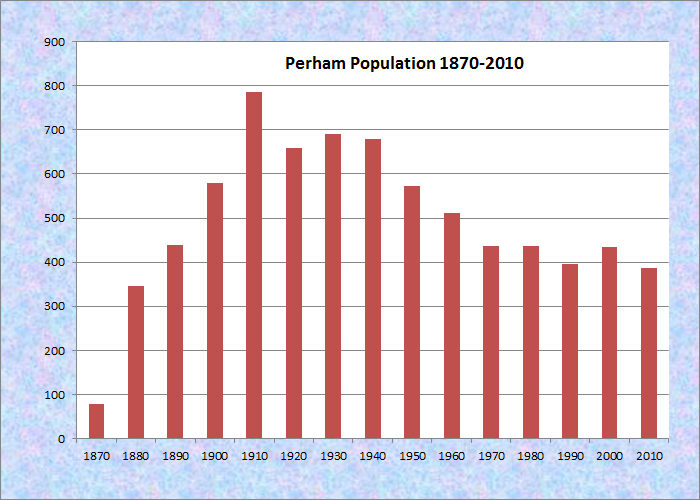
Population Trend 1870-2010
| Geographic Data | |
|---|---|
| N. Latitude | 46:53:00 |
| W. Longitude | 68:15:21 |
| Maine House | District 146 |
| Maine Senate | District 1 |
| Congress | District 2 |
| Area sq. mi. | (total) 36.7 |
| Area sq. mi. | (land) 36.5 |
| Population/sq.mi. | (land) 10.6 |
County: Aroostook
Total=land+water; Land=land only |
|
 N46° 50' 12.00\" W68° 11' 23.28\"")
Entering from Wade (2015) @
[PER-uhm] is a town in Aroostook County, settled in 1856, organized “for election purposes” in 1867. It was incorporated as a town on March 26, 1897 from Perham Plantation. The town was named for Sidney Perham of Paris who was elected governor in 1871.
Perham village lies in the southeast near Salmon Brook, which flows from the lake through the township.
 N46° 50' 37.98\" W68° 11' 49.20\"")
The Village and Perham Baptist Church (2015) @
")
The Baptist Church in the (2015) Village
 N46° 50' 38.94\" W68° 11' 51.90\"")
Village Post Office (2015) @

Mouse Isl. Rd Splits West @
Moose Island Road reaches directly west from the village center, turning into a dirt road after 2.5 miles and ending in another 2 miles. A large farm complex and an abandoned farmhouse are the few structures on the road.
 N46° 50' 37.32\" W68° 13' 42.06\"")
Farmhouse and Barn on the Mouse Isl. Road (2015) @
 N46° 50' 36.96\" W68° 13' 50.88\"")
Farmhouse and Barn on the Mouse Isl. Road (2015) @
 N46° 50' 36.96\" W68° 13' 50.88\"")
Unoccupied House on the Mouse Isl. Road (2015) @
 N46° 50' 36.96\" W68° 13' 50.88\"")
Long View south from the Mouse Isl. Road (2015) @
 N46° 50' 37.68\" W68° 13' 36.18\"")
Panoramic View from the north side of Mouse Island Road (2015) @
Back on Route 228 north of the village, the road leads to more farms and eventually to the Woodland Center Road, which takes a sharp right turn toward Woodland.
The appearance of a wind turbine, a modern house and a new barn just before the Woodland line is a surprising contrast to the traditional farming landscape.
 N46° 50' 41.82\" W68° 11' 47.88\"")
Route 228 in central Perham (2015) @
 N46° 51' 25.92\" W68° 12' 28.02\"")
Pentecostals of Perham on Route 228 (2015) @
 N46° 51' 40.26\" W68° 12' 30.90\"")
Large House and Barn on Route 228 (2015) @
 N46° 51' 44.70\" W68° 12' 30.54\"")
Large Barn on Route 228 (2015) @
 N46° 52' 8.58\" W68° 12' 36.00\"")
Potato Field on Route 228 in Perham @
 in Perham (2015)")
House, Barn, Wind Turbine on Woodland Center Road (2015)
According to the Northern Aroostook Region Management Plan,
Logging and farming have significantly shaped the history and character of this area. Portions of the Unit now forested show evidence of its once being cleared for pasture. A dam created for logging once existed on the outlet of Salmon Brook Lake [but] no longer exists.
The northern portion of the town is dominated by a section of Maine Public Reserved Land, some of which encompasses the Salmon Brook Lake. A 1,055-acre Ecological Reserve surrounds the lake and wetlands.
 N46° 50' 34.86\" W68° 11' 40.44\"")
Town Garage (2015) @
The Bangor and Aroostook Trail is a 59-mile multi-use trail located in the towns of Perham, Caribou, and other area towns. The trail, formerly a Bangor and Aroostook Railroad corridor, passes along the western side of Salmon Brook Lake Bog in northern Perham.
Clifford G. McIntire, a U.S. Representative in the 20th century, was born in Perham.
 Congressional Medal of Honor winner:
EDWARD C. DAHLGREN
Form of Government: Town Meeting-Select Board-Administrator.
Additional resources [click images to enlarge and clarify]
Maine. Department of Conservation. Northern Aroostook Region Management Plan. June 2007. http://www.maine.gov/doc/parks/programs/planning/northern/plan.pdf (accessed February 17, 1012)
Tasker, William J. The Pioneer Homes of Washburn, Maine: Including Perham, Wade and Crouseville. Photography by Robin Drost. Caribou. Me. Monkey Publishing. c2006.
Town of Perham: People, Places, Past, Present; 1867, 1897, 1997. Perham Ladies Group. Perham, Me. The Perham Ladies Group. 1997. [University of Maine at Presque Isle, Library and Learning Resource Center; Maine State Library]
Wyman, Flora McIntire. My Childhood in the Great Forest. Arranged and edited by Florence Wyman Calkins. Acton, Mass.? The Editor. 1979.