
Location Map for Freeport
| Year | Population |
|---|---|
| 1970 | 4,781 |
| 1980 | 5,863 |
| 1990 | 6,905 |
| 2000 | 7,800 |
| 2010 | 7,879 |
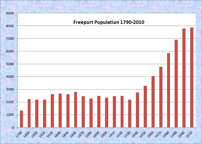
Population Trend 1790-2010
| Geographic Data | |
|---|---|
| N. Latitude | 43:50:40 |
| W. Longitude | 70:06:02 |
| Maine House | District 48 |
| Maine Senate | District 24 |
| Congress | District 1 |
| Area sq. mi. | (total) 46.5 |
| Area sq. mi. | (land) 34.7 |
| Population/sqmi | (land) 227.1 |
County: Cumberland
Total=land+water; Land=land only |
|
Clipper Ship Built Here
- Quickstep-1853
")
Large Indian, U.S. Rt 1 (2001)
[FREE-port] is a rapidly growing town in Cumberland County, incorporated on February 14, 1789 from part of North Yarmouth and Prout’s Gore. On four subsequent occasions it ceded land to Brunswick, once to Pownal.
")
Thomas Means Club (2010)
")
Flying Point Cemetery (2010)
Before its incorporation, the Means Massacre at Flying Point in 1756 was one of many Indian attacks.
A former one-room schoolhouse on Flying Point Road is now home to the Thomas Means Club, named for one of the victims of the massacre. The Flying Point Cemetery is the resting place for many early settlers.
Freeport’s passenger rail service resumed in 2012 after a long absence. Currently the town relies on the northern most terminus in of AMTRAK’s service in Downeaster in Brunswick. The Boston trains have frequently been sold-out since service began and reyling on the recent return in Brunswick.
The town was named, according to some, for Sir Andrew Freeport, a character in Addison’s Spectator Papers. Appropriately for its later development, Freeport represented the merchant class.
During the War of 1812, Edward Soule, from Freeport but living in Parkman, was captured three times by the British, and spent fourteen months in Dartmoor prison. Although Freeport voted against Maine independence from Massachusetts at least five times, the unsubstantiated legend that the Jamison-Codman Tavern played a role in the movement continues.
South Freeport on the Harraseeket River was a center for ship building. Its Freeport-built vessels Lafayette and Blen were captured and burned by Confederate raiders during the Civil War. South Freeport was the main settlement until a stage route was instituted in the 1790s along what is now Main Street. Gradually, Freeport Corners as it was known, became the primary business district, spurred on by the arrival of the railroad in 1849 and an electric railway in 1902.
Arctic explorer Donald B. MacMillan lived in Freeport and graduated from Freeport High School. The town was also home to a young John Gould, later an author, humorist, and newspaper editor. He developed a close friendship with outdoor outfitter company founder L.L. Bean.
")
Outlet Stores. Main Street (2010)
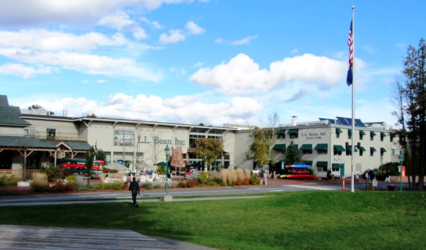
Currently, it is a popular center of “outlet” stores, including the legendary L. L. Bean, which has a virtual campus of retail buildings in addition to its own outlet store. Freeport also hosts Bean’s corporate headquarters and catalog order site.
")
Belcher House (2015)
The huge 1828-1829 Federal Style Belcher House anchors the southern end of the Main Street Historic District (see below). The house and barn, built by Freeport lawyer Richard Belcher, initially were threatened with demolition but were renovated to serve as retail space by gutting the interior. The exterior was preserved; its garden became a parking lot.
The Maine Idyll Motor Court, as its quaint name suggests, was established in the 1930’s. Its sign has been seen by millions of travelers from U.S. Route 1 in the early days, and from Interstate 95 in recent times. Freeport is a stop on the Downeaster AMTRAK train with service between Brunswick and Boston.
The town hosts two nature preserves. Mast Landing Sanctuary, on Upper Mast Landing Road, is operated by the Maine Audubon Society and has self-guiding nature trails through fields, woods, salt marsh, and along streams with beavers in residence. The remains of and old mill dam recalls its earlier human residents.
")
Mill Ruins at Mast Landing Sanctuary (2005)
")
Meadow at Mast Landing Sanctuary (2005)
Wolf’s Neck Woods State Park also has self-guiding nature trails through picturesque woods fronting the Harraseeket River and Casco Bay, along with a picnic area and an active osprey nest on a small island just offshore.
")
Entrance to Wolf’s Neck Woods State Park (2018)
")
")
")
")
Casco Bay and Casco Bay Trail (2018)
")
Casco Bay from the Casco Bay Trail (2018)

Sign for Maine Idyll Motor Court
")
Town Landing in South Freeport (2001)
Form of Government: Council-Manager
More Videos!
Additional resources
Cummings, Ronald. Freeport, Maine Trolleys, 1902-1929 : Most Unique in the U.S.A. During 1920’s. Freeport, Me. Village Press. 199-?
**Anderson, Patricia M. and Sally Rand. “Main Street Historic Survey, Freeport, Maine: September 1997-August 1998.” The Dash: Newsletter of the Freeport Historical Society. Winter 1999. http://freeporthistoricalsociety.org/wp-content/uploads/2014/12/1999-Winter.pdf (accessed 3/9/15)
Freeport, Maine: Its Progress and Prosperity. Portland, Me. Portland Board of Trade. 1904. [University of Maine, Fogler Library, Special Collections]
Rand, Sally W. “Freeport’s Role In Maine’s Statehood.” Freeport Historical Society. http://freeporthistoricalsociety.org/freeport-history/freeports-role-in-maines-statehood (accessed February 19, 2013)
Sullivan, Lynn Katherine. The Economic Transformation and Historical Invention in 20th century Freeport, Maine. Thesis (M.Ed.)–University of Southern Maine, 2002. [University of Southern Maine (Portland). The Albert Brenner Glickman Family Library.]
Thurston, Florence G. Three Centuries of Freeport, Maine. Freeport, Me. 1940. (Portland, Me. Southworth-Anthoensen Press)
Wiley, Sarah. The Freeport Bicentennial Commemorative Journal. Freeport, Me. Printed by Village Press. 1989.
National Register of Historic Places – Listings