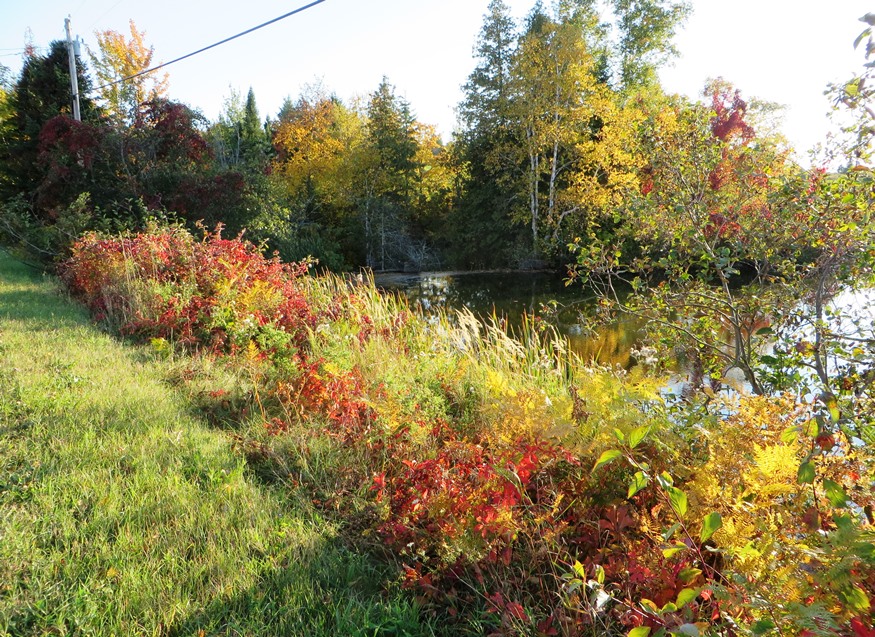
Fall Foliage at Dudley Brook on the West Chapman Road (2014)

Location Map For Chapman
| Year | Population |
|---|---|
| 1970 | 328 |
| 1980 | 406 |
| 1990 | 422 |
| 2000 | 465 |
| 2010 | 468 |
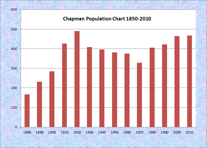
Population Trend 1880-2010
| Geographic Data | |
|---|---|
| N. Latitude | 46:37:53 |
| W. Longitude | 68:06:38 |
| Maine House | District 146 |
| Maine Senate | District 2 |
| Congress | District 2 |
| Area sq. mi. | (total) 38.9 |
| Area sq. mi. | (land) 38.4 |
| Population/sq.mi. | (land) 12.2 |
County: Aroostook
Total=land+water; Land=land only |
|
")
[CHAP-mn] a town in Aroostook County, incorporated on March 11, 1915 from Chapman Plantation. It was first organized as a plantation on April 27, 1874, with an 1870 population of 40. By 1880 it was 166.
Chapman village is at the extreme northwest of the township on the West Chapman Road.
 N46° 39' 27.61\" W68° 9' 45.22\"")
Fall Foliage at Dudley Brook ..
 N46° 39' 29.20\" W68° 9' 45.14\"")
… on West Chapman Road (2014)
In 2013 “A Comprehensive Plan for the Towns of Mapleton, Castle Hill and Chapman,” was adopted by each town. A brief history, condensed here, was included in the Plan:
Situated in the middle of eastern Aroostook County amidst vast timber and rolling hills was Township 11, Range 3. Cyrus Chapman, an early surveyor, surveyed the township marking all four corner posts with his full name. From that time forward, the town was known as “Chapman.” Chapman began seeing the first settlers in the late 1860’s and early 1870’s. Chapman Plantation was organized in 1874
Most men worked in the woods cutting timber and hauling logs. Logs were transported by teams of horses through an opening in adjacent Swanback woods to the Presque Isle Stream to float to the mill. In the winter, this long trek often had to be shoveled in order for the horses to get through the snow.
The early 1900’s showed a steady migration to Chapman. The railroad came to Chapman in 1910. Today, there is a snowmobile club picnic area along the now abandoned tracks. The railroad increased access to Squapan (now Scopan) Lake, which allowed timber harvesting of the area. Crews, teams with heavy loads were often seen crossing the ice in dangerous winter conditions. Teams and loads were known to have gone through the ice.
In 1946-47, the town voted to close the school houses. Chapman joined the school district which included Mapleton, Castle Hill, Wade, Washburn and Perham.
The following years Chapman showed slow growth. The fine timber continued to be a lucrative natural resource. Beaulieu’s Mill was built in 1960. Residential construction was dormant until the mobile home age. From 1969-1979, the number of mobile homes more than doubled. Chapman was an area affordable to live and in close proximity to the job market. In 1974, the town voted to change to Town Manager form of government. Mapleton, Castle Hill and Chapman shared that position. [click on images to clarify and enlarge]
“Farm Food Transportation” on Town Hall Road (2014)
")
Town Hall Road in Chapman (2014)
")
Houses on Grendell Road, east of Town Hall Road (2014)
The 100+ year old wood frame structure at 94 Town Hall Road is the former one room Grendell School house, remodeled to add kitchen facilities, indoor plumbing, and an oil furnace. The building is primarily used for town meetings, snowmobile club meetings, and fund raising dinners.
")
Old School/Town Hall, now a Snowmobile Club facility (2014)
")
“Chapman Ridge Runners Snowmobile Club” (2014)
")
Building near the Snowmobile Club (2014)
Castle Hill’s woodlot is made up of approximately 7,500 acres and is both a revenue source and recreational asset for residents. A Woodlot Management Program is designed to promote woodlot improvements and maintain wildlife habitat. Harvest operations are on-going and the town is responsible for the maintenance of access roads and updating and maintaining maps and lot lines.
Haystack Historical Society’s School House Museum in Mapleton serves Castle Hill, Chapman and Mapleton, provides tours by appointment and its vision of the Old Mill School.
Chapman has followed the regional trends of declining acreages of active farmland, and declining numbers of operational farming units.
")
House and Buildings on the West Chapman Road (2014)
")
Farmhouse and Barn on the West Chapman Road (2014)
")
Houses on the West Chapman Road (2014)
Southwest of Presque Isle, the town is served by no major highway, though its population has been growing steadily in an area where population loss is the norm. It is accessible primarily from Route 163 in Mapleton, and by the Chapman Road from Presque Isle.
Form of Government: Town Meeting-Select Board-Manager.
Additional resources
Burden, Rachel Foss Higgins. Amazing Mazie: Mariam Olive Greenlaw McGlauflin, 1846-1945. Presque Isle, Me. Print Works. 2007. (Additional title: An Aroostook Pioneer from Charlotte, Washington County to Mapleton, Spragueville, Presque Isle, Chapman.)
Northern Maine Development Commission. A Comprehensive Plan for the Towns of Mapleton, Castle Hill and Chapman. Caribou, Me. 2009. http://www.maine.gov/dacf/municipalplanning/comp_plans/Mapleton-Castle_Hill-Chapman_2012.pdf (accessed March 4, 2014)