")
Cottages along Wells Beach (2012)

Location Map for Wells
| Year | Population |
|---|---|
| 1970 | 4,448 |
| 1980 | 6,719 |
| 1990 | 7,778 |
| 2000 | 9,400 |
| 2010 | 9,589 |
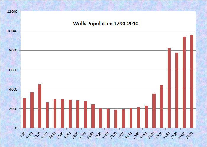
Population Trend 1790-2010
| Geographic Data | |
|---|---|
| N. Latitude | 43:19:39 |
| W. Longitude | 70:37:34 |
| Maine House | Dist 4,7 |
| Maine Senate | District 34 |
| Congress | District 1 |
| Area sq. mi. | (total) 58.2 |
| Area sq. mi. | (land) 57.6 |
| Population/sqmi | (land) 166.5 |
County: York
Total=land+water; Land=land only |
|
")
Roadside Stand, Wells (1945) George French photo
[WELLZ] is located in York County, and was the third town established in Maine, incorporated on July 5, 1653 from a portion of the town of Webbannet. It has swapped land with Kennebunk in two transactions: 1820 and 1868. Ogunquit, and its early history, was once part of Wells.
Named by Sir Fernando Gorges for the English city of the same name, Wells was first settled in 1641. Massachusetts, having recently acquired Maine as a province, established in 1699 a Court of General Sessions of the Peace to handle all criminal complaints to meet twice a year at Wells and twice a year at York.
It has the distinction of being the only Maine town not conquered during the various French and Indian wars 1650 to 1730.
 N43° 19′ 18.6″ W70° 35′ 26.9″")
Wells Town Office (2012) @
 N43° 19′ 21.1″ W70° 34′ 53.7″")
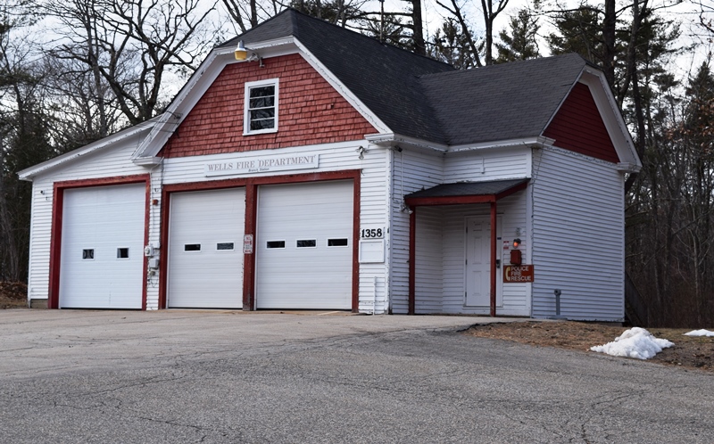
Fire Department (2012) @
Rural Fire Station on the Branch Road (2020)
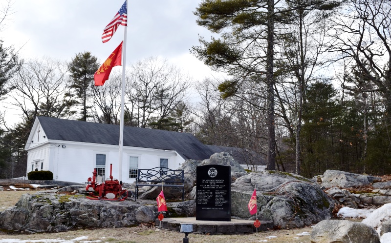
Memorial to founders in 1945 of the Fire Association (2020)
According to the 2004 draft of its Comprehensive Plan, [edited and condensed]:
By 1641 Edward Littlefield established a permanent home, sawmill and gristmill at the site of the Webhannet River Falls. Reverend John Wheelright soon followed and in 1642 established a church and a small settlement.
The early settlers took advantage of the numerous rivers and brooks in the area by establishing mills that served clusters of nearby farms. Stores, blacksmith shops and post offices soon grew up nearby. Farmsteads, orchards and pasture lands, hay fields and wood lots were soon developed.
Just as the Town began to grow the Indian Wars (first the King Phillip’s War and then the French & Indian War) that lasted from approximately 1675 to the mid-1700s took a toll on the residents and stunted its growth.
Following the American Revolution and the War of 1812, Wells prospered from fishing and shipping of timber to Europe and imported products the West Indies and Europe.
Although overland travel was difficult, by 1825 there were eight taverns serving stage coach travelers. The railroad arrived in the 1840s providing local employment and accessibility from all directions. The rails soon displaced much of shipping freight business.
 During this period people from outside the town began to discover Wells’ beaches during the summer. (Wells Nature Preserve photo)
By late in the century the “tourism” business began to materialize. The trend expanded during the 20th century and today Wells has a significant tourist economy.
In 2004 the town estimated its peak summer population at about 39,000, including seasonal homes, lodging houses, and recreational vehicle parks. That is four times the resident population.
")
Wells Elementary (2012)
")
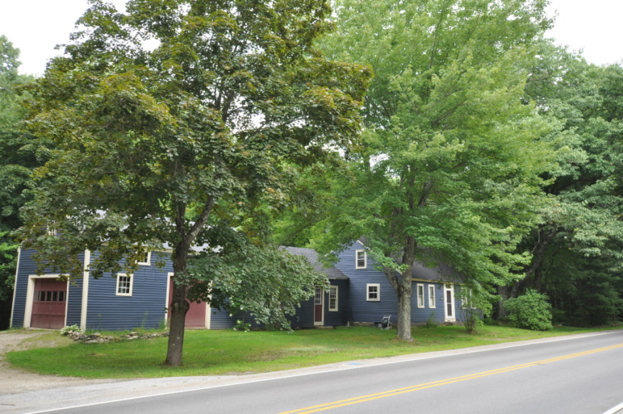
Houses near the Beach (’12)
 N43° 19' 11.32\" W70° 34' 55.51\"")
Wells Junior High (2012) @
 N43° 18′ 53.2″ W70° 33′ 38.3″")
Houses at the Beach (2012) @
 N43° 18′ 53.3″ W70° 33′ 38.3″")
Beach Wide View (2012) @
 N43° 18′ 7.0″ W70° 33′ 58.9″")
Wells Beach (2012) @
The resort community, was part of Wells until 1980. Wells is also home to the York County Community College. The town is also the birthplace of 19th century U.S. Representative John F. Scammon.
The First Congregational Church of Wells (see National Register below) is now home to the Historical Society of Wells and Ogunquit. It is located on Main Street, which is U.S. Route 1.
The village of Moody features a fine shoreline known as Moody Beach. While it was considered a public space for many years, in 1989 a court ruled that it is the private property of abutting landowners. It is not available to the public for swimming or beach use. Other beaches are accessible in the area.
While the Main Street is a commercial strip, it hosts a few community facilities, including the Junior High, the Historical Society, and others, such as those below.
 N43° 16' 43.66\" W70° 35' 42.66\"")
Post Office for Moody Village (2013) @
 N43° 16' 33.03\" W70° 35' 48.91\"")
Scout Hall in an Old Schoolhouse (2013) @
 N43° 19' 10.86\" W70° 34' 54.85\"")
Veterans Memorial in Ocean View Cemetery (2013) @
The Rachel Carson National Wildlife Refuge consists of 3,600 acres of marsh and upland wildlife habitat. A mile-long trail (handicapped-accessible) offers vistas of the marshes and the ocean, plus many kinds of shorebirds, ducks, and geese. The trail begins at the refuge headquarters on Route 9 at the Wells/Kennebunk line.
 N43° 20' 51.96\" W70° 32' 57.79\"")
Rachel Carson Preserve @
 N43° 20' 50.81\" W70° 32' 53.94\"")
Preserve Office (2013) @
")
A Preserve Trail (2013)
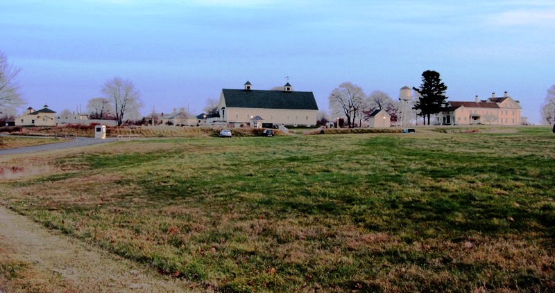
The Wells National Research Reserve at Laudholm Farm is an educational and research facility with 1,600 acres, 7 miles of trails that take you through old fields, woods, marshes and to the beach. During the summer there are guided tours, junior research programs and research projects on birds, the sea level and water.
Form of Government: Town Meeting-Select Board-Manager.
 N43° 19' 5.50\" W70° 34' 58.54\"")
Wells Public Library (’12) @
Additional resources
300th Anniversary, Wells, Maine, 1653-1953. Canton, Me. Pinewood Press. 1953. [University of Maine, Raymond H. Fogler Library, Special Collections; Maine State Library]
Bourne, Edward Emerson. The History of Wells and Kennebunk From The Earliest Settlement To The Year 1820, . . . . Bowie, Md. Heritage Books, Inc. 1983.
Hardy, Joseph W. Settlement & Abandonment on Tatnic Hill: An Eclectic History of Wells, Maine, 1600-1900. Portsmouth, N.H. Back Channel Press. c2008. [University of Maine, Raymond H. Fogler Library, Special Collections; Maine State Library]
*Maine. Historic Preservation Commission. Augusta, Me. Text and photos from National Register of Historic Places: http://pdfhost.focus.nps.gov/docs/nrhp/text/xxxxxxxx.PDF and http://pdfhost.focus.nps.gov/docs/nrhp/photos/xxxxxxxx.PDF
Austin-Hennessey House: 79000171.PDF
Division 9 School: 95001463.PDF
Dorfield Farm: 79000172.PDF
Emery House: 79000176.PDF
First Congregational Church, Former: 91000768: PDF
Former First Congregational Church: 91000768.PDF
Laudholm Farm: 83003702.PDF
Libby’s Colonial Tea Room: 99000769.PDF
Littlefield Homestead: 79000182,PDF
Lord Farm: 79000187.PDF
Wells Baptist Church Parsonage: 79000191.PDF
Shelley, Hope Moody. Beaches of Wells. Dover, N.H. Arcadia Publications. 1997. [University of Maine, Raymond H. Fogler Library, Special Collections; Maine State Library]
Town of Wells, Maine Comprehensive Plan Inventory UPDATE [draft]. September 28, 2004. http://www.wellsme.govoffice2.com/vertical/Sites/%7BA584B478-C2A1-4E71-8B73-02AD3293F2EC%7D/uploads/%7B8F53F4BF-9AC8-4E3F-919D-CE4FA3494CE6%7D.PDF (not accessible in September 2012; try http://www.wellsme.govoffice2.com)
1945 photo courtesy, Maine State Archives, George French Collection
National Register of Historic Places – Listings
Austin-Hennessey Homestead
[Brunt Mill Road] The Austin-Henessey House was the home of one of Wells’ earliest families.
")
")
This Capestyle house with ell and barn was built sometime before 1725, when the earliest deed indicates that Samuel Austin sold it to Samuel Hill. The house has two fireplaces on the center chimney, one of which has a bake oven.* [Frank A. Beard photos]
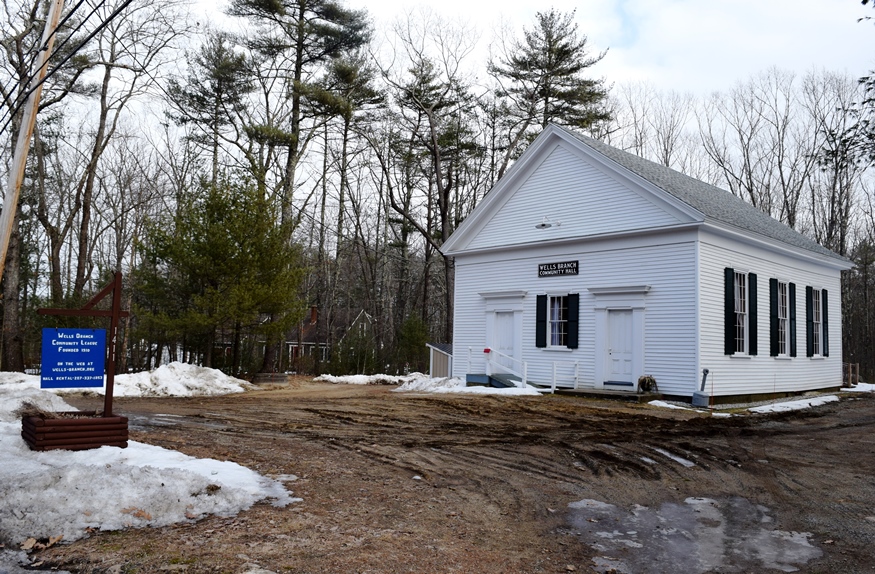
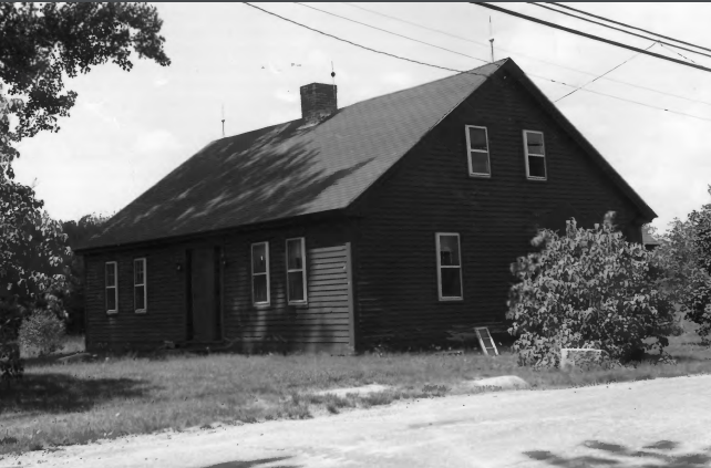
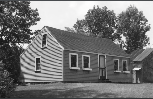
Division No. 9 School
")
[Route 9, south side, 0.15 miles east of junction with Bragdon Road] The 1900 Division #9 School is a one-room schoolhouse maintained as a museum by the Town of Wells. It is the least altered of the several former school buildings in town. Maine Register as a carpenter and undertaker.
Division #9 School served one of the seventeen rural school districts into which the town had been divided since the late 19 century. This division of the town was maintained despite the dramatic decline of the population by one-third since 1850. The Division #9 School remained in use through the 1947-48 school year. In 1992 the former school house was designated as a local landmark.
")
")
Division No. 9 School (2020)
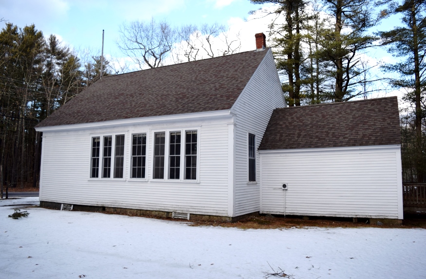
Division No. 9 School (2020)
The one-room schoolhouse was a familiar object in the rural landscape of 19th and early 20th century Maine.
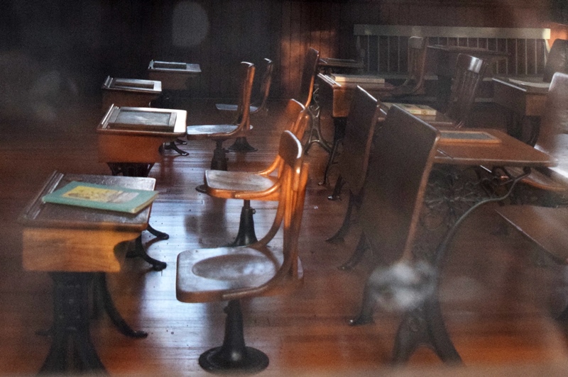
No. 9 School Interior (2020)
Although the district school system became a target for 19th century school reformers, its effect was to produce a vast number and variety of buildings; a figure which at the turn-of-the-20th century totaled more than 4,000 statewide. Twentieth century school consolidation has taken a dramatic toll. In 1960 it was reported that 226 schools in Maine were being held in one-room buildings. Wells had nine former one-room school buildings in 1995.* [Kirk F. Mohney B&W photos]
Dorfield Farm
")
[Harrisecket Road] Dorfield Farm with its Capestyle house was built sometime before 1762 according to a deed that shows James Wakefield as its owner. This makes it the homestead of one of Wells’ earliest families, in the same era as the Austin-Hennessey House above. This house has three fireplaces on the center chimney. The fireplace with a bake oven and ash pit has a full door to close when not in use.* [Frank A. Beard photo]
Early Post Office
Wells Early Post Office (1979)
[Bragdon’s Crossing]
This early post office and home was discovered during renovations to the building.
Deeds traced to 1803 show that Joshua Bragdon sold the property to Daniel Bragdon. The estimated time of original construction is about 1763.*
[B&W photo, Frank A. Beard photo]
Site of an early Post Office in Wells on deadended “Crossings Road” near train tracks. Speculation: a location near a railroad crossing may have been convenient for a post office in early times. (Follow GPS N43 19 15 W70 36 13 to the end; site is NOT on Bragdon Crossing Road off Route 9)
Site of an early Post Office in Wells on deadended “Crossings” Road (2020)
Emery House
") [Sanford Road Highpine] The 1800 Emery House, built by Samuel Emery, was known as the Rose Cottage. The house was a showplace due to the number of rambling roses that covered the entire front of the house and adjoining fences.
[Sanford Road Highpine] The 1800 Emery House, built by Samuel Emery, was known as the Rose Cottage. The house was a showplace due to the number of rambling roses that covered the entire front of the house and adjoining fences.
About 1810 the Goodale family, its owners, had the first iron stove in the area. People flocked to see it.* [Frank A. Beard photo] (Note the pine trees behind the house.)
First Congregational Church, Former
 N43° 18′ 4.8″ W70° 35′ 10.8″")
Historical Society of Wells and Ogunquit @
Southwest corner of Route 1 and Barker’s Lane] The 1862(former) First Congregational Church features a three stage tower and a mix of Romanesque and Gothic detailing. It stands on or near the site occupied by three earlier structures, the first of which is thought to have been built in 1664. Although the exterior of the Church building is rather modest in configuration and similar to other Maine churches, the interior detailing is unusual. According to local historians, the first religious gatherings in Wells began in the early 1640s under the pastorate of Rev. John Wheelwright. However, a permanent meeting house was not erected until about 1664. This very modest first structure burned in 1692 during raids by the Indians. A second structure, built in 1699, was gradually improved and enlarged during the next forty years. The construction of its replacement was begun in the late 1760s. Some of the framing materials used in the earlier building may have been incorporated into the new one, and in turn recycled when the existing church was built in 1862. In 1868 a bell was acquired; a scroll painting by a Mr. Hillings was added in the 1880s. The vestry building was acquired and moved to the site in 1888; a tin ceiling was installed in 1909.*
The First Congregational Church occupied the building on a regular basis until the early 1960s. In 1967, with the merger of the Congregationalists and the Church of Christ in 1963, the 1862 building was transferred to the Historical Society of Wells and Ogunquit.*
Laudholm Farm
") [Laudholm Farm Road] This massive Greek Revival residence, built about 1850 by Theodore Clark, with a porch added about 1890 by George C. Lord, represents the most impressive and sophisticated farmhouse in Maine. Magnificently sited on a hill with fields sloping down to Wells Bay, Laudholm Farm sits on 250 acres of rich farmland. A small earlier residence has been absorbed in the ell. Two Capestyle houses that were farmers’ residences exist nearby. A large barn stands in the rear of the main house.
[Laudholm Farm Road] This massive Greek Revival residence, built about 1850 by Theodore Clark, with a porch added about 1890 by George C. Lord, represents the most impressive and sophisticated farmhouse in Maine. Magnificently sited on a hill with fields sloping down to Wells Bay, Laudholm Farm sits on 250 acres of rich farmland. A small earlier residence has been absorbed in the ell. Two Capestyle houses that were farmers’ residences exist nearby. A large barn stands in the rear of the main house.
")
")
George C. Lord, a financier, who purchased the property in 1881, served for a time as President of the Boston and Maine Railroad. He and his descendants kept the farm working until the 1950s. The Laudholm Farm Trust operates the property in close association with the Wells Preserve. The 1600 acre Rachel Carson Refuge abuts to the northeast. The site is the only large undeveloped saltwater farm remaining in southern Maine and is an oasis of tranquility on an otherwise cluttered coast.*
(see Wells Preserve above)
Libby’s Colonial Tea Room
[now the Johnson Hall Museum, Junction of US 1 and Harraseeket Road. The structure was once the “Tea Room” that hosted functions. [The museum does that as well.]
 N43° 21' 26.03\" W70° 33' 34.49\"")
Libby’s Colonial Tea Room is a bungalow style frame building built for and operated as a road side restaurant along U.S. Route 1 in Wells between 1923 and about 1942. Although it is not entirely certain when Elsie (Klingman) Libby (1882-1973) first opened her dining room, she was in business at this site prior to 1922. In that year a fire destroyed the restaurant. The following spring, a new bungalow style dining room was built on the site of the earlier building. This new facility was advertised as Libby’s Colonial Tea Room, and it remained in operation until the effect of decreased tourist traffic during World War II forced its closure. Among the names in the guest book is that of then New York Governor Franklin Delano Roosevelt who signed it on October 31, 1932, during the campaign that resulted in his first election as President.
")
")
While hotel accommodations at seaside and lakeside destinations with convenient access to railroad connections were well established in Maine during the 19th century, the development of road side facilities for auto tourists witnessed explosive growth in the early 20th century, particularly after World War I. The state’s principal highway corridor during this period was U. S. Route 1, the coastal route from Maine’s border with New Hampshire. A steady rise in the number of road side service stations, motor courts, inns, and restaurants sprang up along U.S. Route 1 and elsewhere. Both the need for such facilities and the popularity of specific establishments (such as Libby’s) provided an economic justification for Elsie Libby to immediately rebuild her dining room after its destruction by fire in 1922. The popularity of Colonialrevival themes in this period, particularly in a community that was settled in the early 17th century, undoubtedly inspired the name of the establishment: Libby’s Colonial Tea Room.
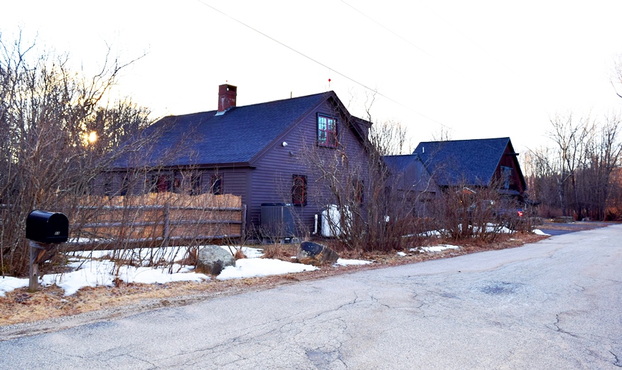
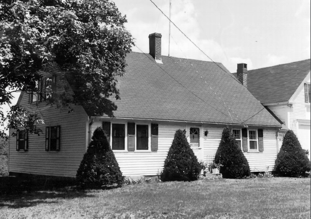
Littlefield Homestead
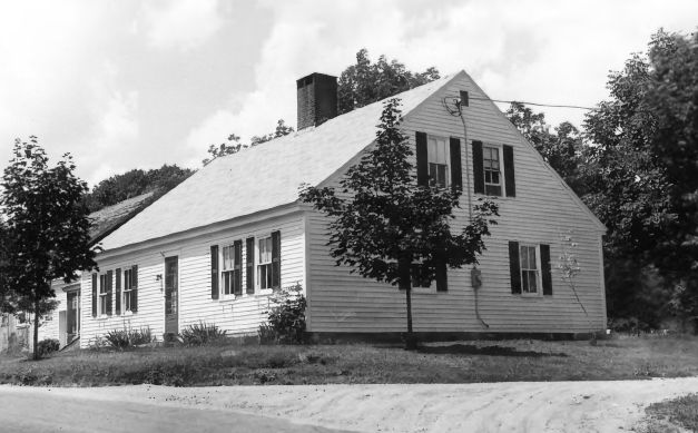 [Chick’s Crossing Road] The Littlefield Homestead, an 18th century, one and one-half story Capestyle house was built at least by 1790. Yet another early house in Wells’ history.
Documentary evidence is scarce but a deed indicates that Joshua Littlefield sold the house in 1856. [B&W Photo probably by Frank A. Beard, 1979]
As with most capestyle houses, modernization has been kind to the simple basic design.
18th Century Littlefield Homestead (2020)
18th Century Littlefield Homestead (2020)
Lord Farm
")
[Laudholm Road] The Wells family were early owners of the Lord Farm, apparently built in the late 1700s. It
consists of a one and one-half story Capestyle house and an attached barn. Stephen Wells was the owner in 1781; Alexander Wells was the owner in 1856.
Four fireplaces share the the central chimney. The interior features ornate moldings, wainscoting, gunstock posts and a fine stair banister.* [Frank A. Beard photo]
Spiller Farm Paleoindian Site, Address Restricted
Wells Baptist Church Parsonage
 [Maine Route 9A] The parsonage was built before 1779 and is described as “an 18th century Capestyle. In 1979 the owners was “Parish of the Wells Branch Baptist Church.” It is described as “Homestead farm of an early wells family.”
In 1779 Nehemiah Littlefield heirs sold the house to William Littlefield. In 1845 Clement Littlefield sold the property to the Church for use as the parsonage.* [Frank A. Beard B&W photos, 1979]
(2014) Photo By Magicpiano – Own work, CC BY-SA 3.0, https://commons.wikimedia.org/w/index.php?curid=34962831
Wells Homestead
 [Sanford Road] This 18th century capestyle house is described as the “Homesteads of one of Wells’ earliest families.” Here are quotes from the somewhat disjointed Historic Preservation Survey. “Oldtimers called this the second oldest house in Wells” “Piece of an old beam as the date 1696 engraved on it.” “Reportedly home of John Wells. “First built in 1696, burned by the Indians in 1702 and rebuilt 1710.” “Much of interior has been stripped, fireplace removed.” “Wainscotting does remain in right front room.” “* Property purchased in 1707 by John Wells, mariner.”* [Frank A. Beard photo, 1979]
Information on the following “homesteads” is based on an Historic Preservation Survey conducted by the Wells Historic Preservation Commission. The houses in this “Wells Capestyles” series All are considered “Homesteads of one of Wells’ earliest families.” Little background on each is available.
Charles Perkins House. Mid to late 1700s. 18th century one story capestyle. Probably owned by David Maxwell during the mid- to late- 1700s.
Three fireplaces, one with bake oven. Wainscoting remained in two of the rooms in 1979. Location was reported as “Scotch Hill, Ogunquit Wells, York County, Maine.”
Eaton House. [Sanford Road.] Mid to late 1700s. 18th century one and one-half story capestyle. Three fireplaces on a central chimney. No bake oven. Front stairway to the left with banister. Wainscoting remained in all rooms in 1979.
")
Eaton House (1979)
Nason Hatch inherited the house from his father in 1803. Alvah Littlefield purchased it from Nason Hatch in 1854. (Frank A. Beard photo 1979)
Hatch House. [Sanford Road] One story Capestyle house built about 1800 by Jeremiah Hatch in the 18th century style.
")
Hatch House (1979) (Frank A. Beard photo)
Littlefield-Keeping House. [Charles L. Chase Road] Yet another 18th century capestyle house. (The owner in 1979 was Doris Keeping.) A deed written in 1774 indicates Isaac Littlefield obtained land from Jeremiah Wheelwright. Isaac’s son Joseph received the property with buildings in 1799. Apparently the home was built sometime between 1774 and 1799, thus the estimate of 1785 for construction.
Originally a half capestyle house with only one window on either side of a front door, the interior shows where an additional window was added on the south side. There are two small fireplaces in each front room. he back room has a beehive bake oven with a metal door and a box-like area where water was heated. No fireplace is in this room. (Frank A. Beard photo, 1979)
Littlefield Tavern. [Chase L. Charles Road.] This 18th century capestyle house apparently operated as a tavern in Wells. The eldest son of Edmund Littlefield, Francis, Sr., was a tavern keeper. The house was built by Captain James Littlefield, a slave owner, about 1735. A Slave cemetery is located across the street.
 Frank A. Beard photo.")
Littlefield Tavern (1979) Frank A. Beard photo.
Littlefield-Chase Farmstead. [Route 9, North Berwick Road] This 18th century capestyle house had been in the same family since it was built by either Dependenee or Daniel Littlefield in 1776. In 1979 it was owned by Richard and Elizabeth Chase.
")
Littlefield-Chase Farmstead. (1979)
It has a large fireplace with bake oven in the right front room. Littlefields are referred to as “Wells’ earliest family” in the supporting nomination report.
")
Littlefield-Chase Farmstead. (Frank A. Beard photo, 1979)
Littlefield-Dustin Farm. [Dodge Road] This 18th century 1-1/2 story capestyle house was built prior to 1784, according to the National Register nomination. In 1979 Richard Dustin owned the house. William Sayer purchased the property in 1784 from a Captain Littlefield. The configuration of the house, according to a researcher, “indicates [a] considerably earlier date” for the age of the house.
1979 Frank A. Beard photo
Goodale-Bourne Farm. [North Village Road] This capestyle house was built about 1740. Zachariah Goodale, Jr., an early settler in Wells, owned the property prior to 1749. In 1979, Frank C. Bourne was the owner. The left front room has a large fireplace with a bake oven at is side. A center front stairway goes to the left.
")
Goodale-Bourne Farm (1979, Frank A. Beard photo)
Goodale-Stevens Farm. [North Village Road] This 1-1/2 story capestyle house was built in 1725. Although Zachariah Goodale was clearing the land as early as 1699, Indian conflicts delayed home building until the early 1700s.
The right front room has the usual large fireplace and a bake oven at its side. A “Y” shaped center stairway leads to the upper story. Alice Stevens was the owner in 1979.

Goodale-Stevens Farm (1979, Frank A. Beard photo)
Mill House. [Post Road, U.S. Route 1] A saw mill was operated here from the late 1600s to the 1930s. Around 1750 the 1-1/2 story capestyle house was built. In this case the right front room has no fireplace. However, it does have the brickwork with the box-like enclosure to heat water with a pit beneath. A bake oven is in the brickwork beside it. The center back room has paneling surrounding the fireplace and full window shutters that slide into the wall.
The left front room does have a fireplace, more ornate molding and half window shutters. A “Y” shaped stairway with banisters is at the front entrance.
")
Wells Mill House (1979, Frank A. Beard photos)
")
Wells Mill House (1979, Frank A. Beard photos)