T3 R4 BKP WKR

Location Map T3 R4 BKP WKR
This township hosts the Long Falls Dam on the Dead River. That dam maintains the level of Flagstaff Lake, but required the removal of the village of Flagstaff, which was flooded as a result of its construction..
There was a small natural lake at Flagstaff. In 1950, Central Maine Power Company (CMP) built the Long Falls Dam to create a storage impoundment to supply an even flow of water for the downstream Kennebec River hydroelectric dams and for flood control. There is no generating capacity at the Long Falls Dam.*
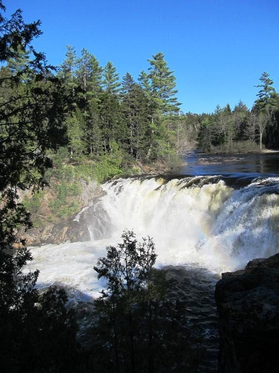
The “falls” is a long series of rapids below the dam. It attracts fishermen who wade in its swift waters, disregarding the strong warnings posted nearby.
 N45° 13' 49.41\" W70° 12' 0.70\"")
Dead River at Long Falls (2013) @
 N45° 13' 52.76\"")
Two fishermen in the Dead River at Long Falls
 N45° 13' 51.72\" W70° 11' 43.79\"")
Warning near Long Falls (2013) @
In addition to the dam, the township is the relatively new home to miles of the Maine Hut Trail. With Spring Lake between Flagstaff Mountain and Blanchard Mountain, the terrain offers much to people who enjoy hiking and camping.
The North Flagstaff Road winds along the north shore of Flagstaff Lake from the Dead River to Eustis on the Big Eddy Road. The Loop Road follows the left bank of the Dead River for about two miles from the dam, turns west near the north shore of Spring Lake, then joins the North Flagstaff Road.
See images of Flagstaff Lake from Dead River Township.
 N45° 13' 48.98\" W70° 12' 1.03\"")
Signs for Flagstaff, Loop, and Long Falls Dam roads (2013) @
 (2013) N45° 13' 58.54\" W70° 11' 26.29\"")
Sign for the Flagstaff Hut on the Maine Hut Trail (2013) @
 N45° 13' 11.47\" W70° 11' 20.15\"")
“State Of Maine, Public Reserved Land, Dead River Unit” (2013)
About one square mile of land surrounding the Long Falls Dam and the “falls” area is within the Dead River Unit of Maine Public Reserved Land.
On the Long Falls Dam Road, a sign announces the Unit’s location. The Unit, administered by the Bureau of Public Lands in the Maine Department of Conservation, also extends into Dead River Township along the shore of Flagstaff Lake.
Five miles north of Long Falls Dam, Delorme’s Maine Atlas and Gazetteer notes a “classic horseshoe falls, unusual in Maine.” Brady G. Williams photo (2020)
More Videos!
Additional resources
* Townsend, Clinton. “Fiasco at Flagstaff Lake.” Maine Rivers. Spring/Summer 2012.
p. 1.