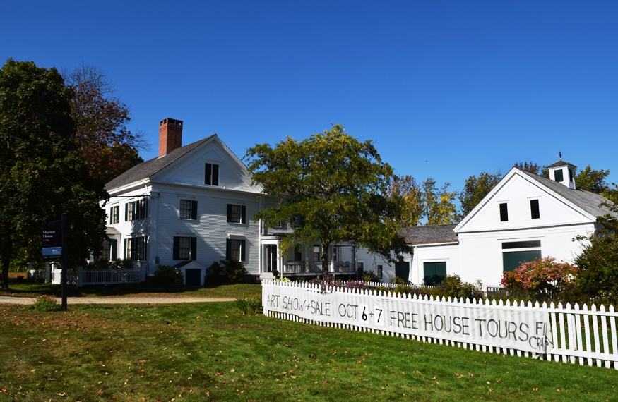
Daniel Marrett House on East Ossippee Trail (one of several historic buildings in Standish) (2018)

Location Map for Standish
| Year | Population |
|---|---|
| 1970 | 3,122 |
| 1980 | 5,946 |
| 1990 | 7,678 |
| 2000 | 9,285 |
| 2010 | 9,974 |

Population Trend 1790-2010
| Geographic Data | |
|---|---|
| N. Latitude | 43:47:30 |
| W. Longitude | 70:34:30 |
| Maine House | Dist 22,23 |
| Maine Senate | District 26 |
| Congress | District 1 |
| Area sq. mi. | (total) 83.7 |
| Area sq. mi. | (land) 59.1 |
| Population/sqmi | (land) 167.1 |
County: Cumberland
Total=land+water; Land=land only |
|
 [STAN-dish] is a town in Cumberland County, established from a 1750 grant to captains Humphrey Hobbs and Moses Pearson for military services to the British crown.
It was settled in 1760 and incorporated on November 30, 1785 from Pearsontown Plantation. After annexing land from Buxton in 1824, it ceded land to Gorham (1831, 1839) and Raymond (1869).
The Saco River forms its western boundary, separating the town from several others in York County. The Oxford-Cumberland Canal allowed passage of boats from Harrison to Portland.
")
Sebago Lake Launch (2001)
")
Cumberland-Oxford Canal (01)
Named in honor of Captain Miles Standish, the military leader of the Plymouth Colony, the town has a very long shoreline on Sebago Lake in its southwest corner, including its Lower Bay.
")
Mill Ruins Steep Falls (2012)
")
Mill at Rail Tracks (2012)
")
In the 1880’s, the town had a substantial number of mills and factories producing lumber, carriages, flour and meal, ice, plaster, packing boxes, and shooks and staves. The main villages then included Standish and Steep Falls. Steep Falls was a thriving village historically with its excellent water power on the Saco River and the railroad station in its midst.
The falls are just upstream from the bridge spanning the Saco to Limington. [click to enlarge photos]
")
Bridge in Steep Falls (2012)
")
Steep Falls on the Saco (2012)
")
Steep Falls Park – A Veterans Memorial (2012)
")
Orchard on Route 25 Entering Standish (2012)
The intersection of routes 25 and 113 is known as “Two Trails.” The name recalls the historic Sokokis Indian walking trails on these modern roads: the Ossipee Trail and the Pequawket Trail, respectively. Ossipee and Pequawket are two branches of the Sokokis tribe, which inhabited the Saco River area. The tribe is known for annual pilgrimages on these routes from as far north as the Fryeburg area to Biddeford Pool to fish and harvest shellfish.*
")
Sign for Pequawket Trail on Route 113 (2012)
")
Sign for Historic Paine Neighborhood (2012)
Roughly two miles north of Two Trails, on Route 113 near Watchic Pond, one enters the Paine Historic Neighborhood District. The district, comprised of three private homes and a cemetery, is recognized by the Maine Historic Preservation Commission as “perhaps the best example of a typical settlement pattern in 18th century Maine: the movement of several members of a family to a new location forming a “neighborhood” with a social distinction which continued to characterize it for several generations.” Two homes in the neighborhood date to 1795.*
")
General Store in Steep Falls (2012)
")
Steep Falls P.O. (2012)
")
Church in Steep Falls (2012)
The historic Daniel Marrett House was the storage place for coins from Portland banks in anticipation of a British attack in 1812. In 1866, future U.S. Representative to Congress Simon Hamlin, was born in the village of Richville in Standish.
While Steep Falls village is in the northwest corner of the township, Standish Village is in the South at the intersection of Routes 25 and 35, and Oak Hill Road. A stone monument marks the “Site of Fort 1753, First Church 1768”. Nearby on Oak Hill Road sits the historic “Old Red Church” also known as “First Parish Meetinghouse”.
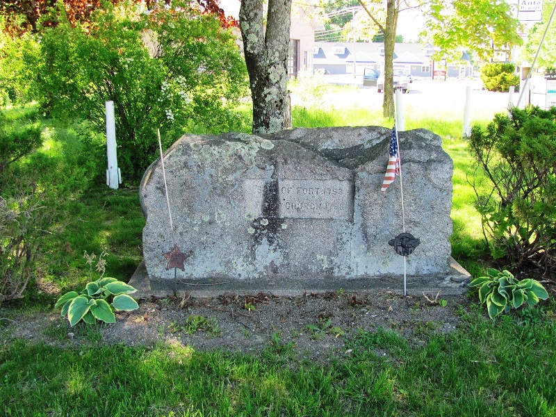
Site of Fort 1753, First Church 1768 (2010)
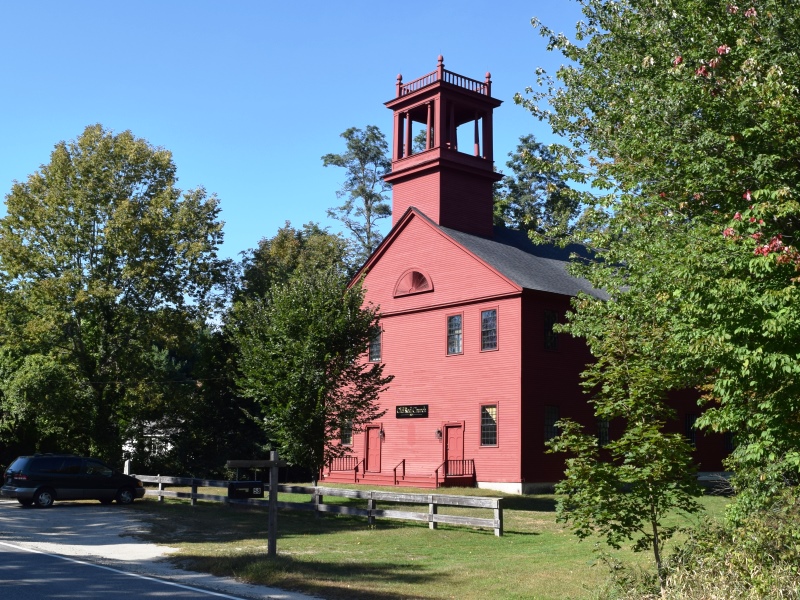
1804 Old Red Church (2018)
The Daniel Marrett House museum is here. Both a recreational area and suburb of Portland, the town is served by Maine Routes 11, 25, 35, 113, 114 and 237.
On Oak Hill Road several fine homes and the well kept village cemetery are near the village center and the Congregational church.
")
")
")
Form of Government: Town Meeting-Council-Manager.
Additional resources
Barnes, Jack. Sebago Lake, West Shore: Standish, Baldwin, Sebago, and Naples. Charleston, SC. Arcadia Publishing. 2000.
Daybook, 1798-1848. (Cataloger Note: Daybook recording purchases by customers from an unidentified business in Standish, Maine, probably a general store and sawmill.) [University of Maine, Raymond H. Fogler Library, Special Collections]
*Maine. Historic Preservation Commission. Augusta, Me. Text and photos from National Register of Historic Places: http://pdfhost.focus.nps.gov/docs/nrhp/text/xxxxxxxx.PDF and http://pdfhost.focus.nps.gov/docs/nrhp/photos/xxxxxxxx.PDF
Cumberland and Oxford Canal: 74000317.PDF
First Parish Meetinghouse: 75000204.PDF
Marrett, Danielo, House: 74000314.PDF
Paine Neighborhood Historic District: 85000731.PDF
Steep Falls Library: 03001406.PDF
Standish Corner Historic District: 93001117.PDF
“National Register Nominations.” Maine Preservation. Spring 2004. p. 8.
The Sebago Lake Area: Windham, Standish, Raymond, Casco, Sebago, and Naples. Dover, N.H. Arcadia Publishing. c1996.
Scenic Byway Eligibility Application. Prepared by: Androscoggin Valley Council of Governments, Southern Maine Regional Planning Commission, Western Maine Cultural Alliance. January 5, 2007. http://www.smrpc.org/transportation/corridor/Rt%20113/web%20copy%20Final%20State%20Byway%20Application.pdf (accessed April 4. 2012)
Sears, Albert J.The Founding of Pearsontown (Standish), Maine. Bowie, Md. Heritage Books. 1991. [Maine State Library]
National Register of Historic Places – Listings
Cumberland and Oxford Canal
[from Sebago Lake Basin to Conant Street] The Cumberland and Oxford Canal was designed to open the interior of southern Maine to development by connecting existing bodies of water with Portland Harbor. It was to run from Waterford in Oxford County to Portland. (The section of the canal in Oxford County was never built.) Surveying began in 1825; excavation began in 1828 and was completed in 1830. The canal opened on June 1, 1830.
The entire distance opened to navigation was 38 miles. Eighteen miles made use of existing waterways: from Harrison at the head of Long Lake, across Long Lake, down the Songo River and across Sebago Lake to Sebago Lake Basin. From the foot of Sebago Lake Basin the canal followed a southerly and southeasterly route along the western side of the Presumpscot River to Westbrook, turned easterly across the countryside to Stroudwater, and from there followed a course along the eastern bank of the Fore River to the foot of Clark Street at the Portland waterfront.* [See Canals.]
First Parish Meetinghouse
")
First Parish Meetinghouse (1974)
")
First Parish Meetinghouse (2018)
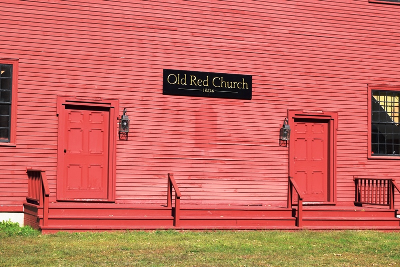
[Oak Hill Road; N43° 44′ 16.75″ W70° 33′ 20.49″] The First Parish Meetinghouse (The Old Red Church) was built between 1804 and 1806 to replace the old meetinghouse in the center of town. It had been irreparably damaged by a group of intoxicated soldiers. Rev. Daniel Marrett (see below), who had been ordained as pastor in the community in 1796, donated the land. He was born in Cambridge, Massachusetts in 1767 shortly after which his family moved to Lexington where, at the age of eight, he witnessed the battle on the green in 1775. After coming to Standish he lived in the house built by Benjamin Titcomb in 1789. He dedicated the “Old Red Church” in 1806 and remained as pastor and community leader until 1829 when he was succeeded by Rev. Thomas Tenney.
First Parish Meetinghouse (2018)
A religious rift occurred shortly thereafter over the issue of Unitarianism and in 1834 Rev. Tenney led a group which split off to form the Evangelical Congregational Church. Those remaining adopted a Unitarian Covenant and the meetinghouse was used for their services until 1860. In 1848 the second story of the church (meetinghouse) was remodeled to serve as an academy. This project was short lived, however, when in 1852 one of the Board members absconded with all the funds. From 1893 to 1898 and again from 1902 until 1914 the building was used as the Standish High School. Although the building is no longer in regular use, services have been held there each Sunday in August. This fine old building and landmark retains a simplicity and dignity inherited from 18th century architectural tradition and has served its community in varied capacities for many years.* [Frank A. Beard B&W photo, 1974]
Marrett, Daniel, House
") [on Maine Route 25] The 1789 Daniel Marrett House was built by Benjamin Titcomb and was owned for a short time by Mr. Gould, the first settled pastor of the town. Marrett studied theology and in 1796 was ordained pastor of the Meetinghouse (see above). He moved into his house and did some of the finish work in the house himself. He not only was the spiritual leader of the people of Standish but was also in many respects their temporal leader.
[on Maine Route 25] The 1789 Daniel Marrett House was built by Benjamin Titcomb and was owned for a short time by Mr. Gould, the first settled pastor of the town. Marrett studied theology and in 1796 was ordained pastor of the Meetinghouse (see above). He moved into his house and did some of the finish work in the house himself. He not only was the spiritual leader of the people of Standish but was also in many respects their temporal leader.
In 1814 the Cumberland Bank of the City of Portland sent its gold and silver coin in kegs to the Marrett House in Standish for safekeeping. The floor in one of the rooms was strengthened at this time to take the unusual weight.
")
")
Miss Caroline Marrett left the house to the Society for the Preservation of New England Antiquities in 1944. The Society has been maintaining this lovely house with its gardens and outbuildings since then. Its handsome late 18th century interior provides the setting for a rich family accumulation of possessions which reflect the changing styles and tastes through a long period of the nation’s history.* [R.D. Kelly B&W photo]
Paine Neighborhood Historic District
[Maine Route 113] The Paine Neighborhood is perhaps the best example of a typical settlement pattern in 18th century Maine: the movement of several members of a family to a new location forming a “neighborhood” with a social distinction which continued to characterize it for several generations.
Four Paine brothers came to Maine from Eastham, Massachusetts, in 1780. Joseph, William, Thomas, and Richard’s ancestors were early settlers of Cape Cod. William and Richard settled in Gorham, Joseph and Thomas in Standish.The home of Joseph Paine disappeared a great many years ago but three of his sons built homes within a few hundred yards of each other which comprise the “Paine neighborhood.” Located between the houses is the Paine Cemetery where the original settlers and many of their descendants are buried. All three houses continued in the ownership of Paine descendants well into the 20th century and were maintained with pride.*
Standish Corner Historic District
") [junction of Maine Route 25/113 and Maine Route 35] This Historic District contains five frame dwellings that illustrate the late 18th and early 19th century development of this crossroads community. Centered around the former site of a 1754 fort and the town’s first church, Standish Corner was the principal local trading center until it was bypassed by the Portland and Ogdensburg railroad in the late 1860s. Mid-to late-20th century redevelopment resulted in the significant alteration of the Corner’s historic appearance, leaving the five properties as the last important group to remain.
[junction of Maine Route 25/113 and Maine Route 35] This Historic District contains five frame dwellings that illustrate the late 18th and early 19th century development of this crossroads community. Centered around the former site of a 1754 fort and the town’s first church, Standish Corner was the principal local trading center until it was bypassed by the Portland and Ogdensburg railroad in the late 1860s. Mid-to late-20th century redevelopment resulted in the significant alteration of the Corner’s historic appearance, leaving the five properties as the last important group to remain.

Stone monument “Site of Fort 1753, First Church 1768” the intersection of routes 25 and 35
The area was granted in 1750 to Captains Humphrey Hobbs and Moses Pearson and their companies for services in the siege of Louisburg. Settlement did not begin until 1760. The location on what was essentially the frontier during the French and Indian Wars prevented any sustained settlement until hostilities ceased. By the mid to late 1760s, Standish (then known as Pearsontown) was beginning to have an influx of settlers. One was Ebenezer Shaw of Hampton, New Hampshire who was enticed by the proprietors to built a sawmill in 1762. Several years later, the proprietors fulfilled their obligation to build a Congregational meeting house and settle a minister. Building activity within the historic district began in 1789 with the construction of a substantial two-story house. Later known as the Marrett House, this handsome home is typical of Maine houses of the period with its center chimney and symmetrically composed five-bay facade.
Before the Civil War Standish Corner was the principal local trading center and home of several small scale factories. The Corner also retained its importance as the religious and educational center, with the Evangelical Congregational Church erecting a church here in 1834 and the Methodists adding theirs fifteen years later. In 1848 Standish Academy opened with its classes held in the upper story of the First Parish Church. It closed in 1857. Significant changes were also made to the Marrett House in the late 1830s or 1840s when the existing Greek Revival ornamentation was added and its large connected barn built.*
")
Steep Falls Library
[1128 Pequawket Trail] The Steep Falls Library is a one-story Colonial Revival brick building designed by Edward F. Fassett in 1916, and enlarged by John Calvin Stevens and John Howard Stevens in 1924.
The main section was the gift of Henry Pierce to his native village of Steep Falls. Henry was the son of Captain William Pierce. In 1849 when the California fever called, Henry prepared a plan for starting a business in San Francisco, shipping the materials around Cape Horn. He, with other family members who migrated to California over the following years, became very successful in a variety of enterprises that included a bakery business, flour and grain, dairying, a rubber company which made belting to run machines, and a paper company.
Pierce apparently did not inform family members of his intentions concerning Steep Falls. It was many years after his death that a family member discovered the library on a trip east. Mrs. Henrietta Pierce Watkinson, a daughter of Henry’s brother, Marshall who was living nearby in Baldwin, was instrumental in the decision to build the Children’s room in 1924.*