
Location Map for Seboeis
| Year | Population |
|---|---|
| 1970 | 63 |
| 1980 | 53 |
| 1990 | 40 |
| 2000 | 41 |
| 2010 | 35 |
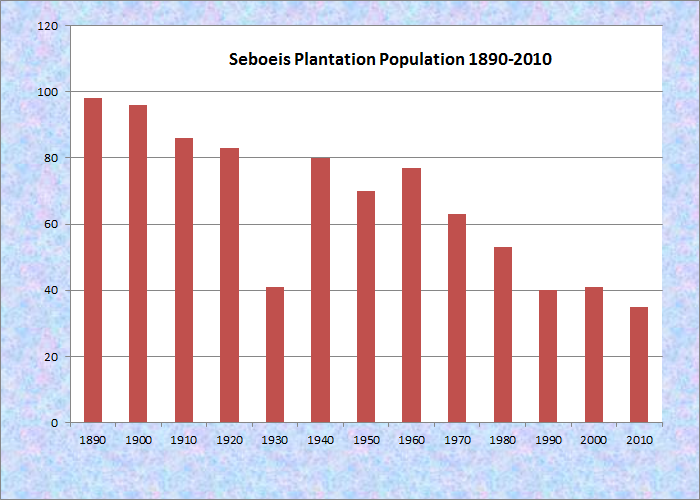
Population Trend 1890-2010
| Geographic Data | |
|---|---|
| N. Latitude | 45:22:56 |
| W. Latitude | 68:45:00 |
| Maine House | District 142 |
| Maine Senate | District 5 |
| Congress | District 2 |
| Area sq. mi. | (total) 41.7 |
| Area sq. mi. | (land) 40.0 |
| Population/sq.mi. | (land) 0.9 |
County: Penobscot
Total=land+water; Land=land only |
|
[seh-BOW-iss] is a plantation in Penobscot County, organized on March 31, 1890 from township T3 R8 NWP. Its organization was confirmed by the legislature in 1895.
According to the Maine Bureau of Parks and Lands, early “Indians came to this area as the ice sheet retreated 13,000 years ago. Native Americans have lived in the region ever since in close relationship with its land, water and wildlife. European settlers first arrived in the early 1800s, and many were involved in lumbering. Timber harvesting at Seboeis dates back multiple generations, and the current mix of hardwoods and softwoods reflect that history. Mills were located at the outlets of both Endless and Seboeis lakes.”
The name, meaning “little brook,” may have its origins in a description of a portion of Seboeis Stream that begins its journey out of Endless Lake much smaller than it is when it exits the plantation several miles to the south.
Other than South Branch Lake on its eastern boundary, and the Canadian Atlantic Railway line in the south, the area has few outstanding physical features.
The small Seboeis village is nearly at the end of the Seboeis Road, which leads north in Howland from the North Howland Road. The village is less than a mile from the shore of South Branch Lake, where there is a boat launch.
Seboeis Public Reserved Land of 15,628 acres provides opportunities for boating, camping, fishing, hunting, snowmobiling, and watching wildlife. While the full reserve covers areas outside the plantation, a section near Hazeltine Ridge and the West Branch of Seboeis Stream is located a few miles north of Seboeis village.
Form of Government: Assessors-Annual Meeting.
Additional resources
Maine Bureau of Parks and Lands. “Seboeis Public Reserved Land.” http://www.maine.gov/cgi-bin/online/doc/parksearch/index.pl [select “Seboeis Public Reserved Land”] (accessed March 15, 2012)