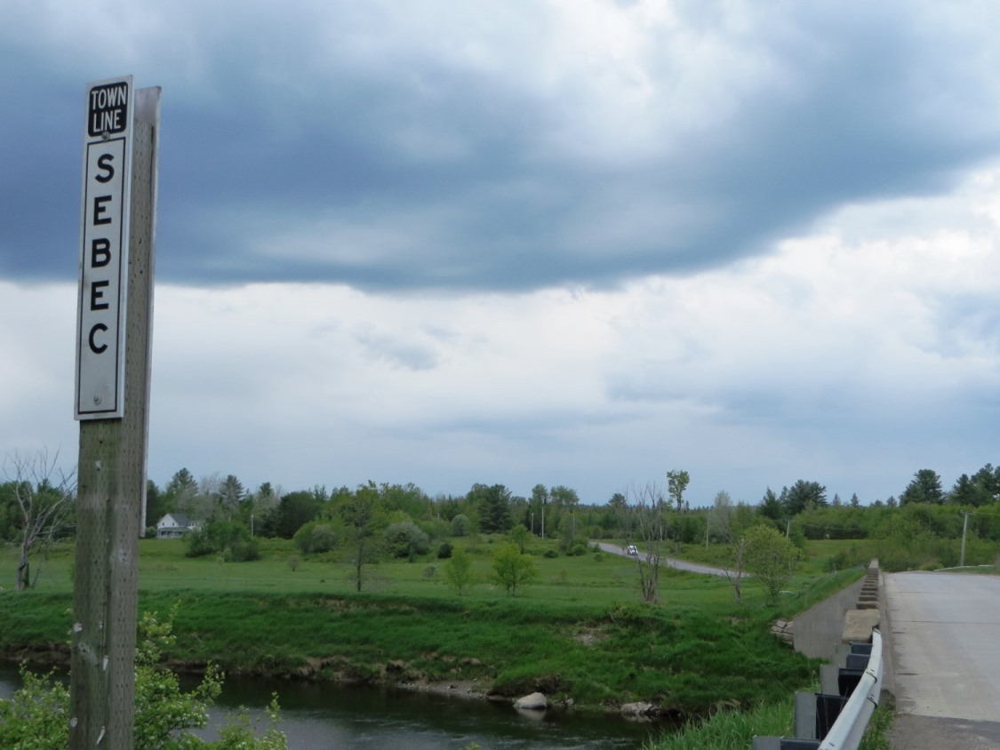

Location Map for Sebec
| Year | Population |
|---|---|
| 1970 | 325 |
| 1980 | 554 |
| 1990 | 469 |
| 2000 | 612 |
| 2010 | 630 |

Population Trend 1820-2010
| Geographic Data | |
|---|---|
| N. Latitude | 45:14:31 |
| W. Longitude | 69:06:26 |
| Maine House | District 119 |
| Maine Senate | District 4 |
| Congress | District 2 |
| Area sq. mi. | (total) 38.0 |
| Area sq. mi. | (land) 37.0 |
| Population/sq.mi. | (land) 17.0 |
| County: Piscataquis
Total=land+water; Land=land only |
|
[seh-BEK] is a town in Piscataquis County, incorporated on February 28, 1812 from the township T4 R7 NWP. This made Sebec the first town in the county.
It ceded land to Plantation T3 R6 in 1818 and to Bowerbank in 1927.
In the 1820’s and 1830’s, several stores were in operation in the Village. The origin of the name is the same as that of Sebago and reflects the idea of a “great lake.” Sebec village lies at the eastern most end of Sebec Lake.
The Gazetteer of Maine had these observations in 1886 [edited with excerpts]:
Sebec is in the southern part of Piscataquis county, 10 miles north-east of Dover, on the Bangor and Piscataquis railway. There are several small ponds in town. Sebec Lake lies partly within its limits, and the outlet furnishes two excellent water powers. The Piscataquis river forms its boundary line on the south. The principal manufacturing is on the outlet of Sebec Lake at the village. There are at this place a saw-mill producing large and small lumber, a cedar tub factory, a carriage and a woolen factory. South Sebec is the other village of the town.
Capt. Ezekiel Chase was the first clear settler. He had been a Revolutionary soldier, loved to roam the forest, and had become a successful hunter. He once took four hundred dollars worth of furs at a single hunt. In 1802, he selected his lot on the Piscataquis River, and felled an opening in 1820. (cleared the land) He had been a Revolutionary soldier, loved to roam the forest, and had become a successful hunter.
The first store was opened by Mr. Towle, who soon took in Solomon Parsons as his partner. J. Lamson and son opened the second store; and John and Nathaniel Bodwell, in 1823, started a hatter’s shop.
At the time the town supported nine schoolhouses with a population in 1880 of 876. The Sebec Woman’s Christian Temperance Union was organized on July 23, 1894. Its mission was to prohibit alcoholic beverages and encourage personal abstinence. In 1886 there were two Methodist societies, one Baptist and one Free Baptist. It had nine public schoolhouses in that year. END Varney
The 6,000+ acre Sebec Lake, shared with Bowerbank and Willimantic, dominates the northwestern area of the town.
While the lake has a maximum depth of 155 feet, the portion in Sebec ranges from 40 feet to less than 10 feet near its outlet to the Sebec River in Sebec village.
Several small ponds dot the landscape, including the 28-acre Garland Pond. A small “chain of Ponds” (Harriman, Parker and Dow) release their outlet streams to the Piscataquis River.
Through removal of unwanted species and stocking of brook trout, the pond supports the trout fishery.
It is accessible at the town line with Dover-Foxcrft on combined Route 6/16.
In the south of the town, the Piscataquis River forms much of the boundary between Sebec and Atkinson.
The rich farmland near the river appears to be productive.
 N45° 12' 18.08\" W69° 4' 47.08\"")
Cropland near the Piscataquis River in Sebec (2014) @
 N45° 12' 17.57\" W69° 4' 47.43\"")
Piscataquis River between Atkinson and Sebec, right (2014) @
 N45° 12' 17.35\" W69° 4' 47.17\"")
Piscataquis River between Atkinson and Sebec, left (2014) @
Located between Dover-Foxcroft to the west and Milo to the east, the town is connected to both by Maine combined Route 6 and 16, and by the Piscataquis River. Here are some rural views on Route 16:
 N45° 14' 31.15\" W69° 2' 34.64\"")
 N45° 13' 41.32\" W69° 6' 15.76\"")
 N45° 13' 45.39\" W69° 5' 43.84\"")
Sebec Corners on Route 16 in Sebec (2014) @
Form of Government: Town Meeting-Select Board.
Additional resources
Maine. Historic Preservation Commission. Augusta, Me. Text and photos from National Register of Historic Places.
Roberts, Gwilym R. Sebec, Maine: Before, During, and After the Civil War. Farmington, Me. University of Maine Farmington. Printing Department. 1991.
Sawtell, William R. Old Sebec. W.R. Sawtell, c1999-2007. (Old Town, Me. Howland’s Printing) [University of Maine, Raymond H. Fogler Library, Special Collections; Maine State Library; Bangor Public Library]
Woman’s Christian Temperance Union (Sebec, Me.) Records, 1894 July 23-1899 March 23. (Cataloger Note: Records of a local union of the Woman’s Christian Temperance Union in the late 19th century in Maine. Included are minutes of the meetings, lists of members, and lists of officers.) [University of Maine, Raymond H. Fogler Library, Special Collections]
Varney, George J. A Gazetteer of the State of Maine. 1886. pp. 506-507; and “A History of Sebec, Maine.” from the Gazetteer.
National Register of Historic Places – Listings
Burgess House
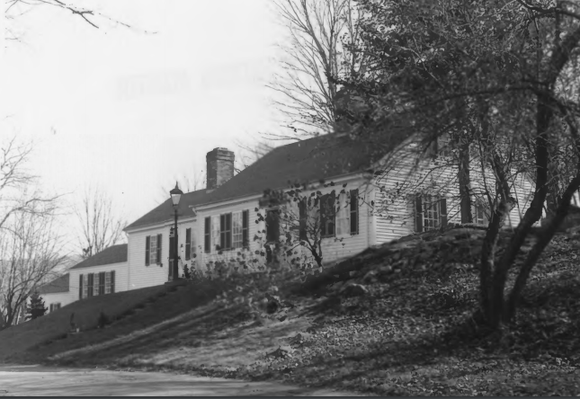 [off Maine Route 11] The c. 1816 Burgess House, probably built by Ichabod Young, was occupied during the latter half of the 19th century by the Thomas A. Burgess family. Young built a fulling mill across the Sebec River from the house, the first such mill in Piscataquis County. This site, at the outlet of Sebec Lake into the Sebec River was the scene of the earliest settlement in the town beginning in 1802. A natural fall of 18 feet made it an ideal location for waterpower industry and by 1830 seven mills were operating in this location. At that time Sebec was the leading business center in the county and continued to be for another twenty years. Sebec today is a tiny quiet village and all that remains of its once thriving industry are a few foundation ruins on the river bank.
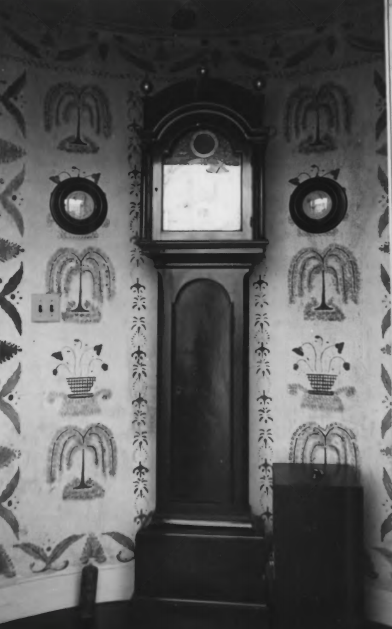
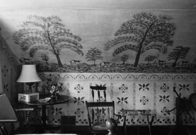 The Burgess House, though unpretentious externally, reflects through its interior the prosperity which once existed in the community. The rooms, small in scale, are nonetheless finished with great care and attention to detail and include fine wood paneling on the ground floor. The most important feature is the extremely well preserved fresco and stencil work. Virtually every wall is ornamented with freehand or stenciled decoration which with the exception of a few slightly faded areas retains its original vibrancy of color or nearly so. Probably executed a few years after construction, this work has been authoritatively attributed to Rufus Porter and his associate, Moses Eaton, Jr. in the early 1820s.* [Frank A. Beard photos, 1977]
Harriman School
[north side of North Road, 1.7 miles Northeast of junction with Parson Landing Road] Built about 1860, the Harriman School is the oldest and in better condition of the two one-room schoolhouses in Sebec. Probably built for religious purposes, it was converted shortly thereafter to a school. Soon it became part of a local system that supported sixteen school houses in ten separate school districts (the Harriman School served District #4). Within twenty years, the declining population had forced a contraction in this system with only nine school houses in use in 1881. The Harriman School continued to function as a school until 1933 when the town’s schools were consolidated into a pair of two-story buildings at Sebec Village and Sebec Corner.
") Thereafter it was vacant until 1947 when a community club was formed to rehabilitate the building but interest waned until 1966 when the newly formed Sebec Historical Society acquired the property and converted it into a museum. The one-room schoolhouse was a common feature of Maine’s historic rural landscape. Typically of wood and covered with weatherboards and/or wood shingles, these modest gable roofed buildings usually had a rectangular shape with a facade that contained one or two entrances and sidewalls with several windows. In the 19th century they rarely gave any hint of prevailing architectural fashions. However, in the early 20th century this pattern changed as the State began to develop model school plans designed by professional architects that could in turn be provided to interested towns. Inasmuch as the Harriman School was originally built for religious purposes, its overall scale and the detailing sets the building apart from most rural school houses of this period.* [Kirk F. Mohney photos, 1996]
Thereafter it was vacant until 1947 when a community club was formed to rehabilitate the building but interest waned until 1966 when the newly formed Sebec Historical Society acquired the property and converted it into a museum. The one-room schoolhouse was a common feature of Maine’s historic rural landscape. Typically of wood and covered with weatherboards and/or wood shingles, these modest gable roofed buildings usually had a rectangular shape with a facade that contained one or two entrances and sidewalls with several windows. In the 19th century they rarely gave any hint of prevailing architectural fashions. However, in the early 20th century this pattern changed as the State began to develop model school plans designed by professional architects that could in turn be provided to interested towns. Inasmuch as the Harriman School was originally built for religious purposes, its overall scale and the detailing sets the building apart from most rural school houses of this period.* [Kirk F. Mohney photos, 1996]
Nice article. Is it possible that the Burgess House was once owned by Elerton Jetty of Hathaway Shirt Co.? I recall in the late 1950’s (vacations in Sebec for years) I attended a dinner with my father at this home. Mr. Jetty was a friend of my fathers.
Growing up in Sebec in the 1960’s We always called it the Jetty Road and the Jetty house