
Location Map for Milbridge
| Year | Population |
|---|---|
| 1970 | 1,154 |
| 1980 | 1,306 |
| 1990 | 1,305 |
| 2000 | 1,279 |
| 2010 | 1,353 |

Population Trend 1850-2010
| Geographic Data | |
|---|---|
| N. Latitude | 44:28:55 |
| W. Latitude | 67:51:37 |
| Maine House | District 138 |
| Maine Senate | District 6 |
| Congress | District 2 |
| Area sq. mi. | (total) 57.4 |
| Area sq. mi. | (land) 24.1 |
| Population/sq.mi. | (land) 56.1 |
County: Washington
Total=land+water; Land=land only |
|
") [MIL-bridge] is a town in Washington County, settled in 1765 and incorporated on July 14,1848 from a portion of Harrington.
[MIL-bridge] is a town in Washington County, settled in 1765 and incorporated on July 14,1848 from a portion of Harrington.
Once spelled “Millbridge,” it annexed land from Steuben in 1876 and 1907.
The town lies at the mouth of the Narraguagus River where it empties into the Bay of the same name.
U.S. Route 1 splits here with Route 1A taking the coastal option to Harrington while U.S. 1 swings through Cherryfield on its way east.
")
Milbridge Congregational Church, Bridge Street (2004)
")
Church in Milbridge (2004)
In 1886, the Gazetteer of Maine noted the following:
The village is at the mouth of the river, at the head of navigation. Lumber is brought down to this point from the mills at Cherryfield in rafts.
")
Everett Wallace House (2004)
There are here three ship-yards, two boat-builders, sail and spar makers, a tinsmith, and other manufactures necessary to ship-yards or common to villages.
There is also a factory for canning lobsters. The inhabitants are largely engaged in fishing and coasting, as well as ship-building and farming. It has a Methodist and a Christian Church, and nine schoolhouses. Population in 1870 was 1,558. In 1880 it was 1,802. ")
Large House on U.S. Route 1 (2004)
")
Offices of Jasper Wyman & Son (2004)
Blueberries and the Wyman Company in particular are important elements of the local economy.
The company, still family owned in 2012, claims that “Jasper Wyman & Son is the leading US grower, packer, and marketer of wild blueberries and berry fruits flash-frozen, canned, and in juices.”
In 2011 it was fined $118,000 by U.S. Immigration and Customs Enforcement for hiring illegal aliens; and in the same year was cited by the Maine Department of Environmental Protection for discharging blueberry waste into the Great Falls Branch of the Schoodic Brook in Deblois.
The company has fields and facilities in the towns of Cherryfield and Deblois, among others.
")
Bridge Over the Narraguagus River (2004)
The 1,841 acre Petit Manan National Wildlife Refuge includes the Petit Manan peninsula, nearby Bois Bubert Island (public use permitted except at northern end), and Petit Manan and Nash islands (both with lighthouses). The islands are accessible by private boat. Great for nature study and birding (reportedly the best place in Maine to see whimbrels) it has a wilderness feeling to its woods, bog and outcrops.
Form of Government: Town Meeting-Select Board-Manager.
Additional resources
“Blueberry grower fined by U.S. Immigration.” WCSH 6 NEWS. http://www.wcsh6.com/news/article/166347/314/Blueberry-grower-fined-by-US-Immigration (accessed January 22, 2012)
R. Fickett & Sons. Records, 1851-1897. (Cataloger Note: R. Fickett & Sons were merchants in Milbridge, Maine. Rufus Fickett was born in 1811 and died in 1897. His sons were Ezra P. Fickett (1835-1862) and Mariner S. Fickett, born in 1843.
Collection includes a daybook, 1854-1856, and three ledgers, 1851-1878, detailing customers and goods sold to them. Typical purchases include flour, fish, tobacco, eggs, etc., as well as equipment and supplies used on boats. A fifth volume, 1861-1897, records amount paid for labor done for taking care of and supplying vessels, hauling timber, selling wood, etc.) [University of Maine, Raymond H. Fogler Library, Special Collections]
Hussey, Terry. A History of Milbridge, Maine. Milbridge Historical Society. Milbridge, Me. The Milbridge Historical Society. 1993. [Maine State Library]
*Maine. Historic Preservation Commission. Augusta, Me. Text from National Register of Historic Places: http://pdfhost.focus.nps.gov/docs/nrhp/text/xxxxxxxx.PDF
Narraaguagus Light Station: 87002022.PDF
Petit Manan Light Station: 87001879.PDF
Wallace, Everett House: 96000243.PDF
Milliken, James Alphonso. The Narraguagus Valley: Some Account of its Early Settlement and Settlers. Machias, Me. A.J. Huston. 1886.
Ondich, Stephen. “Milbridge, Maine: A Helpful Guide.” https://www.maineterrain.com/milbridge-maine-guide/ (accessed April 13, 2019.
Sawyer, Philip. Milbridge Centennial Souvenir Program. Milbridge, Me. 1948. [University of Maine, Raymond H. Fogler Library, Special Collections]
Varney, George J. A Gazetteer of the State of Maine. 1881. p. 64.
Wilson, Rufus. Journal of a Voyage, 1858. (Cataloger Note: Journal kept on board the vessel Enterprise of Milbridge, Maine, by Wilson to present to the collector of customs while employed in cod fishing. Entries from May through November 1858 record number of fish taken during each day by each person on board and include notes on activities of the crew, the weather, wind direction, etc. Included in volume is a sheet from the deputy collector and inspector, district of Machias, port of Cherryfield, certifying that the Enterprise was seaworthy and fitted for the cod fisheries.) [University of Maine, Raymond H. Fogler Library, Special Collections]
“Wyman of Milbridge cited for discharge of blueberry waste into river.” Bangor Daily News. October 26, 2011. http://bangordailynews.com/2011/10/26/business/wyman-of-milbridge-cited-for-discharge-of-blueberry-waste-into-river/ (accessed January 22, 2012)
National Register of Historic Places – Listings
Narraguagus Light Station
") [east side of Pond Island] The Light Station was established in 1853 as a guide in and around Narraguagus Bay. It was built during the most active period of lighthouse construction in Maine following the organization of the Light House Board in 1852. This station was the primary 19th century navigational aid to Narraguagus Bay.
[east side of Pond Island] The Light Station was established in 1853 as a guide in and around Narraguagus Bay. It was built during the most active period of lighthouse construction in Maine following the organization of the Light House Board in 1852. This station was the primary 19th century navigational aid to Narraguagus Bay.
Milbridge, at the north end of the bay, was a locally important coastal community whose deep harbor was the site of an active ship building industry. At the head of navigation on the Narraguagus River, the town was also the shipping point for lumber manufactured upriver, principally at Cherryfield. These principal activities were augmented by other maritime related industries: fishing, coastal trading and lobster processing. [Thomas Goettel photo]*
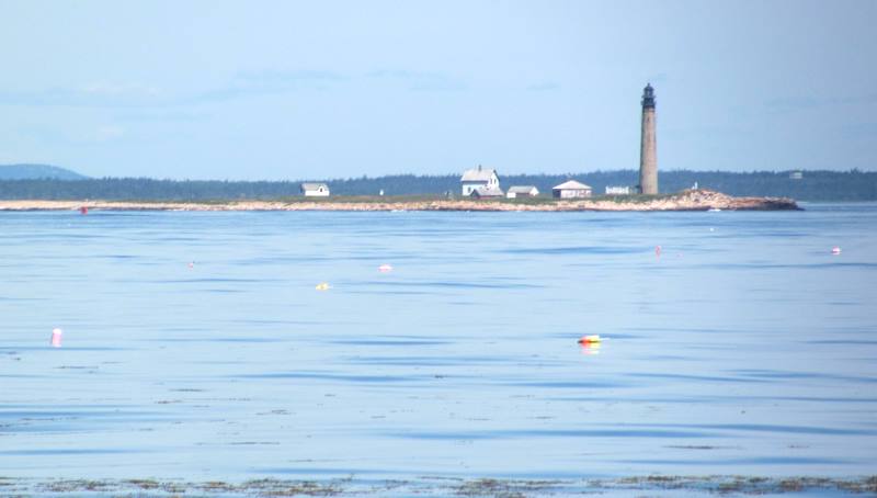
Petit Manan Light Station
")
Green Bell Number 1 near Petit Manan Lighthouse (2011)
[Petit Manan Island] The original light station on Petit Manan Island was completed in 1817, the 8th lighthouse in Maine of 66 built, and the 37th in the U.S. This first light was visible at 14 miles, used metal reflectors, and appears to have been typical of many early American lights in construction and equipment.
The Petit Manan Light was found to be both too weak and too low in focal plane (53 feet) considering the ever increasing use of the Northern. So a new light tower (the present one) with a Fresnel lens was completed in 1855, accompanied by a replacement of the buildings comprising the station. No other buildings are on the island. With a focal plane of 123 feet, the imposing granite tower has been very important, serving local fishermen and boaters and the offshore shipping and fishing industries.
")
It is the first light seen by ships from Canada or Europe using the northern shipping lanes. As such, it has guided many vessels in international traffic. It also guided coastal vessels entering five local bays during the early period of shipbuilding, timber harvest, and fishing industries. Prior to 1935 27 vessels needed assistance within sight of the light, including two captured and burned by the Confederate raider Alabama during the Civil War. Most were coastal cargo and fishing schooners.
The relatively early installation of a fog signal (1869) confirms the importance of the light and hazards of the area. In 1880, over 70% of America’s light stations had still not been so equipped. During World Wars I and II, Petit Manan was important to coastal defense as a lookout tower for foreign ships and submarines, due to its location 2 miles off the mainland.*
Wallace, Everett, House
[US Route 1 west side, .05 miles north of junction with Wyman Road] The Wallace House is a relatively unaltered Queen Anne style house. It was home to local merchant Everett W. Wallace and his wife. The existing house and garage were built in 1938, long after the popularity of the Queen Anne style had waned. The Wallaces had built a nearly identical house in the 1890s but it was destroyed by fire in 1937. They chose to recreate their long time residence in favor of adopting a contemporary architectural fashion.
Everett Wallace was a general merchant in Milbridge in 1893. By the early 1900s Wallace had also become a retail lumber dealer, and by 1913 he was one of three Black Fox breeders, an industry that flourished in Milbridge during the early 20th century. In the 1920s he operated a lobster pound. After building their house in 1938, the Wallaces are said to have rented rooms to summer tourists. They occupied the house until their deaths, after which it descended to nephew Lawrence E. Strout who was Milbridge town clerk from 1937 until 1977.
The original Wallace house was one of a several relatively large, well developed Queen Anne houses built in Milbridge during the late 19th century. The building boom reflected the community’s wealth generated from substantial ship building activity, as well as from an emerging seafood and blueberry industry.* [See photo above]