
Location Map for Lincoln Plantation
| Year | Population |
|---|---|
| 1970 | 60 |
| 1980 | 50 |
| 1990 | 38 |
| 2000 | 46 |
| 2010 | 2,041 |

Population Trend 1860-2010
| Geographic Data | |
|---|---|
| N. Latitude | 44:56:42 |
| W. Latitude | 70:59:48 |
| Maine House | District 117 |
| Maine Senate | District 18 |
| Congress | District 2 |
| Area sq. mi. | (total) 36.9 |
| Area sq. mi. | (land) 32.5 |
| Population/sq.mi. | (land) 1.4 |
| County: Oxford Total=land+water; Land=land only | |

Aziscohos Dam, June, 1973
[LINK-uhn] a plantation in Oxford County, organized on July 15, 1875 from township T5 R2 WBKP.
Though organized for election purposes in 1860, its formal organization was confirmed in 1891 by the Maine legislature.
In the 19th century, it was a magnet for summer visitors to Parmachenee Lake, a hunting and fishing resort in Parmachenee Township, north of Aziscohos Lake.
[Pronounced ah-ZISS-ca-hoss]
The Aziscohos Dam spills water into the Magalloway River that flows through the plantation. Population increased during the dam’s construction between 1909 and 1911, thus the spike in the 1910 census as shown in the chart.
")
Magalloway River (1973)
")
Magalloway River (1973)
Lincoln Plantation is just north of Magalloway Plantation, and is the last Maine township on Route 16, which then enters New Hampshire.
The southern end of Aziscohos Lake, offers campsites, a boat launch and fishing along the Lincoln Pond Road off Route 16.
Wilsons Mills is a small village with a few scattered houses and a small cemetery.
An 1851 headstone reads “Son of Eliza S. & William H Wilson, Died, December 25 1851, AE 11 Ms. 4 Ds” (age 11 months, 4 days). Several Wilsons and Ficketts were buried there in the 19th century.
 N44° 56' 27.36\" W71° 1' 50.93\"")
Wilsons Mills (2017) @
 N44° 56' 15.08\" W71° 2' 5.92\"")
Wilsons Mills (2017) @
 N44° 56' 12.18\" W71° 2' 1.64\"")
Magalloway Rafters (2017) @
 N44° 56' 13.31\" W71° 2' 2.69\"")
Wilsons Mills Cemetery (2017) @
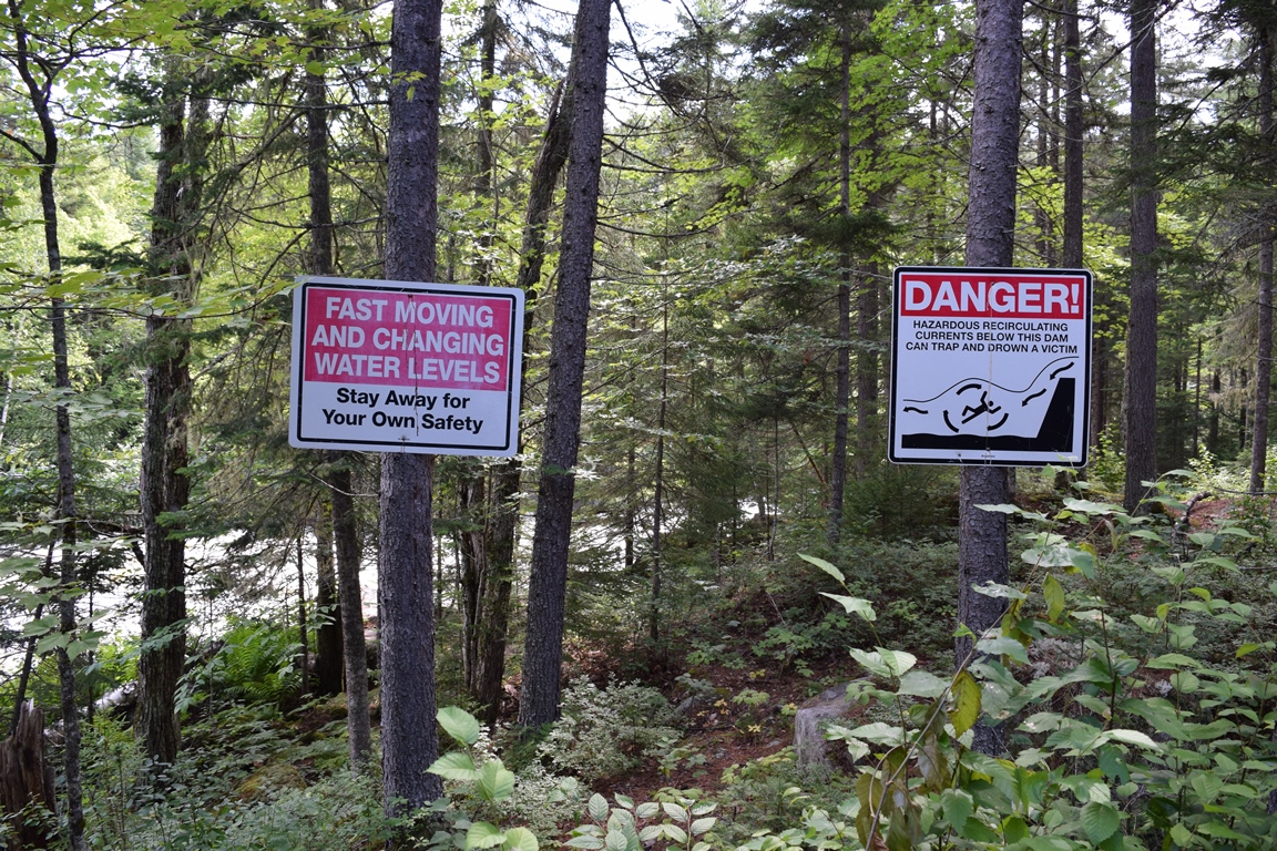
Rafters who test the challenging Magalloway River below the dam find the quiet waters of the Magalloway at Wilsons Mills a place to relax. A “take out” beyond the bridge is available, frequently with shuttle buses ready to transport raft and crew back to repeat the feat.
Water releases range from 1200 cubic feet per second, passing any stationary point on shore, to 600 cfs and 300 cfs. Slower is not necessarily safer since more rocks in the river will be exposed. See the difference in the comparison in the two similar photos below. More rafting.
 N44° 56' 38.86\" W70° 59' 57.25\"")
Aziscohos Dam (2017) @
 N44° 56' 42.06\" W70° 59' 51.01\"")
Aziscohos Dam (2017) @
 N44° 56' 42.45\" W70° 59' 43.70\"")
Aziscohos Lake (2017) @
")
Aziscohos Lake (2017)
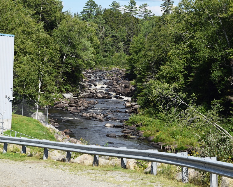
Magalloway River below Aziscohos Dam 300 cfs
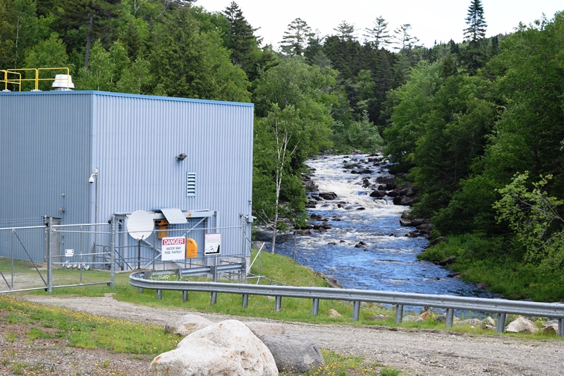
Magalloway River below Aziscohos Dam 1200 cfs
Form of Government: Assessors-Annual Meeting.
Additional resources
1973 Photos: National Archives #’s NWDNS-412-DA-8169, NWDNS-412-DA-8173, and NWDNS-412-DA-8177 respectively.
Farrar, Charles A. J. Farrar’s Illustrated Guide Book to Rangeley, Richardson, Kennebago, Umbagog, and Parmachenee lakes, the head-waters of the Connecticut, Dixville Notch, and Andover, Me., and vicinity . . . Boston. Lee and Shepard. 1882.
Farrar, Charles A. J. Wild Woods Life, or, A Trip to Parmachenee: containing The adventures of the party of Boston boys … ; a realistic story of life in the woods. Boston.Lee & Shepard. 1884. [University of Maine, Raymond H. Fogler Library, Special Collections]
Haynes, George H. Rangeley Lakes, Parmachenee, Kennebago and Seven Ponds: via Boston & Maine, Maine Central Railroad and Sandy River Railroad. 1914? (Lewiston, Me. Journal Press) [Maine State Library]
Heywood, Daniel E. Diary of Daniel E. Heywood, a Parmachenee Guide at Camp Caribou, Parmachenee Lake, Oxford Co., Maine, fall of 1890. 1984. [University of Maine, Raymond H. Fogler Library, Special Collections]
History of Wilsons Mills, Maine and the Magalloway Settlements. Wilsons Mills, Me. Published by the Town. 1975.
*Maine. Historic Preservation Commission. Augusta, Me. Text and photos from National Register of Historic Places: http://pdfhost.focus.nps.gov/docs/nrhp/text/70000055.PDF and http://pdfhost.focus.nps.gov/docs/nrhp/photos/70000055.PDF
**U.S. Department of Transportation, Federal Highway Administration. “Descriptions of FY2000 Funded Bridge Projects.” “Bennett Covered Bridge – Oxford County Maine.”
Whittemore, William. Diaries, 1870-1876. (Cataloger Note: William Whittemore was a laborer in 1870 on a farm owned by William W. Bragg in Errol, New Hampshire. His diaries, one for 1870 and one for 1875, record his work on the farm and work as a trapper along the Magalloway River in Lincoln Township, Oxford County, Maine.
Entries are brief and record the weather and work he did on the farm during the summer and logging at the Millsfield Pond dam during the winter. He also trapped animals during the winter. Included in the 1875 diary is a list of game he caught in the winter of 1875/1876.) [University of Maine, Raymond H. Fogler Library, Special Collections]
National Register of Historic Places – Listings
Bennett Bridge
[1.5 miles south of Wilson Mills off Maine Route 16, over Magalloway River, Wilsons Mills] This 1901 wooden covered bridge spans the Magalloway River as it passes near Wilsons Mills, a section of Lincoln Plantation (T5 R2 WELS) in Oxford County. The 93-foot Bennett Covered Bridge was built in 1901 and spans the Magalloway River near Wilsons Mills. It has been closed to traffic since 1985.
")
Bennett Covered Bridge, 1901 (c. 1935)
The bridge was built to serve the several small farms, which snuggle close to the New Hampshire border, on the west side of the Magalloway. A few of these farms are still occupied, but they no longer produce. Crops of hay had been raised for the feeding of horses used in winter pulp cutting and logging operations. Tractors, trucks and skidders have replaced the horse, so these fields are reverting to forests. The bridge is owned by the Maine Department of Transportation.* (Photo: George French Collection, Maine State Archives.)
Built in 1901, this is a single span 93 ft. long, 15 ft. wide Paddleford type truss bridge. It is on original alignment, and is currently open to pedestrians only. This bridge is the latest of five identified Paddleford Truss bridges built from 1857 to 1898. Previous work repaired or replaced deteriorated elements. The bridge remains composed of solid sawn and laminated timber beams, and vertical plank siding. The easterly truss is leaning downstream but has been temporarily braced by cables and steel rods secured to the ground.
")
Bennett Covered Bridge (2017)
")
Bennett Covered Bridge (2017)
The U.S. Federal Highway Administration awarded $581,404 in its year 2000 budget to assist repairs. Another $170,000 was to be raised from “other sources.” Proposed work includes restoring trusses back to plumb, replacing deteriorated elements; and replacing the metal roof with an original wooden roof.**
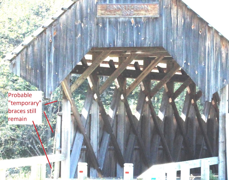
Bennett Bridge Structural Elements (2017)
However, the 2017 photos (click to enlarge) seem to indicate that none of the proposed improvements have been made.
The metal roof is obviously still in tact and apparently the “temporary” cables and rods remain.
2017 photos provided by Donna Frisoli and David I. Chipman.
Contrary to the information provided above, no portion of Aziscohos lake is in NH, it’s entirely in Maine.
Thank you for reporting that blunder! It was a misreading of the Maine Atlas and Gazetteer. The error has been corrected.