")
The Campus of Limington Historical Society (2014)

Location Map for Limington
| Year | Population |
|---|---|
| 1970 | 1,066 |
| 1980 | 2,203 |
| 1990 | 2,796 |
| 2000 | 3,403 |
| 2010 | 3,713 |
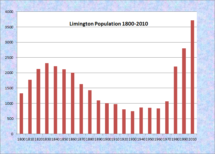
Population Trend 1800-2010
| Geographic Data | |
|---|---|
| N. Latitude | 43:44:01 |
| W. Longitude | 70:42:11 |
| Maine House | District 22 |
| Maine Senate | District 31 |
| Congress | District 1 |
| Area sq. mi. | (total) 43.3 |
| Area sq. mi. | (land) 42.0 |
| Population/sq.mi. | (land) 88.4 |
County: York
Total=land+water; Land=land only |
|
") [LIM-ing-tun] is a town in York County, incorporated on February 9, 1792 from Ossipee Plantation and was probably named for the English town in Somersetshire, the home county of Fernando Gorges.
[LIM-ing-tun] is a town in York County, incorporated on February 9, 1792 from Ossipee Plantation and was probably named for the English town in Somersetshire, the home county of Fernando Gorges.
In 1870 it ceded some land to the town of Limerick. According to George Varney in his 1886 Gazetteer of the State of Maine, the first permanent settler was Deacon Amos Chase, who arrived in 1773, followed by Ezra Davis and Jonathan Boothby in 1774. However, Maine A History, Centennial Edition, Biographical, reports that “Rev. Robert Boodey . . . in 1772 removed to Limington, Maine, where he was chosen one of the first officers of the town.”
In 1789 the First Congregational Church was organized and its first church was built in 1793. “Old Boynton,” a cannon captured from the British warship Boxer in the war of 1812 by the U.S. vessel Enterprise, sits on the Limington Library grounds in the village.
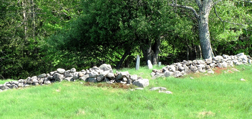
Old Cemetery with Stonewall at woods edge (2010)
Limington Academy was incorporated in 1848 having been founded by Arthur and James McArthur, Rev. J. H. Garmon, Dr. Samuel M. Bradbury, Gideon L. Moody, and Isaac L. Mitchell. It opened in 1851 in the village schoolhouse, then moved to the Masonic building. In 1854 it opened in its own building, which still stands. (more below)
The Saco River forms the town’s northern and eastern boundaries. In 1886 the Gazetteer of the State of Maine described the town’s geography thus:
The soil is fertile, and the usual crops are cultivated. The surface of the town is much broken, and there are several lofty eminences, the chief of which are Veasie, Meserve, Moody and Maloy mountains, so called, and Crockett’s Hill. Granite is abundant about the falls on the Little Ossipee. The water powers are numerous. Nason’s Falls, on Little Ossipee River, fall 60 feet in the distance of one-fourth of a mile.
The author lists several shingle, stave, grist and saw mills and a tannery using the abundant water power of the town. Limington Historical Society offers a look into the past with a small library and several other buildings containing early farm implements.

Small Library at the Historical Society
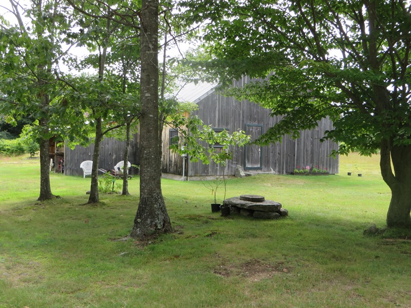
Barn at the Historical Society (2014)
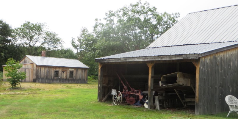
Farm implements shed and blacksmith shop (left)
")
Old Longfellow School (2010
After 200 years, the old Town Hall was replaced by a modern Municipal Complex. Primary education now takes place in the Emery Memorial School, a major change from the old Longfellow School. (right)=>
Nevertheless, the main village retains its historic character thanks to the local efforts to establish its Historic District.
Maine Routes 11, 25 and 117 crisscross the town, which is about 15 miles northwest of Gorham, in the northeastern corner of York County.
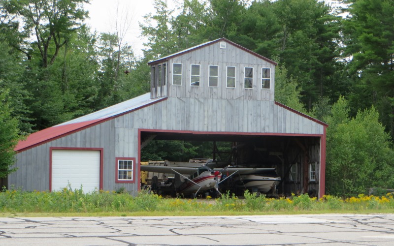
The Airport
Limington has a modest general aviation airport: that is, no scheduled commercial air travel. The Limington-Harmon Airport does have hangers for several single-engine aircraft.

Aircraft Shelters at the Airport (2014)
")
Runways and Taxi Ways at the Airport (2014)
Aircraft Hanger at the Limington Airport (2018)
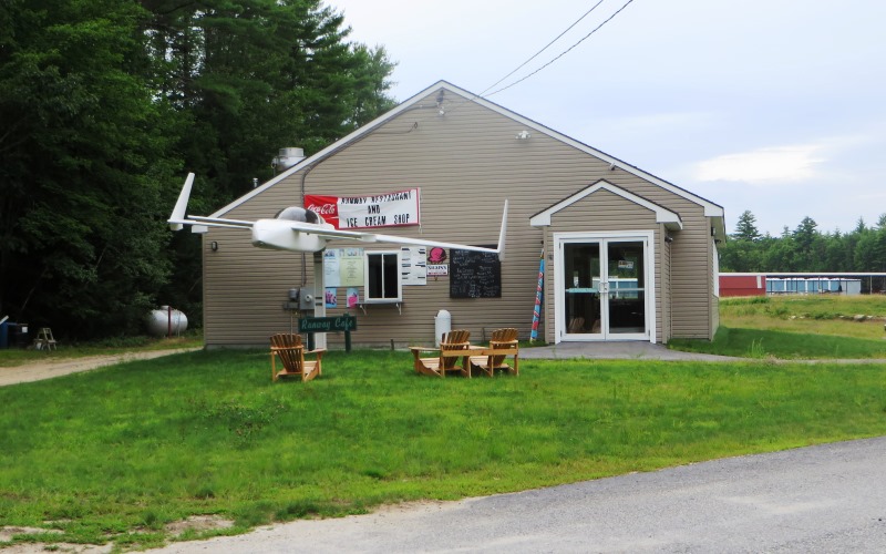
Restaurant at the Limington Airport (2014)
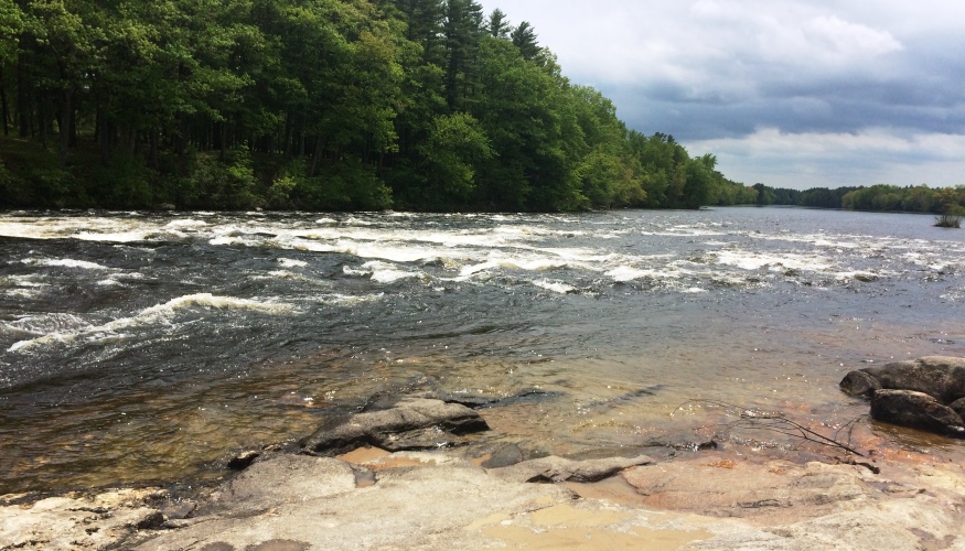
In East Limington the Saco River defines the town’s eastern boundary with Standish. After entering Maine from New Hampshire in Fryeburg, the river makes its way southeast for about 25 miles “as the crow flies.” With all its winding ways, it could be double that length “as the fish swims.” Limington Rapids Rest Area, or as the Town calls it, Limington Rips Rest Area, is “a favorite spot for wading and fishing in the Saco River. When Route 25 crosses the River from the south into Limington, the State of Maine Rest Area is on the left. (no charge; closed in winter) The “rips” are at N43° 43′ 57.60″ W70° 39′ 11.40″.

Medal of Honor
Congressional Medal of Honor Winner
ROBERT BOODY
Form of Government: Town Meeting-Select Board.
More Videos!
Additional resources
Annual Catalogue of the Officers and Students of Limington Academy, Limington, Maine. Portland, Me. Published by the Trustees. 1854-1858.
Chadbourne, Ava Harriet. Maine Place Names and The Peopling of its Towns.
Chick, Olive M. A History of Limington Academy, 1848-1948. 1948. [Thesis (M.Ed.) in Education — University of Maine, 1948]
Limington Recreation.”Limington Rips Rest Area.”http://www.limington.org/recreation.html
Maine A History, Centennial Edition, Biographical. New York. The American Historical Society. 1919. p. 190.
*Maine. Historic Preservation Commission. Augusta, Me. Text and photos from National Register of Historic Places: http://pdfhost.focus.nps.gov/docs/nrhp/text/xxxxxxxx.PDF and http://pdfhost.focus.nps.gov/docs/nrhp/photos/xxxxxxxx.PDF
Libby-MacArthur House: 88000397.PDF
Limington Academy: 80000380.PDF
Limington Historic District: 98001601.PDF
The McArthurs [MacArthurs] of Limington, Maine 1783-1917: the family in America a century ago. Ring, Elizabeth. Falmouth, Me. Kennebec River Press, Inc. 1992.
The Ossipee Valley. Images from the Cornish, Limerick, Limington, Newfield, and Parsonsfield-Porter Historical Societies. Charleston, SC. Arcadia. 2005.
Sleeper, Frank H. Buxton, Hollis and Limington. Dover, N.H. Arcadia. 1997.
Steeves, Brenda Howitson. Robert L. Taylor Collection: Guide to the Collection. Limington, Me. Davis Memorial Library. 2001.
Taylor, Robert L. History of Limington, Maine 1668-1900. Norway, Me. Oxford Hills Press. 1975.
Varney, George J. Gazetteer of the State of Maine. pp. 327-328.
National Register of Historic Places – Listings
Chase, Capt. Josiah E., Octagon House
[Chase’s Mill Road East Limington] The Captain Josiah E. Chase Octagon House is among the most architecturally significant and least altered of Maine’s twelve known surviving octagonal buildings. Its unique architectural form links the house to the theories of design espoused by Orson Squire Fowler. The house was built soon after 1858 for Chase (1819-1898), a sea captain and a member of the locally prominent Chase family.
")
Captain Josiah E., Chase Octagon House, undergoing restoration in 1986 (Kirk Mohney photo)
Orson Squire Fowler’s (1809-1887) most notable achievement was as author of A Home For All (1848). Fowler’s theories about exterior form and arrangement of interior space were radical departures from the traditional American house. Ultimately the octagon house form gained only limited acceptance. Many octagons suffered extensive later alterations. Those that survive in a relatively unaltered state assume increased significance in the history of the mid-19th century romantic movement in American architecture.
Josiah Chase, the original owner of this house had an eventful life as a mariner. Born in East Limington Chase’s father was part owner of a sawmill, at the junction of the Saco and Ossipee Rivers, a site just to the northeast of the house. At the age of eighteen Chase moved to New Bedford and made his first voyage aboard the bark “Forester”. In 1841 Chase began a three-year whaling expedition returning in 1845. After many other such expeditions, he retired from the sea in 1876 after a voyage in the ship “California”, but later returned to captain the “James Arnold”. At some point Chase married Julia Ellen Brown (1832-1915). In 1858 he acquired the property on which the house stands. At that time he he was living in Portland. After the house was built, the family apparently remained in Portland until some years before Josiah Chase’s death. The property remained in the family until 1971.
Libby-MacArthur House
") [Maine Route 11] Apparently built during the 1790s, the Libby-MacArthur House is architecturally significant as one of only a handful of early historic gambrel roofed buildings in Maine. The use of this roof form on a building of the mid-Federal period is particularly unusual. The House occupies part of the 100 acre lot drawn by Samuel Small in 1774. Small transferred it to his daughter Martha and her husband Philemon Libby (1749-1811) in 1777.
[Maine Route 11] Apparently built during the 1790s, the Libby-MacArthur House is architecturally significant as one of only a handful of early historic gambrel roofed buildings in Maine. The use of this roof form on a building of the mid-Federal period is particularly unusual. The House occupies part of the 100 acre lot drawn by Samuel Small in 1774. Small transferred it to his daughter Martha and her husband Philemon Libby (1749-1811) in 1777.
The Libbys had already made their home here, although it was a small structure, perhaps of log construction as was typical of 18th century frontier settlements in Maine. In 1836, Arthur McArthur acquired the house. A graduate of Bowdoin College (1810), MacArthur studied of law and was admitted to the bar in 1815. He began his practice in Sanford but returned to Limington in 1818 where he remained for the duration of his life.* (See photo in video, second image in the Historic District, dark, no paint.)
Limington Academy
[Maine Route 117] ") The Limington Academy Building is a Greek Revival temple style structure. Its lines make it an outstanding landmark in a rural setting. Founded by subscription in 1848, sessions of the Academy were first held in 1851 in the village district school house, then in the Masonic hall (see video) and other locations. In 1854 the building was erected.
The Limington Academy Building is a Greek Revival temple style structure. Its lines make it an outstanding landmark in a rural setting. Founded by subscription in 1848, sessions of the Academy were first held in 1851 in the village district school house, then in the Masonic hall (see video) and other locations. In 1854 the building was erected.
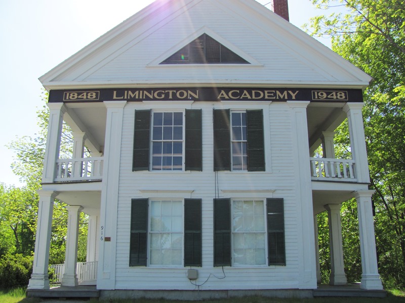 By-laws of the Academy board note that its object was “to establish an institution for the promotion of Science and Literature and wherein youth may be instructed in the higher breaches of education usually taught in the Academies of this state.” In 1895 the Academy trustees voted to accept all school-aged children of the town and a few years later it became a public high school. With a new school facility built next to it, the old building provided classroom space for elementary grades.*
Limington Historic District
[Junction of Maine Route 11 and Maine Route 117] The District (see the video above) has 24 principal buildings that constitute the historic core of Limington Village. Built primarily in the late 18th and early to mid-19th centuries along two intersecting roads, they reflect the development of a small rural Maine village that acted as a service center for the outlying community. The district includes frame buildings of one, two, and three stories. Most are residences designed in the Federal style, indicating the early settlement and growth of the village.
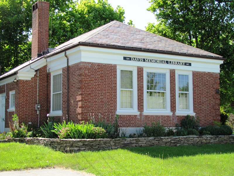
Davis Memorial Library (2010)
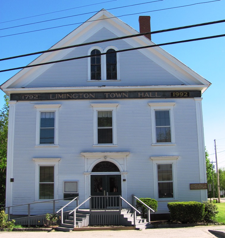
The old Limington Town Hall at the crossroads in Limington Village
Three public buildings are in the district: the old village school, the town hall, and the public library. The school is typical of such buildings in rural Maine, although it is distinguished by a Federal style bell tower with arched openings. The Italianate style town hall is a landmark not only because of its scale, but also in its location at one of the four corners formed at the intersection of Routes 11 and 117. The nearby Davis Memorial Library (see photo above) is a Colonial Revival style brick building designed by the firm of John Calvin Stevens & John Howard Stevens, the state’s leading architects.*