
Location Map for Limestone
| Year | Population |
|---|---|
| 1970 | 8,745 |
| 1980 | 8,719 |
| 1990 | 9,922 |
| 2000 | 2,361 |
| 2010 | 2,314 |

Population Trend 1860-2010
| Geographic Data | |
|---|---|
| N. Latitude | 46:54:25 |
| W. Longitude | 67:51:48 |
| Maine House | District 148 |
| Maine Senate | District 1 |
| Congress | District 2 |
| Area sq. mi. | (total) 40.7 |
| Area sq. mi. | (land) 40.4 |
| Population/sq.mi. | (land) 57.3 |
| County: Aroostook
Total=land+water; Land=land only |
|
") [LIME-stone] is a town in Aroostook County, incorporated on February 26, 1869 from Limestone Plantation, itself formally organized in 1855 from the township E R1 WELS.
[LIME-stone] is a town in Aroostook County, incorporated on February 26, 1869 from Limestone Plantation, itself formally organized in 1855 from the township E R1 WELS.
Settled in 1849 by General Mark Trafton of Bangor, then the Customs Officer at Fort Fairfield, it was named for the lime deposits found there.
As early as 1846 a dam and a shingle mill had been completed. By the 1880’s Limestone had two sawmills and two starch factories, fed by the local potato crops.
")
U.S. Customs on Route 229 (2003)
")
U.S. Post Office Limestone (2016)
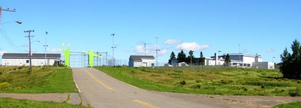
The town is a port of entry into the United States from Limestone, New Brunswick, Canada.
In the north of the town, the Aroostook National Wildlife Refuge straddles the town line with Caswell.
")
Robert A. Frost Memorial Library (2003)
The disastrous impact on the community of the demise of Loring Air Force Base in the 1990’s may be seen by Limestone’s population fluctuation:
The 2000 and 2010 censuses place the number of residents below the 1950 mark of 2,427 and far below the 1960 peak of 13,102!
")
School of Math and Science (2003)
")
School of Math and Science (2003)
The School of Mathematics and Science, a high school for top students from across the state, is located on the former military base, as is the Aroostook National Wildlife Refuge. In a ranking of 17,000 high schools in the United States, U.S. News & World Report released in April 2019, the School of Mathematics and Science ranked second (the top 1%) in the nation on a battery of academic measures.*
")
U.S. Route 1A in the Main Village (2003)
Form of Government: Town Meeting-Select Board-Manager.
Additional resources
Chadbourne, Ava Harriet. Maine Place Names and The Peopling of its Towns.
Garbinski, John C. The United States Air Force in Maine: Progeny of the Cold War. Bangor, Me. Maine Aviation Historical Society. c2000.
Limestone Centennial, 1869-1969: The Review of a Century. Limestone, Me? The Centennial Committees. 1969.
Loring Readjustment Committee (Me.) Community Profiles. Caribou, Me. The Committee. 1993.
Maine Department of Conservation. Bureau of Parks and Lands. Northern Aroostook Region Management Plan. June 2007. http://www.maine.gov/doc/parks/programs/planning/northern/plan.pdf (accessed October 17, 2011)
Maine. Trial Justice Court (Limestone). Wallace K. Fenlason, Trial Justice Docket. 1952 June 25-1957 June 11. (Cataloger Note: This docket records the Trial Justice criminal cases heard by Wallace K. Fenlason. These court records include brief notes on the case: defendant, and the Justice’s decision in the case or their appeal to the next court. Typical cases could include assault, motor vehicle violations, non-support, malicious mischief, breaking entering and larceny, etc.) [Maine State Archives]
*Russell, Eric. “What Makes this remote Maine school No. 2 in the Nation?” Maine Sunday Telegram. May 5, 2019.
Turner, Philip B. Loring. Caribou, Me.? The Author. .1994? [University of Maine, Raymond H. Fogler Library, Special Collections; University of Maine at Presque Isle Library and Learning Resource Center]
United States. Department of the Interior. National Park Service. “Church of the Advent.” https://npgallery.nps.gov/pdfhost/docs/nrhp/text/91000767.PDF (accessed February 27, 2017)
United States. Department of the Interior. National Park Service.”U.S. Inspection Station–Limestone, Maine.” https://www.nps.gov/nr/feature/places/pdfs/14000556.pdf (accessed February 27, 2017)
National Register of Historic Places – Listings
Church of the Advent
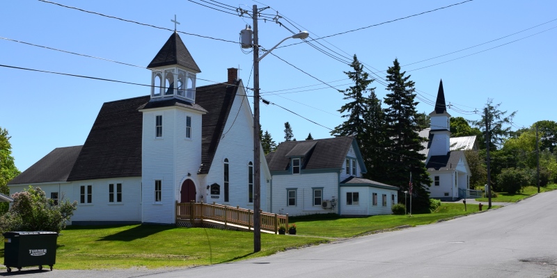 [Church Street, one block south of junction with Maine Route 229] The Church of the Advent is a small wooden building which is distinguished by a very steeply pitched gable roof and its square entrance/bell tower that is attached to one side. Weatherboards cover the entire building with the exception of the concrete block dining hall which is attached to the rear.
") Built in 1881, the Church of the Advent exhibit a combination of Gothic and Romanesque characteristics. It is particularly distinguished by the design and finish of the interior which includes a high barrel vaulted ceiling and surface treatments of narrow tongue-and-groove sheathing.The Episcopal congregation which formed the Church of the Advent in 1872 is believed to have been the first organized religious body in Limestone. At the 1870 census, Limestone, incorporated on February 26, 1869, had a population of only 268. Services were originally held in a school house with priests coming from Andover and Grand Falls, New Brunswick. By 1881 the congregation had grown to the point where a permanent religious building was considered necessary.
Built in 1881, the Church of the Advent exhibit a combination of Gothic and Romanesque characteristics. It is particularly distinguished by the design and finish of the interior which includes a high barrel vaulted ceiling and surface treatments of narrow tongue-and-groove sheathing.The Episcopal congregation which formed the Church of the Advent in 1872 is believed to have been the first organized religious body in Limestone. At the 1870 census, Limestone, incorporated on February 26, 1869, had a population of only 268. Services were originally held in a school house with priests coming from Andover and Grand Falls, New Brunswick. By 1881 the congregation had grown to the point where a permanent religious building was considered necessary.
Sometime in 1896 the congregation apparently concluded that the building’s location was too far removed from the growing village center. Attempts to move the church had foundered and the structure was left standing in the middle of the highway. Its move was finally complete in 1896.*
U.S. Inspection Station–Limestone
[N46° 55′ 27.58″ W67° 47′ 26.42″] The Station is one of the few border stations that maintain its original porte-cochere height of 9.25 feet. Most were increased from 12 feet to 14.5 feet to accommodate taller vehicles after the construction of the Interstate Highway System began in 1956. It retains important original program elements, and despite numerous alterations, continues to demonstrate the historic characteristics of Border Station MPS Property.
")
U.S. Inspection Station (2016)
")
Canadian Inspection Station (2016)
Limestone retains the attributes necessary to convey that it was one of the first set of purpose-built U.S. Border Inspection Stations that were planned, designed and constructed by the U.S. Government to improve land border security. Built in 1933, it was sited alongside a border highway, State Route 229, at one of the locations recommended in 1928 by H.A. Benner of the Bureau of Customs and J.L. Hughes of the Bureau of Immigration. Its construction was in direct response to a chain of events including the imposition of head taxes and country quotas on immigration in 1917 and 1921, smuggling arising from the prohibition of alcohol in 1919, and the increase in usage of the automobile and improved roads in the 1920s.*