")
Webb River entering the Androscoggin in Dixfield Village (2013)

Location Map for Dixfield
| Year | Population |
|---|---|
| 1970 | 2,188 |
| 1980 | 2,389 |
| 1990 | 2,574 |
| 2000 | 2,514 |
| 2010 | 2,550 |
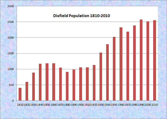
Population Trend 1810-2010
| Geographic Data | |
|---|---|
| N. Latitude | 44:32:24 |
| W. Latitude | 70:23:01 |
| Maine House | District 116 |
| Maine Senate | District 18 |
| Congress | District 2 |
| Area sq. mi. | (total) 41.6 |
| Area sq. mi. | (land) 41.2 |
| Population/sq.mi. | (land) 61.9 |
County: Oxford
Total=land+water; Land=land only |
|
")
Veterans Memorial in East Dixfield (2010)
[DIX-field] a town in Oxford County, incorporated on June 21, 1803 from a portion of the Holman Grant.
Dr. Elijah Dix, a substantial landowner in the area, bought the town (and Dixmont) which bears his name.
He allegedly promised to establish a library if the town were named after him. Afterwards, he sent a set of old medical books and some dictionaries, to the consternation of the towns people.

Dixfield Birdseye View 1896
Dr. Dix’s son, Joseph, lived in Hampden where Joseph’s daughter, the future social reformer, Dorothea Lynde Dix was born in 1802.
The Webb River forms the line between Dixfield and Mexico.
It rises from the brooks in Weld, through the wetlands in Carthage, to meet the Androscoggin at Dixfield Village.
Dixfield Village, on combined routes U.S. 2 and Maine 17 and intersecting with Route 142, is clearly the main village of the town.
It contains both civic and commercial amenities, including schools and other public buildings. Dixfield had one of the recommended “travel homes” in the post World War II guide “The Negro Travelers’ Green Book.” In this case, it was the Marigold Motel on U.S. Route 2, approximately 10 miles east of Rumford, that served African Americans when many others did not.
 N44° 32' 25.35\" W70° 27' 11.42\"")
Dirigo High School (2013) @
 N44° 32' 20.08\" W70° 27' 13.50\"")
Dr. G. G. Defoe Gym (2013) @
 N44° 32' 58.03\" W70° 27' 9.83\"")
Kelly Dirigo Mid. School (’13) @
 N44° 31' 51.87\" W70° 27' 23.94\"")
Bank and Houses (2013) @
 N44° 31' 52.18\" W70° 27' 25.21\"")
Stores and Gas Station (2013) @
 N44° 31' 52.30\" W70° 27' 21.03\"")
Post Office/Town Office ’13 @
 N44° 31' 51.47\" W70° 27' 20.84\"")
Fire Department (2013) @
 N44° 31' 51.58\" W70° 27' 20.92\"")
Ludden Library (2013) @
Inventor Leonard Norcross was a resident of the town in the early 19th century. According to Isaacson, “In 1834 Leonard Norcross invented and patented a type of ‘diving armor’ that utilized Goodyear’s invention of India rubber cloth. Old newspaper articles say the Norcross diving outfits were used in raising the Russian fleet sunk off Sebastopol in the Crimean War and in cleaning gunboats in Civil War times.”
Dixfield had one of the recommended “travel homes” in the post World War II guide “The Negro Travelers’ Green Book.” In this case, it was the Marigold Motel on U.S. Route 2, approximately 10 miles east of Rumford, that served African Americans when many others did not.
 N44° 34' 28.60\" W70° 18' 28.45\"")
Former School in East Dixfield (2013) @
 N44° 34' 22.97\" W70° 18' 7.91\"")
Mystic Valley Grange in East Dixfield (2013) @
 N44° 34' 23.26\" W70° 18' 7.72\"")
East Dixfield Fire Department (2013) @
")
Post Office in East Dixfield (2010)
")
United Baptist Church in East Dixfield (2010)
Form of Government: Town Meeting-Select Board-Manager.
More Videos!
Additional resources
Image credit: “Dixfield Birdseye View 1896.” LC classification: G3734.D5A3 1896 .D5. Repository: Library of Congress Geography and Map Division Washington, D.C. 20540-4650 USA dcu. Digital ID: G3734D Pm002433 Http://Hdl.Loc.Gov/Loc.Gmd/G3734D.Pm002433. Image source: http://www.loc.gov/item/91685205 (accessed March 18, 2013)
Daybook, 1850-1866. (Cataloger Note: A daybook of a farmer who probably lived in Dixfield, Maine. Listed are goods and services bought and sold from 1850 to 1866.) [University of Maine, Raymond H. Fogler Library, Special Collections]
Dixfield Bicentennial Committee. The Early History of Dixfield Maine: including the section of Mexico near Webb’s River. Dixfield, Me. The Dixfield Historical Society. 1976.
Isaacson, Dorris, ed. Maine: A Guide Downeast.
Stowell, Peter Russell. Frank Stanley’s Scrapbook: from July 13, 1873 to July 18, 1947. Dixfield, Me. Dixfield Historical Society. 2003. (Cataloger Note: “On July 13, 1873, twenty-five year-old Frank Stanley began a scrapbook of newspaper clippings, many of them relating to his family and to community life in Dixfield…Altogether, the clippings span a period of nearly seventy-five years, ending in July 1947”–[Pref.]) [Maine State Library]
Town of Dixfield, Maine: Bicentennial Memories: June 21, 1803-2003. Dixfield, Me. Bicentennial Committee. Dixfield Town Office. 2003. [University of Maine, Raymond H. Fogler Library, Special Collections]
Does anyone have any history on the old Tom Ellis house on the Canton Point Road? This property is on the market. This house was in my family for about 15 years. I am looking for information about it being a stop over in the early days when people were traveling by horse and carriage.