“There is something about it that opens no door to words.”
— Steinbeck

Location Map for Deer Isle
| Year | Population |
|---|---|
| 1970 | 1,211 |
| 1980 | 1,492 |
| 1990 | 1,829 |
| 2000 | 1,876 |
| 2010 | 1,975 |
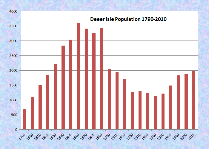
Population Trend 1790-2010
| Geographic Data | |
|---|---|
| N. Latitude | 44:13:43 |
| W. Longitude | 68:42:46 |
| Maine House | District 134 |
| Maine Senate | District 7 |
| Congress | District 2 |
| Area sq. mi. | (total) 123.7 |
| Area sq. mi. | (land) 29.7 |
| Population/sq.mi. | (land) 66.5 |
| County: Hancock
Total=land+water; Land=land only |
|
")
Deer Isle (NOAA 13202-1996)
")
Deer Isle Bridge from Sedgwick, c. 1940 (George French, Maine State Archives)
")
Deer Isle Bridge from Little Deer Isle (2003)
")
[deer ISLE] is a town in Hancock County, incorporated on February 2, 1789 from Deer Isle Plantation. Much later it set off land to form the towns of Stonington (1897) at the southern tip of the island of Deer Isle, and Isle au Haut (1874), an off shore island.
Settled in 1762, one of it’s notable early residents was the Reverend Peter Powers (1728-1800), first regular minister of the Congregational Church (1785-1800) and a fervent revolutionary. A 1965 monument to him recites his contributions:
")
Rev. Powers Plaque (2003)
Distinguished Clergyman Courageous Pioneer
Eminent Scholar
FEARLESS LEADER FOR THE CAUSE OF AMERICAN INDEPENDENCE, HE WAS FIRED UPON BY THE TORIES AFTER PREACHING TWO HISTORIC SERMONS, “TYRANNY” AND “TORYISM EXPOSED.” SEPTEMBER 10, 1780, AT NEWBURY, VERMONT, A PRICE WAS SET UPON HIS HEAD AND HIS ASSASSINATION ORDERED. ALTHOUGH SEVERELY PERSECUTED, HE CONTINUED TO PROMOTE THE CAUSE OF LIBERTY, FIRING THE COLONISTS TO NEW RESISTANCE. FIVE SONS AND FIVE BROTHERS BORE ARMS AND SERVED WITH HONOR AND DISTINCTION IN THE CONTINENTAL ARMY.
A GRADUATE OF HARVARD, A.B., A.M., HE HELPED TO FOUND DARTMOUTH COLLEGE, WHERE HE RECEIVED AN HONORARY A.M. DEGREE. HE PIONEERED THE ESTABLISHMENT OF NUMEROUS CHURCHES THROUGHOUT NEW ENGLAND AT GREAT PERSONAL AND PHYSICAL SACRIFICE AND GAVE THE FIRST ELECTION SERMON TO THE FIRST LEGISLATURE OF VERMONT IN 1778. HE WAS THE FIRST SETTLED PASTOR OF DEER ISLE, MAINE IN 1785, WHERE HE SERVED UNTIL HIS DEATH IN 1800.
")
Causeway Linking Little Deer Isle and Deer Isle (2003)
The town of Deer Isle occupies the northern two-thirds of the island of Deer Isle and all of Little Deer Isle. The Town of Stonington sits on the southern end of Deer Isle.
An amateur film from the archives of Northeast Historic Film offers a view of both towns in the 1940s.
The Deer Isle-Sedgwick Bridge, which can be see from Sedgwick, is a spectacular suspension structure arching over Eggemoggin Reach, which separates the island from the mainland. It was constructed in 1938 and opened to traffic in 1939. Its main span is 1080 feet long, while the two side spans are 484 feet in length. With 100-foot approach span on each side, the total length is 2,248 feet. Originally, the deck was supported only by vertical hangers from the main cables. Later additional bracing was added to increase resistance to the wind.
In 1960, John Steinbeck described it thus:
First, there was a very high iron bridge, as high-arched as a rainbow, and after a bit of low stone bridge built in the shape of an S-curve [the causeway], and I was on Deer Isle. . . .
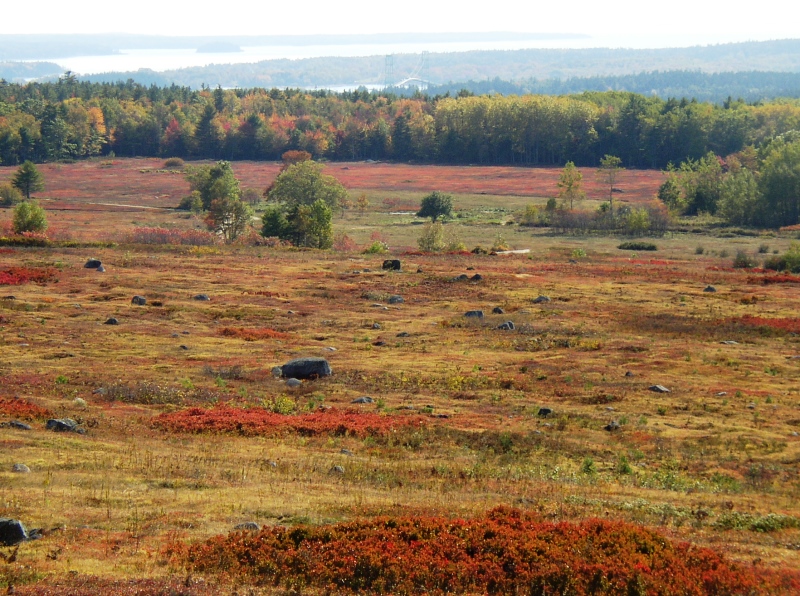
There is something about [Deer Isle] that opens no door to words. But it stays with you afterward, and, more than that, things you didn’t know you saw come back to you after you have left. One thing I remember very clearly. It might have been caused by the season with a quality of light, or the autumn clarity. Everything stood out separate from everything else, a rock, a rounded lump of sea-polished driftwood on a beach, a roof line.
")
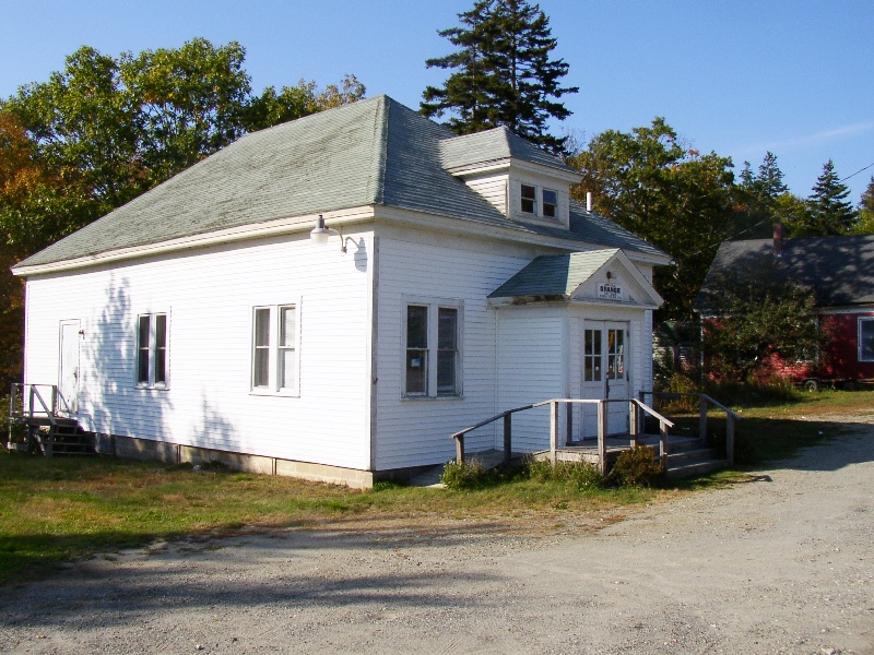
Rear View of Chapel, Masonic Hall, and High School (2003)
")
Front View: Community Buildings (2003)
Barred Island nature preserve, managed by The Nature Conservancy, is a .2 acre island with spruce-fir and shrub-cover and extensive granite shore ledges. Accessible by landing on inter-tidal sandbar or across private property with permission of Goose Cove Lodge owners, the island has no trails though one may walk along the shore. Little Eaton Island is also a sanctuary managed by the Conservancy. The Town of Deer Isle has 77 coastal islands including rock outcrops, ledges, and the large 100-acre Conary Island.
At Northwest Harbor, the Island of Deer Isle is almost split in two. The remaining narrow land area, at the village, is known as the “Haulover,” used by Indians and white settlers alike. The huge buildings below are located in the village on Route 15 in its “Historic Harbor District.” The district encompasses over twenty named structures.
More Videos!
Deer Isle Grange (2003)
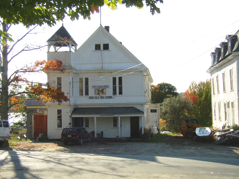
Old Deer Isle High School (2003)
")
Deer Isle Library (2003)


Form of Government: Town Meeting-Select Board.
Additional resources
Deer Isle and Stonington. The Deer Isle-Stonington Historical Society. Charleston, SC Arcadia Publishing. 2004.
Deer Isle Comprehensive Plan: November 2006. http://www.hcpcme.org/deerisle/DICompPlan1106.pdf (accessed May 28, 2011) Includes a town history.
Deer Isle Conservation Commission (Me.). Wild Flowering Plants of Deer Isle. Deer Isle. Deer Isle, Me. Deer Isle Conservation Commission. c1996.
Gross, Clayton H. Steel over Eggemoggin: a History of the Deer Isle-Sedgwick Bridge. Stonington, Me. Penobscot Books. c1989.
Hooke, Roger LeB. A Geologic History of Deer Isle, Maine: a Thumb Nail Sketch. 2003. University of Maine, Orono, Special Collections, Raymond H. Fogler Library.
Hosmer, George L. An Historical Sketch Of The Town Of Deer Isle, Maine: With Notices Of Its Settlers And Early Inhabitants. Sunset, Me. Deer Isle-Stonington Historical Society. 1983.
*Maine. Historic Preservation Commission. Augusta, Me. Text and photos from National Register of Historic Places: http://pdfhost.focus.nps.gov/docs/nrhp/text/xxxxxxxx.PDF and http://pdfhost.focus.nps.gov/docs/nrhp/photos/xxxxxxxx.PDF
Marsh, D. W. et al. “Analysis of Wind and Wind Effects Revisited – A Case Study of the Deer Isle-Sedgwick Bridge” NIST SP 931. Gaithersburg, MD: National Institute of Standards and Technology. August, 1998.
Rittenhouse, Caroline Smith. An Island Woman: Salome Sylvester Sellers, Deer Isle, Maine, 1800-1909. Stonington, ME Peg Mitten Press. [1998?]
Steinbeck, John. Travels with Charley, pp. 50, 54.
National Register of Historic Places – Listings
Photos, and edited text are from nominations to the National Register of Historic Places researched by Maine. Historic Preservation Commission.
Full text and photos are at https://npgallery.nps.gov/nrhp
Haskell, Squire Ignatius, House
")
Haskell House (1977)
[Maine Route 172A] This classic example of a post-colonial gambrel roofed house was built in 1793 by Squire Ignatius Haskell, one of the foremost men on Deer Isle in his time. It is the third oldest and only “grand house” remaining on Deer Isle. Haskell (1751-1842) came to Deer Isle from Newburyport, Massachusetts in 1778 with his father, Capt. Mark Haskell, and his brother, Solomon. They developed a varied enterprise including grist and saw mills, house construction, and a store. Operating as “Messrs. Mark Haskell and Sons”, they built several vessels including brigs, schooners, and one ship of 400 tons,and accumulated substantial property holdings.
")
Haskell House (1977)
Solomon returned to Newburyport and, after his father’s death in 1810, Ignatius took over the businesses, that now included the coastal trade. As an indication of his standing in the community, he was one of the first justices of the peace, served many-years as selectman, was twice elected to the Massachusetts General Court and, although an opponent of Maine statehood, was chosen a delegate to the state constitutional convention in 1819. He also built a meetinghouse (no longer standing) for the community, largely at his own expense.
Haskell House interior (1977)Shortly after his second marriage in 1791 to Mary Stickney of Newburyport, he began the large gambrel roof house by the mill pond. His wife, from a family of some wealth and prominence, wanted a house like those to which she had become accustomed. As a result the overall size and interior spaces of the structure far exceed those of the usual home on Deer Isle. The two principal front rooms are longer and higher than in most Maine houses of the period and location, and the central hall is generously wide. At his death he left the largest property of anyone up to that time in Deer Isle. The house remained in the Haskell family until the 1940s, often as a summer hotel and known as “The Ark”. After years of disuse, it opened again and is still operating as Pilgrim’s Inn in 2018.* [Frank A. Beard photos]
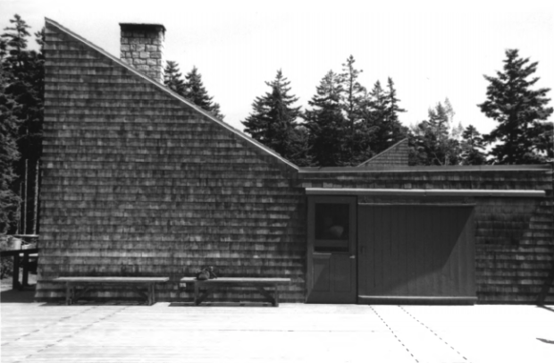
Haystack Mountain School of Crafts
[Haystack School Drive] The Haystack Mountain School of Crafts in Deer Isle is complex of wooden buildings designed by New York architect Edward Larrabee Barnes starting in 1959. The complex contains craft studios, bunkhouses, administration buildings, and a dining facility. It floats above a steep hillside overlooking Jericho Bay and the Deer Isle Thoroughfare.
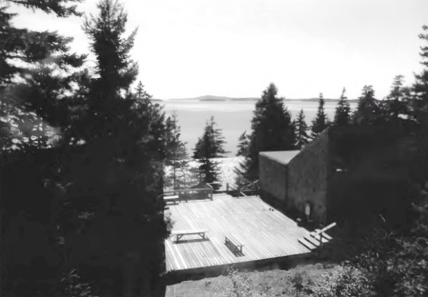
The campus reflects traditions of local architecture. At the same time the complex was recognized as an outstanding example of Modernist architecture by the American Institute of Architects in 1994. Described as a property that “has acquired the status of a New England classic,” the Haystack Campus is cited as among Barnes’ greatest achievements. This historic district of over 35 buildings and structures is significant for its architectural achievement.
The School was founded in 1950 by a group of craft artists, supported by Mary Beasom Bishop, near Haystack Mountain in Montville. The school offers intensive studio-based workshops in a variety of craft media including clay, glass, metals, paper, black smithing, weaving, and woodworking. Over the past 50 years, the school has created international workshops and conferences, held innovative sessions for high school students and local residents, and established a visiting artists program. The original campus was located on an old farmstead and first consisted of a lodge, print shop, pottery shed and a farmhouse that was turned into a wood shop. In the late 1950s the school was uprooted when a new state highway was planned through the campus.
Land was located on Deer Isle, and the school hired well known Edward Larrabee Barnes to design the new campus. From the original 26 buildings, the Haystack campus has grown with the addition of a few bunk houses and ancillary structures (kiln decks, maintenance building). Some of the studios have been enlarged, and glass blowing facilities installed. [B&W Photos by Christi A. Mitchell (August 4, 2005)]
Olmsted, Frederick Law, Summer Home
")
Olmsted Summer Home (1976)
[Southwest of Sunset on Deer Isle Sunset] The seacoast of Maine was the ideal site for “Felsted” the summer home of Frederick Law Olmsted during his declining years. Olmsted had made his career as the landscape architect of many of the nation’s city park systems, national parks, and several college campuses. Born in Hartford in 1822, Olmsted, during his childhood, traveled with his family on many trips throughout the Northeast. He studied engineering for two years then went into farming and later publishing in New York.
He continued to travel, first throughout Europe in 1850, observing and discussing his impressions of parks and gardens. He then traveled to the southern United States in 1852 on a commission from the New York Times and produced the most complete philosophical accounts ever published of the condition of the slave states. These accounts were made into three books which later were condensed into The Cotton Kingdom published in 1861. Olmsted’s unusual background of engineering and farming and his involvement in local and county affairs, as well as his dabbling in home landscaping and a modest nursery business was of major significance in the preparation for his career as a landscape architect.
His career began in 1857 with his appointment to the position of superintendent of Central Park in New York City. This was the first of the many park systems he designed such as the Back Bay area of Boston, and the grounds of the Capital Building in Washington, D.C. He also laid out Yosemite State Reservation in Wyoming and the grounds of the Vanderbilt Estate. during his childhood, traveled with his family on many trips throughout the Northeast which nurtured his interest in nature, people, and places.
Olmsted was involved with the establishment of the Maine Agricultural College at Orono. He not only drew up plans for the physical layout of the school, but offered suggestions concerning the type of curriculum to be taught. Olmsted believed the college should provide young men with a liberal education without making them unfit for an industrial calling. His plans however, laid too much emphasis on required military training and therefore were rejected by the board of trustees.
")
Olmsted Summer Home (1976)
The building of “Felsted” was initiated by Olmsted’s wife, Mary. At the time of the decision, Mary was in England with her husband. The mild, damp climate was prescribed as a possible cure for Olmsted’s failing mind. Finding Olmsted more depressed in England, Mary instructed her sons to have a year round cottage built on Deer Isle as a retirement home. Frederick Jr. hired William Ralph Emerson to design the cottage and arrange for small landscape work to be in continual progress to occupy his father. After becoming familiar with Olmsted’s work one can clearly see why the choice was made to have a Shingle Style house built by Emerson as his summer residence. Olmsted had recommended this type of house in his design for the community of Cushing Island. He moved in to “Felsted” in 1897, but he was not happy there. His mind had so failed that in 1898 his family was forced to commit him to McLean Hospital in Waverly, Massachusetts, where he remained until his death.* [Frank A. Beard photos]
Powers, Peter, House
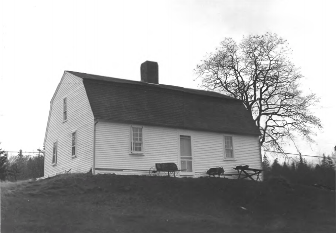
Deer Isle Powers House (1977)
[Maine Route 15 and Sunshine Road] In 1785 the First Congregational Church of Deer Isle, which had originally gathered in 1773, issued a call to Rev. Peter Powers of Newbury, Vermont, to become their first settled minister. Powers, New Hampshire born and a Harvard graduate, had been among the founders of Dartmouth College in 1769. The call included an offer of 100 pounds annual stipend, 100 acres from the 400 acre ministerial grant established by the General Court of Massachusetts, together with a house, 20 by 32 feet to be built thereon “in such manner as such buildings are commonly finished in country towns”.
") Mr. Powers, a strong and outspoken supporter of independence who had largely alienated himself from his predominantly Tory parish in Vermont, accepted with enthusiasm. He moved into his snug new house and served his Deer Isle flock faithfully until his death in 1800. This small house, the oldest in Deer Isle still intact, is particularly unusual in having a gambrel roof, rare in Maine and especially on a Cape. The extreme simplicity of the interior attests to its authenticity as an early rural home. The house is very well preserved, featuring two principal rooms on each floor and original fireplaces. As with the exterior, function dominates over decoration.* [Frank A. Beard photos]
Mr. Powers, a strong and outspoken supporter of independence who had largely alienated himself from his predominantly Tory parish in Vermont, accepted with enthusiasm. He moved into his snug new house and served his Deer Isle flock faithfully until his death in 1800. This small house, the oldest in Deer Isle still intact, is particularly unusual in having a gambrel roof, rare in Maine and especially on a Cape. The extreme simplicity of the interior attests to its authenticity as an early rural home. The house is very well preserved, featuring two principal rooms on each floor and original fireplaces. As with the exterior, function dominates over decoration.* [Frank A. Beard photos]
Pumpkin Island Light Station
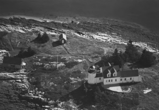
Pumpkin Island Light (1987)
[Pumpkin Island, on Little Deer Isle, Eggemoggin Reach] Pumpkin Island Light Station, established in 1854, was built as a guide to the western entrance of Eggemoggin Reach, a narrow body of water that separates Little Deer Isle from the mainland. The light station on Pumpkin Island was an integral component of a six unit system of primary navigational aids in East Penobscot Bay. All but two of these stations were built during the 1850s and after the organization of the Lighthouse Board. Located at the western end of Eggemoggin Reach, the Pumpkin Island light provided a guide to this heavily trafficked waterway linking Blue Hill Bay to the east and Penobscot Bay to the west. A dry ledge beacon replaced the station in 1934, and the property was sold to a private citizen. [Kirk F. Mohney photo]
Sellers, Salome, House
")
Sellers House (1982)
[South of Deer Isle on Maine Route 172] The Salome Sellers House is an excellent example of a well preserved Cape Cod farmhouse, and one readily accessible to the public through the Deer Isle-Stonington Historical Society, which operates it as a house-museum. The house is also notable as the home of Salome Sellers, a woman with the rare distinction of haying lived one
hundred and eight years 1800-1908.
")
The house’s ell was built between 1772 and 1817, and the frame of the main house was built adjoining it in 1830 by a carpenter named Judkins. The owner, Joseph Sellers, had cut the timbers some years before, and did the clapboarding, shingling, and flooring after the frame had been raised. The windows, of hand blown glass, were installed in 1832 and 1834.
 interior with fireplace")
The house retains virtually all of its original features, including the glass panes, pine board floors, simple mantel pieces, and door moldings (Greek Revival door moldings in parlor), Dutch oven, and curving staircase. Period furniture completes the interior. The house is Maine’s only early 19th-century Cape Cod farmhouse operated as a museum by a non-profit organisation. The house is unusual in having remained in the same family for 143 years (1817-1961), being inhabited for the bulk of those years by Salome Sellers, the most long-lived of Deer Isle’s recorded residents. ”Aunt” Salome” had become a local folk figure well before her death in 1908.* [Frank A. Beard photos]
Pond Island Archaeological District, Address Restricted