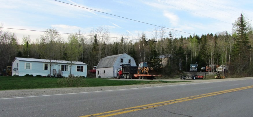
House in Codyville with Trucks and Equipment along Route 6 (2013)

Location Map For Codyville
| Year | Population |
|---|---|
| 1970 | 45 |
| 1980 | 43 |
| 1990 | 35 |
| 2000 | 19 |
| 2010 | 24 |
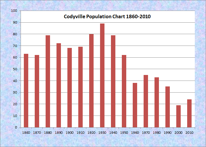
Population Trend 1860-2010
| Geographic Data | |
|---|---|
| N. Latitude | 45:28:08 |
| W. Longitude | 67:39:53 |
| Maine House | District 141 |
| Maine Senate | District 6 |
| Congress | District 2 |
| Area sq. mi. | (total) 55.1 |
| Area sq. mi. | (land) 54.8 |
| Population/sq.mi. | (land) 0.4 |
County: Washington
Total=land+water; Land=land only |
|
[CODEE-vil] is a plantation in Washington County reorganized formally on May 29, 1871 after having been organized in 1845 “for election purposes” from T9 R2 township.
According to Jim Brunelle, the plantation was formed from a Hingham Academy grant and named for its first settler. Codyville village is only about three miles east of the larger (200+ population) Topsfield village on Route 6.
This heavily forested area is subject to the 2009 Eastern Interior Region Management Plan of the Maine Department of Conservation’s Bureau of Parks and Lands. The Plan notes
The Eastern Interior region is characterized by relatively young mixed wood forests with a history of fire, [spruce] budworm damage, and timber harvesting. Forests on the state-owned parcels are 50% softwood, 31% mixed-wood, and 19% hardwood. . . . Forest types on the state-owned lands . . . [include] pockets of semi-rich hardwoods in Codyville . . . .
There is also a “substantial sedge meadow on the Codyville Public Lot.
Never even a modest sized community, recent population losses may threaten the plantation’s ability to survive. Maine Route 6 links the settlement to Vanceboro on the Canadian Border.
U. S. Census data for 2010, other than population, is apparently based on estimates. The number of employed people was reported as seven with two more unemployed. Four of the employed are in “service” occupations, and three in “Production, transportation, and material moving occupations.” Because of the small population, income estimates had very large margins of error.
The photos shown here were taken from Route 6. These residences could very well represent half the population of the town.
 N45° 32' 39.20\" W67° 31' 44.02\"")
Mobile Homes at RR Crossing along Rt. 6 (’13) @
 N45° 32' 46.10\" W67° 31' 44.60\"")
Houses along Route 6 (2013) @
Form of Government: Town Meeting-Select Board.
Additional resources
Maine Department of Conservation. Bureau of Parks and Lands. Eastern Interior Region Management Plan 2009. http://www.maine.gov/doc/parks/programs/planning/eastern/documents/IntrothroughPlanningContext.pdf (accessed October 24, 2011)
U.S. Bureau of Census. “Community Facts. Codyville plantation, Washington County, Maine.” http://factfinder2.census.gov/faces/tableservices/jsf/pages/productview.xhtml?pid=ACS_11_5YR_DP03 (accessed My 19, 2013)
</body
Are there homes for sale here ?