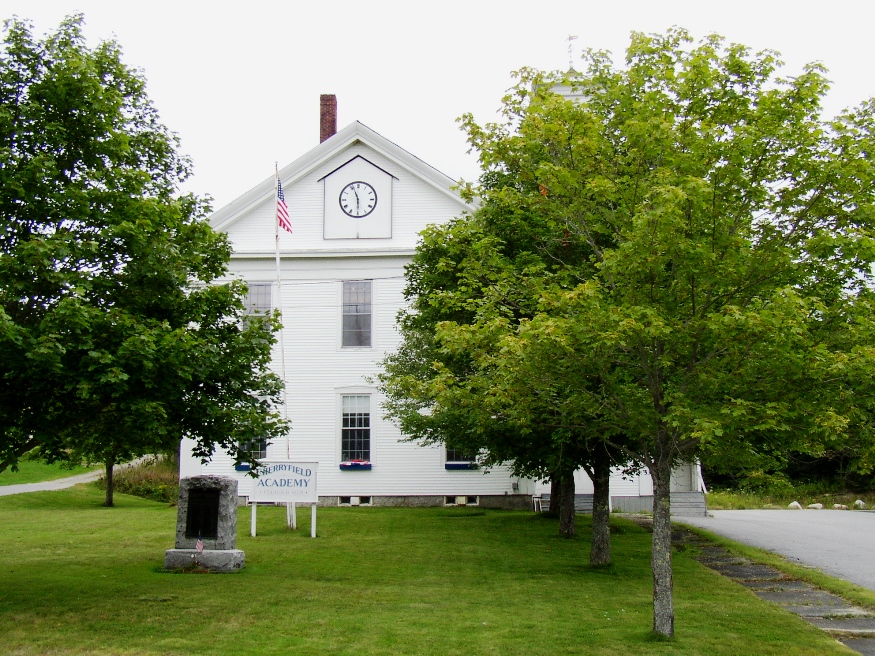
1850 Cherryfield Academy building, with a veterans memorial (2004)

Location Map For Cherryfield
| Year | Population |
|---|---|
| 1970 | 771 |
| 1980 | 983 |
| 1990 | 1,183 |
| 2000 | 1,157 |
| 2010 | 1,232 |
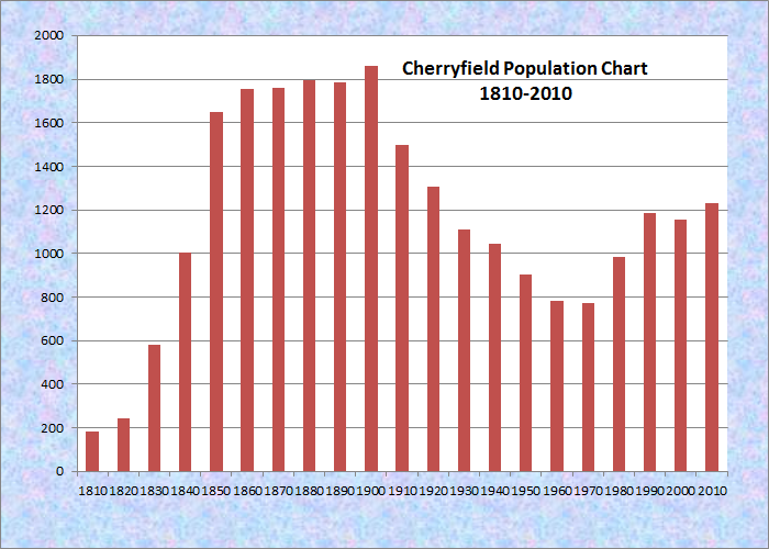
Population Trend 1810-2010
| Geographic Data | |
|---|---|
| N. Latitude | 44:37:58 |
| W. Longitude | 67:56:54 |
| Maine House | District 138 |
| Maine Senate | District 6 |
| Congress | District 2 |
| Area sq. mi. | (total) 44.3 |
| Area sq. mi. | (land) 43.7 |
| Population/sq.mi. | (land) 28.2 |
County: Washington
Total=land+water; Land=land onl |
|
")
[CHERRY-field] a town in Washington County, was incorporated on February 9, 1816 from Plantation 11 SD, BPP. It later annexed land from Steuben (1826) and Columbia (1881).
")
1st Baptist Church (2004)
Cherryfield, then called Narraguagus for the River running through it, was settled originally in 1757 by Ichabod Willey and Samuel Colson. In the 19th century, Cherryfield was on the stage coach line between Machias and Bangor. Narraguagus in Abenaki means “above the boggy place.” One of Maine’s Wildlife Management Areas, Narraguagus WMA, is east of the river and is described as “Primarily upland forests; some riverine wetlands.”
According to George Varney,
The first meeting-house was built on the east side of the [Narraguagus] river, near the Campbell mill. Cherryfield Academy was incorporated in 1829, and present [1881] Academy building was erected in 1850. . . . The town has ten public schoolhouses.
")
The Village Across the Narraguagus River (2004)
")
Cherryfield Academy (2004)
Encompassing both sides of the Narraguagus River, joined by its West Branch just west of the Village, Cherryfield was once a favorite spot for catching the now endangered Atlantic Salmon. The Narraguagus Wildlife Management Area lies between the West Branch and the main stream of the river.
Formerly a shipbuilding community, it produced the bark Belgrade, which rounded Cape Horn with 56 local men in the days of the California gold rush. Varney notes, “Vessels ascend to Milbridge, within 5½ miles of Cherryfield Village, and lumber is floated to that point in scows and rafts. The river is open to navigation eight and one-half months of the year.”
As the family farm lost self-sufficiency by 1900, specialization in poultry and dairy farming occurred on a limited basis. By 1920, many family farms and fallow lands were consolidated by large landholders and put into blueberry production.
")
Railroad Station, Main Street, not its original location (2004)
Cherryfield’s claim to be “ The Blueberry Capital of the World” is based upon its extensive blueberry barrens, which also support the canning facilities operated, by Cherryfield Foods and Jasper Wyman and Son, located on Main Street. Both factories also receive and process berries from other parts of the county and the state.
The main village lies at the intersection of U.S. Route 1 and Maine Routes 182 and 193 (Main Street) in the heart of blueberry country.
Carleton Carl Willey was born here in 1931 and went on to play baseball for the Milwaukee Braves (1958-1962) and the New York Mets (1963-1965). As a pitcher he won 38 and lost 58, with an earned run average of 3.76.
Form of Government: Town Meeting-Select Board-Administrative Assistant.
More Videos!
Additional resources
Cherryfield, Town of. Cherryfield Comprehensive Plan. Cherryfield, Me. 2004. http://www.wccog.net/cherryfield-comprehensive-plan.htm (accessed March 5, 2014)
Dedication of the Soldiers’ Monument at Cherryfield, Maine, July 4, 1874. Portland, Bailey & Noyes, 1874.
First Congregational Church, Cherryfield, Me. 150th anniversary, 1833-1983. Cherryfield, Me. The Church. 1983
Harriman, Phil. Mills of the Narraguagus. Cherryfield, Me. Cherryfield-Narraguagus Historical Society. 1977.
*Maine. Historic Preservation Commission. Augusta, Me. Text and photos from National Register of Historic Places: http://pdfhost.focus.nps.gov/docs/nrhp/text/xxxxxxxx.PDF and http://pdfhost.focus.nps.gov/docs/nrhp/photos/xxxxxxxx.PDF
Milliken, James A. The Narraguagus Valley: Some Account of its Early Settlement and Settlers. Machias, Me. A. J. Huston. 1886.
Mitchell, H. E. The Cherryfield Register, 1905, by Mitchell and Campbell. Brunswick, Me. The H. E. Mitchell Co. 1905.
Tyler, Earl S. Sr. Cherryfield – Territorial Boundaries. 1981.
Varney, George J. A Gazetteer of the State of Maine. 1886. pp. 172-173.
Willey, A. S. Historical Sketch of Cherryfield and Harrington as Taken from the Records Together with the Intentions of Marriage from 1814-1842. Machias, Me. C. O. Furbush. 1893.
National Register of Historic Places – Listings
Archibald-Adams House
")
Archibald-Adams House on Main Street (2004)
[Main Street, Route 193] Notable as one of the oldest and most intact Federal period houses in Cherryfield, the Archibald-Adams House is also the most significant structure associated with these two locally important families. It apparently was built in the mid-to-late 1790s by Thomas Archibald.
The occupants of the Archibald-Adams House, which stands north of the business district, were prominent residents of the town. Archibald is said to have moved from Nova Scotia arriving in time to be included in the 1790 Federal census. He was living in the Village of Narraguagus, later known as Cherryfield. Archibald was appointed Town Clerk and Surveyor of Roads and Lumber in 1807. In 1816 he was named Constable and Tax Collector.
")
Archibald-Adams House (2004)
John Adams married Thomas Archibald’s daughter Elizabeth in 1809. In 1816 Adams was the Justice of the Peace and Town Clerk; in 1832 he was a Selectmen. Adams was one of the Trustees in the newly chartered Cherryfield Academy in 1828. He remained active in local government as late as 1855 as a Justice of the Peace and Notary Public.*
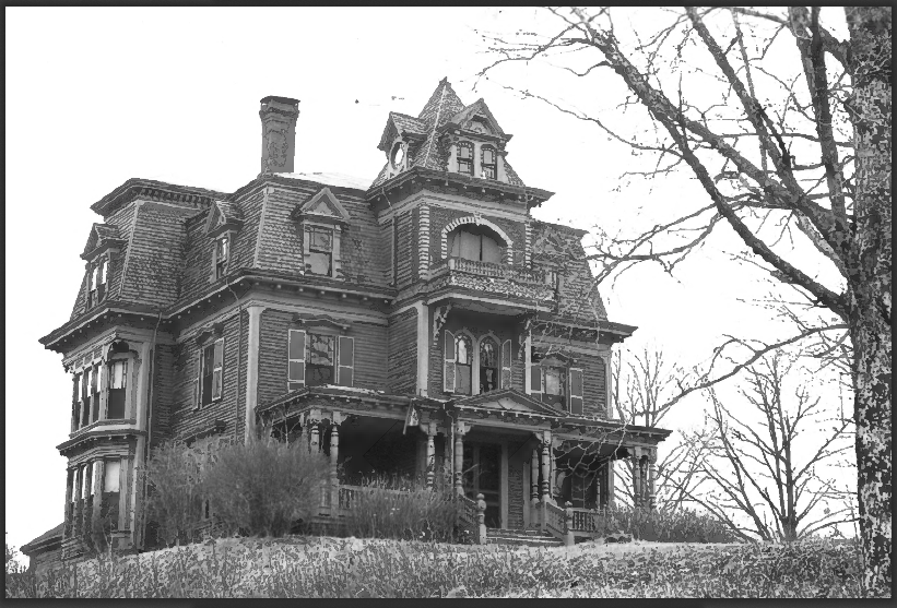
Colonel Samuel Campbell House
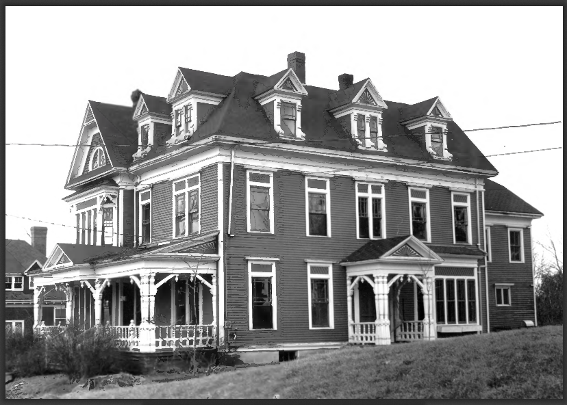
Samuel Campbell House (1981)
[U.S. Route 1] This impressively large and handsomely detailed Queen Anne house with both Stick and Eastlake elements is on a hill overlooking the town of Cherryfield. It was built in 1883 by Col. Samuel Campbell, a grandson of Gen. Alexander Campbell whose house of 1790 is immediately to the east.
Like his grandfather, he was well known in the lumber business in the Narraguagus Valley and active in local and state affairs. Between 1880 and 1882 he served on the Governor’s Executive Council. The Samuel Campbell House ranks among the finest of its period in eastern Maine.* [Frank A. Beard photo]
David W. Campbell House
")
David W. Campbell House (2004)
[Main Street] This remarkable house is significant because of the interesting melding of architectural styles and features applied to it over the years since its construction in 1828 as a Federal style home. The David Campbell House has ornamentation reflecting two or three mid-19th century stylistic periods. For whatever reasons, these alterations and additions produced a structure of great charm and individuality.
It is one of four houses to be nominated to the National Register in Cherryfield built by a member of the illustrious Campbell family all descended from Gen. Alexander Campbell. The others are the high style 1875 Mansard house of Frank Campbell and the imposing 1883 Queen Anne built by Col. Samuel Campbell.*
Frank Campbell House
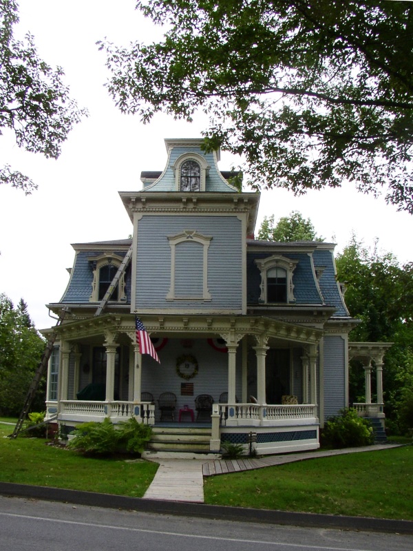
Frank Campbell House (2004)
[US Route 1] The Frank Campbell House is one of the most distinctive Victorian houses in Maine, unique in design and beautifully whimsical in spirit. Cherryfield’s Charles A. Allen, among the more imaginative small town Maine architects, gave a lighthearted and flamboyant interpretation to the usually staid and class-conscious Second Empire style.
Cherryfield’s architectural heritage is one of the richest in eastern Maine. Many wooden houses with unabashed use of ornamentation adorn small bluffs on both sides of the Narraguagus River. At least four and one church are the work of Charles Allen.
This house, along with the William Nash House, are among the most interesting in town, perhaps in eastern Maine. The broad, concave slope of the house’s tower is one of only two in the state. It is also notable for its excellent state of preservation, with only two minor changes having occurred since construction. The house sits on a hillside just above the town’s main crossroads, with ample acreage and a fine view of the Cherryfield vale.*
General Alexander Campbell House
")
Alexander Campbell House (1976)
[Campbell Hill] Apart from its architectural merit, the house has significance from its original owner, recognized as “the most distinguished man of his time in Eastern Maine.” Born in 1731 in Georgetown, Alexander Campbell was active in the military during the French and Indian War. In 1755 he served in Thomas Phillips Company of Rangers scouting “to the westward” and in 1757, in Captain Jabez Bradley’s Company at Fort St. George. He participated in the siege and capture of Quebec in 1759. Campbell and Captain William Nickels discovered two daughters of the Preble family there, who were abducted from Day’s Ferry by Indians in 1758 and sold to the French. They obtained the girls’ release.
Campbell moved to Newcastle where he was an innkeeper and ferryman, later moving to Steuben where he built a lumber mill on the Tunk River. He then moved his mill to the Narraguagus River in Cherryfield and built a house on Shipyard Point. By 1775 he had acquired over 200 acres of timberland in the Cherryfield region.
Campbell was active in military operations in Eastern Maine during the Revolution. In 1776 he raised a regiment of militia. In 1792 he was awarded 2000 acres in Whiting for his services. Following the war he continued his lumber business and, in 1790, built the house in Cherryfield. He was active in public service until his death in 1807.* [Earle G. Shettleworth, Jr. photo]
Cherryfield Academy
[Main Street] Although many academies were built throughout Maine in the mid-nineteenth century, Cherryfield Academy was an unusually ambitious structure. The large Greek Revival style institutional building, erected in 1850 in a fairly remote area of the State, is a well-preserved local landmark. The Academy was incorporated in 1829. For the first ten years classes were held in an old, restored meeting house; then, for ten years, the school languished. Finally, in 1850, the Union School District was formed to provide the Academy a permanent home. The first floor of the new building was used as a town hall and for public entertainments, the second for the school.
Between 1875 and 1895, Cherryfield Academy operated as a free high school, but in 1895 it returned to its former Academy status. Financial aid form the Legislature was given in hopes of advancing the interests of higher education as well as those of common schools. Until December of 1964, Cherryfield Academy conducted classes, but at that time a new regional high school was completed. The old Academy building once housed the town office, the Public Library, and a recreation center.*
In 2015 it was awarded $125,000 to improve the structure that serves as the Cherryfield Academy Community Center. (See photo above.)
Cherryfield Historic District
")
Arthur L. Stewart House in the District (2004)
[roughly bounded by Church, Main, Park, New and High Streets, as well as River Road properties] The Cherryfield Historic District is a collection of substantially intact residential and commercial buildings that clearly depict the 19th century development of this river community. Located on both sides of the Narraguagus River, Cherryfield flourished in its position as a lumber milling and shipping center. This prosperity is particularly evident in the existing houses, among which are a group of notable Second Empire style dwellings. The district is significant by virtue of its depiction of community development; its association with commerce; its association with significant people; and its architectural history.
The district is an area of approximately 75 acres on both sides of the Narraguagus River. It is bisected by the east-west path of U.S. Route 1 and framed by the north-south secondary roads 182 and 193 (Main Street). Although it is comprised principally of residential buildings, including 52 historic properties, such as the 1850 Arthur L. Stewart House and others noted here. The district does include the historic commercial district.*
William M. Nash House
William Nash House (1982)
[River Road] The Nash House is one of Maine’s finest and most distinctive late 19th century houses. As a picturesque interpretation of the Mansard and Queen Anne styles, it is probably unrivaled in the state. The house also has a fascinating architectural history, having been remodeled from a Cape Cod cottage to a Greek Revival “temple” house, then thoroughly redesigned in a High Victorian style. William M. Nash had the house remodeled in 1888 into its present configuration, from designs drawn by architect William A. Allen of Cherryfield. In addition to an extra Mansard story, Allen’s design added a tower, porch, and two pavilions. It is also one of the most compelling late-Victorian houses in the state. The tower is markedly human-like with its mouth-like balcony opening, the eye-like doubled arched windows and other features that resemble raised eyebrows.* [Frank A. Beard photo]
Patten Building
")
Patten Building (1978)
[Main Street] This store was built in 1865 by Frank W. Patten to be used “as a boot and shoe store and manufactory.” Over the years, this building has served as a meat market, pool hall, photography shop and barber shop. As a home for many varied businesses, it became important to the people of Cherryfield and became a local landmark. This structure is an example of a rural store built in the Italianate style, a rare style in such a relatively remote location. The building was given to the Cherryfield-Narraguagus Historical Society in the 1970s.* [Earle G. Shettleworth, Jr. photo]