
Location Map For Castine
| Year | Population |
|---|---|
| 1970 | 1,080 |
| 1980 | 1,304 |
| 1990 | 1,161 |
| 2000 | 1,343 |
| 2010 | 1,366 |
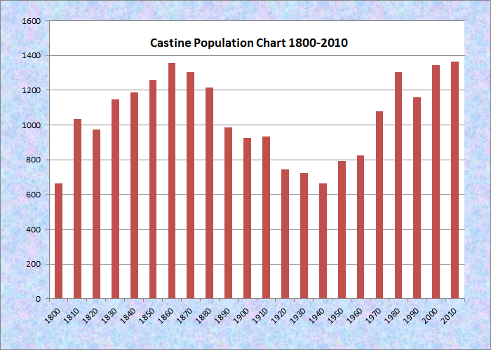
Population Trend 1800-2010
| Geographic Data | |
|---|---|
| N. Latitude | 44:24:32 |
| W. Longitude | 68:48:56 |
| Maine House | District 133 |
| Maine Senate | District 8 |
| Congress | District 2 |
| Area sq. mi. | (total) 20.0 |
| Area sq. mi. | (land) 7.8 |
| Population/sq.mi. | (land) 175.3 |
| County: Hancock
Total=land+water; Land=land only |
|
[kas-TEEN] a town in Hancock County, was once known as Majabigwaduce or Bagaduce for short, now the name of the river on its eastern shore.
In 1629 the (British) King’s Council for New England authorized Edward Ashley to establish a trading post at what was then Pentagoet, the eventual administrative capital of French Acadia.
By 1631 the post was destroyed by the French for the first time, then again in 1634. The post lasted until 1674 when a Dutch privateer destroyed it. The Massachusetts Bay colonists attempted to assert their claim, to no avail.
")
Castine Across the Bagaduce River from Brooksville (2008)
Incorporated in 1796 from portions of the town of Penobscot, it later set off land to Brooksville (in 1817) and then acquired some of the earlier land it had ceded to Penobscot.
The town is named for Jean-Vincent d’Abbadie, Baron de St. Castin who held a French land grant in the area. He made friends with the Indians, attempted to accommodate the English, then fought them and the Dutch to protect the area. The British finally took the town in 1779, but now the colonists wanted them out. That year Castine saw the defeat of American forces attempt, known as the Penobscot Expedition, to liberate the town. It returned to American control in 1783 at the end of the Revolutionary War.
")
Historic Site in Castine (2001)
George Varney waxed eloquent in his description of Castine in his 1886 Gazetteer of Maine:
The streets of the village are set with shade trees of all ages, and the buildings are in good repair. Many of the dwellings are large and old, and there is an air of elegance and repose. Before it spreads out the grand harbor, dotted with islands.
The second reported meteorite ever to hit Maine fell at about 4:15 AM on Saturday May 20, 1848 near the village in Castine.
")
Fort Madison in Castine (2001)
Two forts, Madison and George, are among the many historic sites throughout the community. Castine’s location on a neck of land at the mouth of the Penobscot River gave it substantial military importance, making the British occupation of the town during the War of 1812 very understandable.
Castine was the first shire town of Hancock County until 1838 when the county seat was moved inland to the City of Ellsworth.
")
")
Hancock County Register of Probate, Castine selectman, and U.S. Representative Hezekiah Williams lived and practiced law here in the 19th century. In 1880, Simmy Murch, was born in Castine; in 1904 and 1905 he played baseball for the St. Louis Cardinals. After a less than stellar career there, he played for the Brooklyn Superballs in 1910. In the three years his batting average was .141; as an infielder he made no outs.
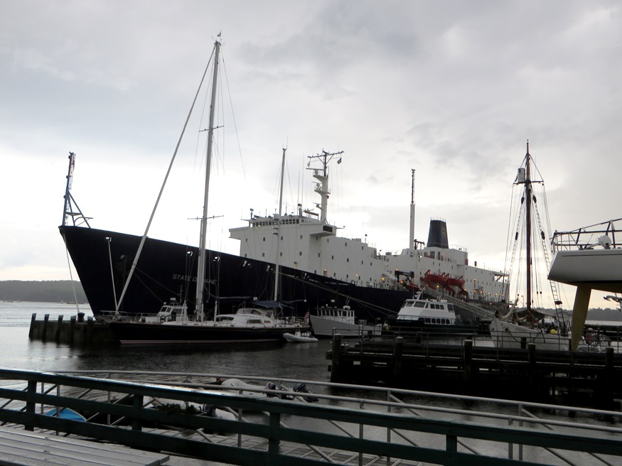
The Maine Maritime Academy, established in 1941, and its training ship State of Maine, are located in the town.
")
Houses near the Academy (2001)
")
View of Bagaduce River (2001)
Form of Government: Town Meeting-Select Board-Manager.
More Videos!
Additional resources
Broom, Dick. “Reclaiming Castine.” UMaine Today. March-April, 2006. http://www.magarchive.umaine.edu/issues/v6i2/castine.html (accessed October 16, 2011)
Castine Sesquicentennial Celebration: July 27, 1946. 1946 July 28. (Maine State Library)
Faulkner, Gretchen Fearon. Fort Pentagoet, Castine, Maine, 1635-1674: An Archaeological and Historical Perspective of the Anglo-Acadian Frontier. 1984.
Fort Pentagoet. (video) Maine Public Broadcasting: Home: The Story of Maine, Episode 302, “Rolling back the frontier” http://www.windowsonmaine.org/fullrecord.aspx?objectId=9-65 (accessed June 3, 2008)
Hathaway, Katharine Butler, 1890-1942. The Little Locksmith: A Memoir. Foreword by Alix Kates Shulman; afterword by Nancy Mairs. New York. Feminist Press at the City University of New York. 2000.
Honey, Mark E. Abigail & Sarah Hawes of Castine, Navigators & Educators. Lois Moore Cyr, editor. Honey. c1996.
*Maine. Historic Preservation Commission. Augusta, Me. Text and photos from National Register of Historic Places: http://pdfhost.focus.nps.gov/docs/nrhp/text/xxxxxxxx.PDF and http://pdfhost.focus.nps.gov/docs/nrhp/photos/xxxxxxxx.PDF
Cate House: 70000040.PDF
Castine Historic District: 73000240.PDF
Fort George: 69000007.PDF
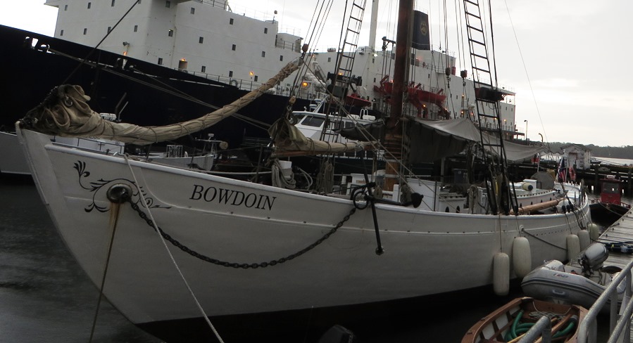
Schooner Bowdoin: 80000411.PDF
Sylvester, Herbert Milton. The Land of St. Castin. Boston. W. B. Clarke Co. 1909.
Wheeler, George Augustus. Castine, Past and Present: The Ancient Settlement of Pentagöet and the Modern Town. Boston. Rockwell and Churchill Press. 1896.
Wheeler, George Augustus. Fort Pentagoet, and the French Occupation of Castine. Portland, Me.? Maine Historical Society. 1892?
Williamson, Joseph, 1828-1902. Castine; and the Old Coins Found There. Portland, Me. Brown Thurston., 1859.
National Register of Historic Places – Listings
BOWDOIN (schooner), National Historic Landmark
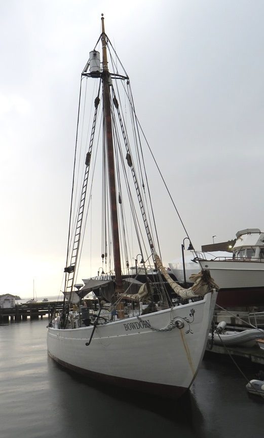
Schooner Bowdoin at Castine Waterfront (2014)
[Maine Maritime Academy] The 1921 88-foot schooner Bowdoin [see brief 1933 film at MacMillan article] was built to the specifications of Admiral Donald Baxter MacMillan, an important Arctic explorer among other pursuits. This sailing vessel was designed to operate with a small crew and with an auxiliary engine. MacMillan made 29 voyages to the Arctic between 1908 and 1954, 26 of which in Bowdoin. This two-masted schooner, built to his specifications (strong and compact) for Arctic exploration, is one of a handful of such historic vessels.
Schooner Bowdoin at Castine (2014)
The Bowdoin logged more than 200,000 miles, while the crew and scientists gathered information on the Arctic environment. During World War II, Bowdoin and MacMillan were commissioned by the U.S. Navy to serve on the important Greenland Patrol, assisting in the defense of that island. After years of neglect, the vessel was restored at the Maine Maritime Museum in Bath in the early 1980s. After a brief stint with Outward Bound, it was given to the Maine Maritime Academy.*
Castine Historic District
[Roughly bounded by Bagaduce and Penobscot Rivers, and Wadsworth Cove Road] The 1,800 acres of land and water in the Historic District includes a cross section of late 18th and 19th century architecture in Castine: early capes, several magnificent Federal Period houses, an abundance of Greek Revival architecture, several elaborate summer houses of the late 19th century, Maine Maritime Academy’s Leavitt Hall, and the historic Schooner Bowdoin.
")
Castine Harbor in the Historic District (2014)
")
Unitarian Church in the Historic District (2014)
Intermingled with these are many historic sites: a British Fort from the Revolution, the site of a French fortification of an earlier period, the site of the greatest naval defeat in American History and even the very visible remains of a canal dug by British troops in 1779, and the Dice (Dyce) Head lighthouse.*
Cate House
")
[Corner of Court and Pleasant Streets] The Cate House, or Adams House, was built in 1815 for Thomas and Jane Russell Adams. Their granddaughter, Mrs. Anna Dole, was raised here. In this house Anna married Sanford Dole, who became the first and only president of Hawaii in 1893. Later Dole became the first Governor of Hawaii. Dole was a relative of James Dole, the Hawaiian pineapple baron. Harriet Beecher Stowe spent several months at the house. Homes such as the Cate House were built when Castine was one of the wealthiest towns of its size in Maine.
Thomas Adams was born in Pembroke, New Hampshire in 1983. He married May 23, 1815, to Miss Jane Russell of St. Andrews, New Brunswick. He was a Representative to the General Court of Massachusetts as well as a selectman for Castine. Adams died in Roxbury, Massachusetts in 1847.
Jane Elizabeth Cate was the daughter of Thomas and Jane Russell Adams. After her marriage to Charles Cate she continued to live in her girlhood home, the fine old place at the corner of Court and Pleasant Streets. Mrs. Cate spent her remaining years in Castine raising not only her own family, but later her brother’s six children when they became too advanced for the schools in Honolulu.* [Maine Publicity Bureau photo]
Fort George
")
[Wadsworth Street off Battle Avenue] The exploring Cabots sailed near Castine for England in 1497. Since then, because it commanded the approach to the Penobscot River, its history has been colorful and complex with many adventurers and explorers. For the French, Jacques Cartier, Samuel Champlain, Sieur deMonts, Father Biard, and Mons. Vincent de St. Castine or Baron St. Castin, for whom the town was named. For the English, Captain George Weymouth, Captain John Smith, Isaac Allerton and Miles Standish of Plymouth Plantation. The Dutch were here twice; the Spanish, once.
") The first fortification in Castine, about 1626, was probably built by the French or the Pilgrims. Fort George was built by the British to protect their interests in the Bay of Fundy and Nova Scotia by sea, and prevent land action against lower Canada. On June 17, 1779 British General McLean and Captain Mowat of the Royal Navy arrived with 750 land forces and three sloops of war; work began on the fort. Since the fort cut off Boston merchants from one of their best sources of lumber, the Massachusetts General Court demanded action.
The first fortification in Castine, about 1626, was probably built by the French or the Pilgrims. Fort George was built by the British to protect their interests in the Bay of Fundy and Nova Scotia by sea, and prevent land action against lower Canada. On June 17, 1779 British General McLean and Captain Mowat of the Royal Navy arrived with 750 land forces and three sloops of war; work began on the fort. Since the fort cut off Boston merchants from one of their best sources of lumber, the Massachusetts General Court demanded action.
")
Fort George Plan (1815-1819)
On July 21st Commodore Saltonstall and General Lovell reached Castine. This was the largest amphibious expedition of the American Revolution, with 37 ships mounting 328 guns and 2000 men. Being too cautious, Saltonstall, with his 37 ships, refused to attack the 3 British ships. It was August 1lth before an all out attack was initiated and it was barely under way when 6 British sails were sighted. They headed for the center of the Massachusetts fleet and Commodore Saltonstall called the attacking land forces back on board and sailed up the Penobscot to complete annihilation. This virtually marked the end of the Continental Navy. Second in command of the land forces was General Peleg Wadsworth, grandfather of one of Maine’s best loved poets, Henry Wadsworth Longfellow. General Wadsworth was captured and imprisoned here but escaped by way of Wadsworth Cove. At the end of the American Revolution this was the last fortification that the British evacuated.*
Off-the-Neck Historic District
[Maine Route 166] The area included in this nomination represents a rural landscape that has changed little and includes eleven farmsteads dating between 1760 and 1820. The turbulent history of Castine is well known. Between the English and French and later the English and Americans, it was an important seaport until the end of the days of merchant sail.
")
James Scott House (Frank A. Beard photo, 1986)
The town is dramatically separated between the more heavily populated and commercial peninsula located between Penobscot Bay and the Bagaduce River, and the Off-The-Neck or mainland area connected to it by a narrow piece of land. The Off-The-Neck area, is separated from the village historically and economically as well as by geography.
")
Miles Gardner House (Frank A. Beard photo, 1986)
Settled in the 1760, it depended largely on an agrarian economy. It provided the produce required by the more heavily settled peninsula that was entirely maritime oriented with shipping, ship building and fishing. Also unlike the peninsula, this region was relatively unaffected by the political and military strife that typified the history of the village. Indeed, the “British Canal”, which marks the southern boundary of the district, was actually a defensive barrier built during the English occupation in the War of 1812. It is actually and symbolically the division between the mainland and the strategic port of Castine.
The houses in the Historic District are typical examples of Maine farmhouses during the Federal period (1790-1838). . The hilly terrain,with combinations of woodland and open fields bordering rocky inlets, are also characteristic of the region. What distinguishes the area is the very high concentration of relatively unaltered Federal and Greek Revival style farmhouses.

Hatcher-Keener House (Frank A. Beard photo, 1986]
Pentagoet Archeological District, Address Restricted
Perkins, John, House
[Perkins Street] The house is of more architectural than historic interest, being an excellent example of Colonial architecture. The cracks between the wall boards were covered by birch bark strips. The laths were of the split board variety and the timbers hand hewn. It was one of the first in the area, being built around 1765.
It survived the bombardment of 1779, and the British occupation then and later during the War of 1812. British officers were quartered in the house during the American Revolution as well as the War of 1812. Castine’s only pre-Revolutionary dwelling, it is worthy of a serious preservation effort. It is the only one that has so many fine details of late 18th century architecture. it is well worth saving. Historically and architecturally the Perkins House is outstanding and valuable; it is also intact and worth saving. [From the National Register Nomination in 1969]
THE JOHN PERKINS HOUSE was built about 1763 as a one-story house on what is now Court Street, but was then a wilderness. John and his young bride Phebe (sic), both from York, Maine, began their married life here. They had few near neighbors; by 1774 there were only six other houses on the Castine peninsula – three of these log cabins. As the Perkins family grew and prospered a four-room two-story addition was built across the gable end of the early home. Again, probably in 1783, the house was enlarged – the first one-story home being torn down to be rebuilt as a two-story ell.

John Perkins House in 1968, before restoration.
By the 1960s, through long neglect, the Perkins House was in very poor condition and had been condemned as a fire hazard. In December 1968, the Castine Scientific Society bought the house on Court Street and had it taken down piece by piece, beams, clapboards, moldings, bricks, timbers, etc. Next spring a cellar was dug on the grounds of the Wilson Museum, a concrete foundation poured and work on rebuilding the house began, all under the direction of Hoyt T. Hutchins. Much of the ell was too rotten to save but, fortunately, the kitchen could be. This and the four front rooms now appear as they did in 1783. The house on Court Street faced south, now it faces west, out the harbor. From Castine’s Wilson Museum.