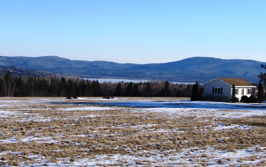
Panoramic view of Saponac Pond, fields and mountains in Burlington Village (2014)

Location Map For Burlington
| Year | Population |
|---|---|
| 1970 | 266 |
| 1980 | 322 |
| 1990 | 360 |
| 2000 | 351 |
| 2010 | 363 |
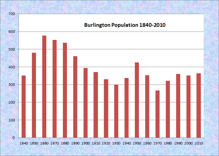
Population Trend 1840-2010
| Geographic Data | |
|---|---|
| N. Latitude | 45:16:08 |
| W. Longitude | 68:22:20 |
| Maine House | District 141 |
| Maine Senate | District 8 |
| Congress | District 2 |
| Area sq. mi. | (total) 56.2 |
| Area sq. mi. | (land) 53.8 |
| Population/sq.mi. | (land) 6.8 |
County: Penobscot
Total=land+water; Land=land only |
|
 N45° 12' 22.54\" W68° 26' 9.86\"") [BUR-ling-tun] is a town in northern Penobscot County just north of the Passadumkeag River. It was incorporated on March 8, 1832 from the unorganized township of T2 R1 NBPP, EPR. Named for a Massachusetts town, it annexed “two-mile strip” in 1835 and some additional land from Lowell in 1847. [click to enlarge an image]
[BUR-ling-tun] is a town in northern Penobscot County just north of the Passadumkeag River. It was incorporated on March 8, 1832 from the unorganized township of T2 R1 NBPP, EPR. Named for a Massachusetts town, it annexed “two-mile strip” in 1835 and some additional land from Lowell in 1847. [click to enlarge an image]
 N45° 12' 22.59\" W68° 26' 9.88\"")
Route 188 in Burlington near the Lowell Town Line (2014) @
 N45° 12' 27.07\" W68° 26' 4.14\"")
Burlington Lowell Transfer Recycling Station (2014)@
The township was first settled in 1824, probably by Tristam Hurd who donated the name “Hurd Ridge” to the area.
Burlington Village, in the western portion of the township, centers on Route 188 (which includes Church Hill Road and Main Road), Long Ridge Road, and Back Road, with connecting Hurd Road.
The old church is on Church Hill Road; the historic Tavern, on Main Road.
 N45° 12' 32.28\" W68° 25' 30.45\"")
“Ye Olde Tavern” (2014) @
 N45° 12' 31.15\" W68° 25' 31.38\"")
Burlington Bible Church (’14) @
In 1886, according to George Varney, “Much of the town is still covered with forest, consisting principally of maple, birch, beech, pine and spruce.”
“Burlington is on the stage line from Enfield, on the European and North American Railway. The extension of the St. Croix and Penobscot Railroad is expected to pass through the town. The church edifice is used by the different societies in common.”
Varney usually listed the “manufactures” of each town. They are conspicuously absent from Burlington in this period. Lumbering and agriculture have been the main occupations, supplemented by the staff of the Old Tavern.
 N45° 12' 32.41\" W68° 25' 29.04\"")
sign: “Burlington 4 H The Power of Youth!” (2014) @
 N45° 12' 32.41\" W68° 25' 28.77\"")
Burlington 4-H Agricultural Barn (2014) @
 N45° 12' 32.42\" W68° 25' 28.79\"")
Probable former Schoolhouse (2014) @
The village, where the photos above were taken, is about 45 miles north of Bangor, and east of the Howland exit on Interstate 95 following Route 188 east from Enfield.
Saponac Lake, in the south end of the town and at the north end of Grand Falls Township, is from the Indian word for “the big opening.” Originally called Chibanook, the lake has a wide opening before entering the Passadumkeag River. The lake (below) is visible in views from Long Ridge Road in the village.
 N45° 13' 17.94\" W68° 25' 11.72\"")
Old Barn on the Ridge (’14) @
 N45° 13' 8.69\" W68° 25' 13.57\"")
Saponac Pond (2014) @
 N45° 13' 8.97\" W68° 25' 13.97\"")
Farm Tractor (2014) @
 N45° 12' 45.73\" W68° 25' 28.02\"")
Burlington Town Office (2014) @
 N45° 12' 46.55\" W68° 25' 30.82\"")
Fire Department near the Town Office (2014) @
 N45° 12' 28.77\" W68° 25' 30.30\"")
“Harry S. Shorey Memorial Building” (2014) @
 N45° 12' 28.55\" W68° 25' 30.69\"")
Large House in the Village (2014) @
 near Mt. Repose Cemetery (2014) N45° 11' 32.16\" W68° 25' 9.33\"")
Mobile home village, Main Rd. near Mt. Repose Cemetery @
According to a history of the town “The most of these men had families, they were sturdy, vigorous, and industrious men; some of them had great natural abilities. Several were sons of Revolutionary soldiers, some served in the War of 1812; one served in the Mexican War and a large number in the Aroostook War.”
“When they came, it was to settle a veritable wilderness as their forefathers had done two hundred years before. Many came from comfortable homes and were highly respected members of their communities. Yes, it took a special breed of settle an unbroken wilderness — a special breed of men and women.” *
Form of Government: Town Meeting-Select Board.
Additional resources
* Hawkins, Alan H. History of Burlington, Maine Along the Passadumkeag. From Settlement to 1975. The Kennebec Journal, Augusta, Maine. 1977
Chadbourne, Ava Harriet. Maine Place Names and The Peopling of its Towns.
Eckstorm, Fannie Hardy. Indian Place Names of the Penobscot Valley and the Maine Coast.
Hawkins, Alan H. History of the Town of Burlington, Penobscot County, Maine from Settlement to 1975. Augusta, Me. The Kennebec Journal. 1977.
*Maine. Historic Preservation Commission. Augusta, Me. Text from National Register of Historic Places: http://pdfhost.focus.nps.gov/docs/nrhp/text/86000674.PDF.
Varney, George J. A Gazetteer of the State of Maine. 1886. p. 148.
National Register of Historic Places – Listings
Old Tavern
[Maine Route 188 and Old Dam Road] The Old Tavern is a well preserved early inn and tavern catering to lumbermen and drivers during the height of the lumber industry. Now a quiet community, Burlington was once a bustling, rough town on the Passadumkeag River. The building was filled with hard living, heavy drinking men during the log drive season. It was built by Amzi Libby who came from Limerick to Burlington about 1834. When he acquired the lot at “the corner” in 1844, he built the tavern, which served as a hotel for lumbering crews driving down the Passadumkeag or who were working in the Nicatous area, south east of Burlington in townships T3 ND and T40 MD, where Nicatous Lake is located.
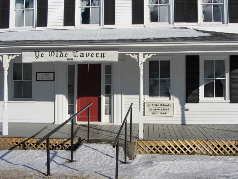
“Ye Olde Tavern” (2014)
Jeremiah Page bought the tavern in 1864. He became a prominent citizen as a merchant and innkeeper, also serving as selectman, town clerk and Justice of the Peace. Later the tavern became a popular headquarters for hunters and fishermen in the area.*
The local historical society purchased it in 1984. See photo above and interior photos at Ye Olde Tavern.
My family went there in 1976 to see my Great Grandparents, Norris and Elvie Moore. They had owned the tavern for many years. I remember riding with my Grandpa Norris on his tractor.