Beddington Lake from Route 193 in Beddington (2013)

Location Map for Beddington
| Year | Population |
|---|---|
| 1970 | 32 |
| 1980 | 36 |
| 1990 | 43 |
| 2000 | 29 |
| 2010 | 50 |
| Geographic Data | |
|---|---|
| N. Latitude | 44:49:02 |
| W. Longitude | 68:00:39 |
| Maine House | District 137 |
| Maine Senate | District 6 |
| Congress | District 2 |
| Area sq. mi. | (total) 38.3 |
| Area sq. mi. | (land) 34.0 |
| Population/sq.mi. | (land) 1.4 |
County: Washington
Total=land+water; Land=land only |
|
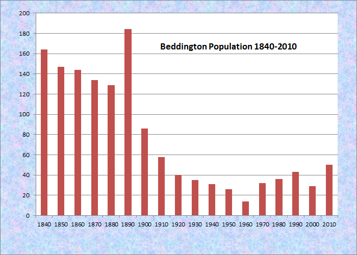
Population Trend 1840-2010

Town Line Sign Entering Beddington
[BED-ing-tun] is a town in Washington County, incorporated on January 31, 1833 from Plantation Number 23 MD. Beddington village is in the northwest corner of the town, “Upper Beddington,” on Route 9, which briefly runs through that area. Route 193 travels north-south in most of the western section, known as “Lower Beddington.”
Part of the Bingham Purchase, it was named after a borough near London, England. There was no known Native American settlement when the earliest Europeans arrived from Jonesboro in the early 1800s. The town’s population peaked in the mid-1800s. In 2006 there were 45 year round residents and 300 seasonal residents in cottages at the town’s lakes.
 N44° 47' 58.33\" W68° 2' 41.64\"")
Fire Dept/Town Office (2013) @
 N44° 50' 32.84\" W68° 4' 19.53\"")
Forest Ranger Station (2013) @
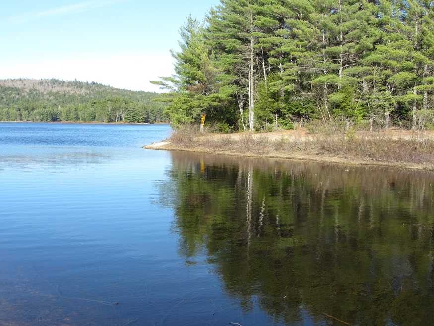
Fully 10 percent of the area is water, primarily in the form of Beddington Lake, Pleasant River Lake, Spruce Mountain Lake, and Big Bog Flowage.
The lakes are accessible primarily from secondary roads leading south from Route 9. Beddington Lake hosts the Narraguagus River, which passes through it and Deblois, Cherryfield, Steuben and ultimately empties into Narraguagus Bay at Milbridge.
 N44° 49' 4.36\" W68° 3' 22.69\"")
Beddington Lake (2013) @
")
Beddington Lake (2013)
The oldest houses are the Schoppee House, on Shoppee Hill, and the Bridgham house, both built in 1830. The Bridgham House was owned by Leverett Clifton Bridgham, born in Machias in 1842.
He enlisted August 1862 in the 1st Maine Heavy Artillery, Company H. His regiment suffered the greatest loss of any in the Union.
 N44° 50' 53.28\" W68° 3' 41.84\"")
The Bridgham House (2013) @
 N44° 50' 53.54\" W68° 3' 42.77\"")
Schoppee House Cabins (’13)@
 N44° 50' 53.36\" W68° 3' 41.96\"")
The Schoppee House (2013)@
Beddington was a stage coach link on the Airline Stage Route (now state Route 9) during the late nineteenth century. The Old Shoppe House was once a stagecoach stop for the Bangor-Calais route, and for another that came from Cherryfield.
According to Maine: A Guide Downeast, in 1858 the future President of the Confederate State of America, Jefferson Davis, stayed at the Old Shoppe House while visiting Alexander Bache. Davis was a U.S. Senator and Bache was with the U.S. Coast Survey Service running a base line between Deblois and Columbia. Supposedly, Davis left a small chest with Bache to deliver to a man who would come for it and give a certain sign. The delivery, of what might have been documents related to the upcoming Civil War, was made in the fall of 1858. [See Harold Nelson’s contribution below.]
In the 19th century, several sawmills were in business, one on Church Farm Road and several others along the Narraguagus River. A local lumber baron operated a sawmill near Church Farm during the 1950s. Lumber was floated down the Narraguagus River to the boat building and shipping operations in Cherryfield. A tannery was located at the foot of Schoppee Hill during the 1880s .
The first school, the North Beddington School, was on Schoppee Hill; another was on Route 193. In 1840 the two educated 40 students.
Blueberries have been a staple crop for much of the town’s history. During the Civil War, berries were hand-picked and hand-canned for delivery to the Union Army. Berries were also packed for shipment by schooner in one quart wooden casks for the the 2 1/2 day sail to Boston. Later, they were taken to the railroad in Cherryfield for trip to Boston. The most significant agricultural activity in Beddington is blueberry production, with about 1000 acres in this industry.
 N44° 50' 51.84\" W68° 3' 44.39\"")
Wind Turbines from Beddington (2013)
The vast majority of the land in town is in industrial forestland ownership. In the mid- to late-1800s most of the arable land was in pasture and fields.
An indicator of more recent land use is seen in this view of wind turbines, southwest from Shoppee Hill on Route 9. These are on Bull Hill in T16 MD township in Hancock County, about ten miles from Beddington.
Blueberry and forestry industries provide income for many residents. Other sources include agriculture, construction, health care, industry, crafts, natural resource management, outdoor recreation, pensioners, and wreath making.
Form of Government: Town Meeting-Select Board.
Additional resources
Bache had stayed at station HUMPBACK 1858 on now Lead Mountain, but Davis, his wife Varina and their two children who were on the trip also, had to return home. It is no doubt that the chest left at the Shoppe House were triangulation and scientific notes of Bache, which would have been sent to Washington. Actually, there were always 2 copies of field notes made, travelling by different means to Washington, in case something happened to the original note. The second set were hand copied from the originals.
Davis probably did more in favor of the North, in that when Senator Benton wanted to put his son-in-law, John C. Fremont, in charge of the Coast Survey (removing Bache), Davis made a 7 page speech to Congress arguing in favor of Bache and his principles. When the vote came, Benton’s proposal only received 2 votes. Much detail can be read of this in the book Jefferson Davis-Ex-President of the Confederate States of America. Also, the Epping Baseline had already been measured by Bache in 1857, so Bache was making triangulation (horizontal angles) measures to signal lamps from his associates on other hilltops. I am the Senior Geodesist for the Maine Department of Transportation and have researched this history quite a bit. Thanks for including this in your website, there should be a plaque at the scenic turnout on the Whalesback.
Thank you Mr. Nelson for a fine addition!