")
Eastern Shore of Bailey Island near the Giant Steps (2017)

Location of Harpswell, including Bailey Island.
")
Cottage on Bailey Island (2009)
")
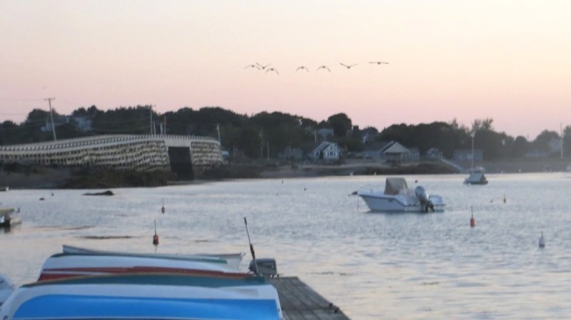
Casco Bay from Bailey Island (2007)
")
Rocky Shore of Bailey Island near the “Giant Stairs” (2002)
")
1885 Baileys Island Union Church (2015)
")
Bailey Island, Me. Dept. Marine Resources (1992)
[BAY-lee iland]
The island is in the town of Harpswell on Casco Bay.
For over two centuries of European settlement, Bailey Island was unconnected from the mainland. Though proposed as early as 1872, a bridge was not built until the twentieth century. The historic bridge, possibly unique in its construction, but showing signs of age, was faithfully reconstructed and reopened in 2010.
Since 1926 Bailey has been connected to Orrs Island by the locally known “Cribstone Bridge,” built of granite supports with openings allowing the strong tides to pass through Will’s Gut. “Will” was the son of the original settler, Will Black, who arrived in the early 18th century. The younger Will filed a claim for the island in about 1730 and received title to what was then known as Will’s Island.

WW II Submarine spotting towers on Bailey Island

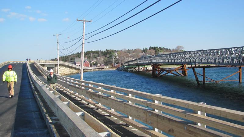
Cribstone Bridge between Orr’s and Bailey Islands
But, in 1750 Hanna Curtis, wife of Deacon Timothy Bailey, bought the island from “the North Yarmouth Land Proprietors for one pound of tobacco and one gallon of rum,” according to Dorothy Simpson. This resulted in voiding Will Black’s title, forcing his family to move to nearby Orr’s Island.
")
Sculpture to “All Maine Fishermen” (2013)
Mackerel Cove, a major fishing harbor, is located at the southern end of the island. In the video below, note the mixture of working and pleasure boats, a sight more common in southwestern Maine than Downeast. In the still picture at the end, the floats have lobster traps piled on them.
Underneath the floats, actually “lobster cars,” lobsters are penned in the water to keep them alive and fresh until delivery to market.
The image of Bailey Island in the upper right is a composite of three images taken from the Maine Department of Marine Resources, Coastal Photo Holdings.
During World War II towers were erected on Bailey and other Casco Bay islands to serve as lookout points watching the coast for submarines, suspicious boats or other activity. These watchtowers are now inactive and off limits to the public.
In modern times, Bailey Island has become very densely populated with little, if any, room for additional building. Water is a major limitation, with problems of salt intrusion into wells. The Island hosts several restaurants and lodging establishments.
A replica of Victor B. Kahill’s sculpture, popularly known as “The Maine Lobsterman,” exhibited at the 1939 Worlds Fair, sits at the south end of the island with a view of Casco Bay and its islands.

Cottage on Casco Bay (2009)

Roses near the Giant Stairs (2009)
See the other Harpswell villages: Eagle Island, Haskell Island, Orrs Island, Harpswell Center, West and South Harpswell, North Harpswell and Cundys Harbor.
More Videos!


Additional resources
Babicki, Mo. Island fisherman: A Lobster Village Story. illustrated by Glenn Chadbourne. Bailey Island, Me. Lobster Legacies. c1999.
Hill, Beth E. The Evolution of Bailey’s Island. B. E. Hill. c1992.
Jensen, Nancy Orr Johnson. Bailey Island: Memories, Pictures & Lore. Mahomet, IL. Mayhaven Publishing. c2003.
Maine Department of Marine Resources. Coastal Photo Holdings (1992). A5085-24-1, A5085-24-3, A5085-24-4, at http://www.maine.gov/dmr/aerialphotos/preview/zone2/zone2.html (accessed 2/18/08)
Simpson, Dorothy. The Maine Islands in Story and Legend. pp. 86-87.
Wescott, Richard. A History of Harpswell, Maine. Brunswick, ME. Blackberry Books. 2010.
National Register of Historic Places – Listings
Bailey Island Cobwork Bridge
[On Maine Route 24 connecting Bailey and Orrs Islands, locally known as the “Cribstone Bridge.”] (See photo of the old bridge above.)
The Cobwork (Cribstone) Bridge, completed in 1928, spans the 1,200 foot Will’s Gut between Bailey and Orr’s Island in Casco Bay. On a natural reef granite blocks were laid in open construction, first lengthwise, then crosswise in a crib style manner. No mortar or cement was used. Due to the uneven shapes of the rough cut stones, pine wedges were driven in the cracks between them at certain places to prevent rocking and shifting.
At the center, over the deep channel, a single steel span of 52 feet rested on solid concrete pillars, lined with granite stonework and the roadway across the bridge was of reinforced concrete. The famous bridge connecting Orr’s and Bailey Islands represents a unique solution to a difficult engineering problem and is the only one of its kind in the United States. The swift the tides in Will’s Gut, which it spans and the consequent battering of floating ice created unusual challenges in design. The granite slabs quarried in Yarmouth are heavy enough to withstand the buffeting of waves and ice. The open construction permits the tidal currents to flow freely.
Geese over New Bridge (2012) [click to enlarge]
Cribstone Bridge on Reopening Day (2010)
In the early 21st century, problems with the movement of the supporting granite required attention. While a modern bridge was proposed to replace it, Harpswell residents strongly supported the historic design. The Maine Department of Transportation dismantled the old bridge, renovated its foundation, and applied a new, slightly w1der travel surface and sidewalk. The multi-year project, including a temporary bridge, was completed on November 20, 2010. (New bridge is on the right in the photo above left; the temporary bridge is at right in that photo.)
Bailey Island Library Hall
 N43° 43' 57.32\" W69° 59' 43.45\"")
Library Hall (2014) @
[2167 Harpswell Island Road] Library Hall is the most noteworthy and visible 20th century architectural landmark on the island. Located on the main road through the village, the building was erected in 1912 by the Bailey Island Library Association, a mixture of year round and summer residents, to serve as a social hall and lending library. The wood framed structure was designed by the New York architectural firm of Mann & MacNeille, both summer residents on the island. In design it strongly references George Washington’s Mount Vernon, complete with cupola, colonnade and Palladian windows. Although the library no longer functions, the building continues as a community hall for the island.
Originally known by the Abenaki Indian name Newaggin (“swift current place”), the island was settled by William Black by 1727. In 1742 it was sold to Timothy Bailey, for whom the island was then named. From the 18th century to the present the island economy revolved around the fishing (now lobstering). Until the Bailey Island Cobwork Bridge was built to Orrs Island in 1928, connection with the rest of the town relied on water transportation. Most of the residences and businesses are strung along the Harpswell Islands Road (Route 24).
Halfway Rock Light Station
[Casco Bay off Bailey Island] Halfway Light Station lighthouse marks the half-way point between Cape Elizabeth and Cape Small in Casco Bay.