Old Orchard Beach

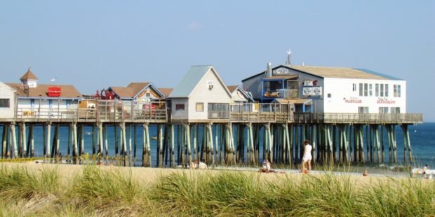
See photos. Richard Boynthon settled the area in 1631 and hosted meetings of the councilors governing Sir Fernando Gorges‘ Province of Maine in the early 17th Century. Thomas Roger planted an apple orchard in 1638 that became known as “Rogers’ Garden by the Sea” by 1657. The Boston to Portland railroad passed within two miles of town in 1842 and the Grand Trunk Railroad connected Old Orchard Beach to Montreal in 1853, encouraging Canadians to visit the beach. By 1873 the Boston & Maine Railroad passed through the town, now served by Amtrak.

Old Town

The town is heavily influenced by the nearby University of Maine, and the long-lived Old Town Canoe Company maintains an outlet that attracts customers with a broad range of outdoor recreation interests. See photos. DeWitt Field, Old Town’s municipal airport, hash three runways. Since 1669, the area has been the principal home of the Penobscot Indians.

Oliver, James

James Oliver (1895-1986) a U.S. Representative was born in South Portland on August 6, 1895. He attended the public schools, and earned an A.B. from Bowdoin College in 1917. During the First World War, Oliver enlisted on June 4, 1917, attended the Plattsburg Barracks Training Camp, and was commissioned a captain on November 27, 1917.…

Orient

The name derives from its eastern location adjoining New Brunswick. Its eastern point lunges into Grand Lake and North Lake on the Canadian border, accessible by the Boundary Road. Sunset Park and other camping areas are attractive vacation locations. U.S. Route 1 runs north-south through the middle of the township. Orient village is just east of Route 1 on the Boundary Road.

Orland

Small pond with a fishway and an outlet to Toddy Pond, surrounded by U.S. Route 1, Toddy Dam Road, and Hatchery Road in East Orland (2010)

In addition to Alamoosook Lake, the town hosts Craig, Heart and Toddy ponds, and the State’s Craig Brook Fish Hatchery. See video and photos. Located just east of Bucksport, Orland is a growing community, whose old village center is located on the Orland River, where the old village school and the general store are located. H.O.M.E., a crafters’ cooperative was established by Sister Lucy Poulin in 1970.

Orneville Township

Route 155 in Orneville between Bradford and Lagrange. (2014)

Orneville, east of Lagrange, is heavily forested. It has one small village, Boyd Lake, on Route 6/16 near Boyd Lake itself. Maine combined Routes 6/16 in the east and Route 11 in the west and a short stretch of Route 155 between Bradford and Lagrange in the southeast are the major improved roads on the…

Orrington

1807 Orrington Cattle Pound (2003)

The town, on the east bank of the Penobscot River, is a suburb of the Bangor-Brewer area, showing moderate but consistent growth in recent decades. As part of the agricultural tradition throughout Maine is the usually circular, rock walled cattle pound, often used as a site to buy and sell farm animals, and to hold wandering livestock to keep them from destroying crops.

Osborn Plantation

Panoramic View of Mountains looking West from Route 179 in Osborn (2013)

Osborn hosts two lots of Maine’s Public Reserved Lands with many trees well over 100 years old. The Osborn lots have a long history of timber management. Spectacle Pond, through which the Union River flows, is a major asset of the town. With few major roads, it is served in its northwest corner by Maine Route 179.

Otis

Boat Launch on Beech Hill Pond (2013)

Located just north of Ellsworth, the town is dominated by Floods Pond and Beech Hill Pond, with several smaller ponds and streams mixed in. See photos. The small, old cemetery and the working forest symbolize Otis’ past and present as a sparsely populated, wooded area off the major highways.

Otis, John

John Otis (1801-1856) a U.S. Representative, was born in Leeds on August 3, 1801. He attended the common schools and was graduated from Bowdoin College in 1823. Otis studied law, was admitted to the bar and began his practice in Hallowell in 1826. A member of the Maine House of Representatives in 1841, he was…

Otisfield

Bridge Over the Crooked River from Otisfield to Harrison (2012)

Just north of the town of Casco on Maine Route 121, it offers substantial frontage on Pleasant and Thompson Lakes. The Crooked River serves as its boundary with Harrison. The Bell Hill Meetinghouse and Bell Hill Schoolhouse are well-preserved National Register historic structures in a rural setting.

Owls Head

The Knox County Regional Airport is located in Owls Head and is one of Maine’s busiest during the summer months. Owls Head State Park offers views of Penobscot Bay and the nearby Owls Head Transportation Museum contains vintage aircraft frequently flown over the Bay. Owls Head Light Station marks the southern entrance to Rockland Harbor.

Oxbow

Panoramic View North from Oxbow Road (2008)

Virtually all of the plantation’s population is located along the Oxbow Road, leading West from Maine Route 11. See photos. Aroostook River through the area make shapes similar to oxbows, the harness that keeps oxen attached to their loads. The western end of the Oxbow Road is marked by the “Oxbow Checkpoint,” an entry point to the North Maine Woods, most of which is privately owned.

Oxford

Field Overlooking Thompson Lake in Oxford (2012)

Routes 26 (the commercial strip) and 121 serve the community. See photos. The Oxford Casino is on Route 26 in the south of town. Oxford village, at the north end of Thompson Lake, hosts the town office, post office, and a small veterans memorial park. The Congregational Church was established in 1806 and is listed on the National Register. Though famous for auto racing at Oxford Plains Speedway, the nearby Androscoggin River passes several sizable ponds and Thompson Lake abuts the main village.

Oxford County

Map of Maine Counties and Baxter Park

Oxford County is the seventh largest in population of the sixteen counties, located in western Maine along the New Hampshire border to the east and the Province of Quebec border to the north. The northern parts of York and Cumberland counties were separated to form Oxford County on March 5, 1805.  As with many counties,…

Palermo

Boat Launch at Sheepscot Pond in Palermo (2016)

The town has three villages. Palermo, at the south end of Branch Pond, spills over into China and was once known as Branch Mills. Greely Corner is on Route 3 just west of Sheepscot Pond. East Palermo is on the same highway just east of Sheepscot Pond. Palermo is dotted with numerous ponds and streams, providing an attractive escape from business life in the Augusta and Belfast areas.

Palmyra

Location Map for Palmyra

The Sebasticook River passes through Douglas Pond at the south end of the town, just above Pittsfield. A golf course and campground is adjacent to White Pond, in the eastern portion of the town, where a “hand-carry” boat launch is available. The Madawaska Wildlife Management Area straddles Madawaska Brook and encompasses the Madawaska Marsh.

Paris

1856 Paris Hill Academy Building (2019)

The Paris Hill neighborhood has several architecturally interesting old homes, while South Paris has been the industrial and manufacturing center. See photos. On the Stearns Hill Road the old Hungry Hollow schoolhouse sits on a small plot. South Paris village, split by the Little Androscoggin River, is the main population center and is half of the Norway-South Paris community.