Penobscot County

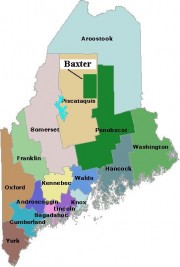
Map of Maine Counties and Baxter Park

is the thirdlargest in population of the sixteen counties, located in east central Maine, bisected by the Penobscot River and, the newer avenue of transportation, Interstate 95. Formed on April 1, 1816 from the northern part of what was then Hancock County, it later gave up territory to form Piscataquis and Aroostook counties. As with…

Oxford County

Map of Maine Counties and Baxter Park

Oxford County is the seventh largest in population of the sixteen counties, located in western Maine along the New Hampshire border to the east and the Province of Quebec border to the north. The northern parts of York and Cumberland counties were separated to form Oxford County on March 5, 1805.  As with many counties,…

Lincoln County

Map of Maine Counties and Baxter Park

is the thirteenth largest in population of the sixteen counties, located in mid-coast Maine. Its early history is well described as follows: Lincoln County was the most easterly of the two counties established, June 21, 1760, when York County was first divided. Its western boundary started at the eastern extremity of Casco Bay to New…

Knox County

Map of Maine Counties and Baxter Park

is the tenth largest in population of the sixteen counties, located in mid-coast Maine and home to about twenty moderate-sized islands, the largest of which are Vinalhaven, North Haven, and Isle Au Haut. It was formed on April 1, 1860 from parts of Lincoln and Waldo counties. The county currently consists of the city of…

Kennebec County

Map of Maine Counties and Baxter Park

is the fourth largest in population of the sixteen counties, located in central Maine and bisected by the Kennebec River. It was formed on February 20, 1799 from the northern part of Lincoln County.  It lost a large part of its original northern portion when Somerset County was created on June 1, 1809. At least…