T3 R10 WELS

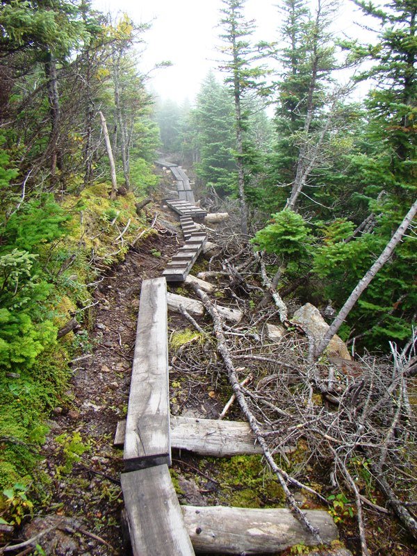
      APPALACHIAN TRAIL – ABOL BRIDGE TO DAICEY POND Abol Bridge is located on the Golden Road over the West Branch of the Penobscot River in township T2 R10 WELS. A private campground and general store sits just outside the boundaries of Baxter State Park and is a major destination for those hiking to…

T2 R10 WELS

Nesowadnehunk Falls on the Penobscot West Branch (2018)

Nesowadnehunk Falls on the Penobscot West Branch (2018)     Three Routes This township, officially known as T2 R10 WELS, is the crossroad of two major “highways” in Maine: The Golden Road and the Appalachian Trail. Both travel the Abol Bridge over the West Branch of the Penobscot River. The Golden Road From east of…

T1 R11 WELS

Detail of 1952 Jo-Mary Mountain, Quadrangle Topographic Map

The township is completely within a tract of Maine Public Reserve Land and lies immediately south of Rainbow Township, host to the next northerly section of the Appalachian Trail. Traveling south, hikers encounter Nesuntabunt Mountain and Nahmakanta Lake that reaches back into Rainbow Township. According to a 1960 survey, Nahmakanta (Abenaki for “plenty of fish”)…

Gulf Hagas

Long view of Gulf Hagas with Forested Cliffs

Gulf Hagas and The Hermitage are both located in the Bowdoin College Grant East, T7 R10 NWP, an unorganized township east of Greenville and northwest of Brownville. The area is part of the Appalachian Trail corridor owned by the National Park Service. Approaches from each town are over a private logging road on which control…

Elliottsville Township

Little Wilson Stream

Incorporated as a town, February 19, 1835,its incorporation was repealed May 26, 1858. Later reorganized as a plantation, January 3, 1887, it was deorganized March 31, 1983. Elliottsville is home to more than a dozen small ponds and the three-mile long Lake Onawa. The lake and southern portion of the township is accessible on the…

Pierce Pond Township

An Appalachian Trail Hiker Savors the Colorful Fall View

             An Appalachian Trail Hiker Savors the Colorful Fall View [PEERCE POND] a township in Somerset County, is home to all but a small portion of Pierce Pond, all of Upper Pierce Pond, Grass Pond and half of Kilgore Pond, which it shares with Bowtown Township to the east. Pierce…

Wyman Township

The Horns Pond on Bigelow Mountain (2003)

The Bigelow Public Reserve Land tract is located in Wyman Township, Bigelow Township, and Dead River Township in Franklin and Somerset counties. All three townships are contiguous and lie just south of Flagstaff Lake. East of Stratton in the town of Eustis, about 40 miles north of Farmington, it holds over 36,000 acres of public…

Sandy River Plantation

Mountain Ranges from the Saddleback Mountain Trail on the AT (2004)

About 35 miles northwest of Farmington on Maine Route 4, just south of Rangeley, the community marks the source of the Sandy River in the Sandy River Ponds. See map, video and photos. Four Ponds Public Reserve Land lies just east of Mooselookmeguntic Lake. Access is by the Appalachian Trail off Route 4 in Sandy River.

Township E

Sandy River at Smalls Falls and Roadside Picnic Area on Route 4 (2017)

 Sandy River at Smalls Falls and Roadside Picnic Area on Route 4 (2007) Township E is south of Sandy River Plantation, host to the next northerly section of the AT after Township D. (E Township is a different township in Aroostook County.) Township E, almost triangular in shape,  extends eight miles from Long Pond in…

Riley TWP

Boardwalks on the Goose Eye Trail (AT) in Riley Township (2007)

a township in Oxford County, just north of the town of Gilead on the border with New Hampshire. It is home to no lakes, few people, several mountains in the Mahoosuc Range, and the source of Sunday River. It is the entry point for the Appalachian Trail in Maine in a section of the state’s Public Reserved Land. From here it is 281.4 miles to go to reach the summit of Mount Katahdin.

Caratunk

in Somerset County lies 40 miles north of Skowhegan on the Kennebec River, where both Pierce Pond Stream and Pleasant Pond Stream enter. The Appalachian Trail crosses the river aided by a canoe shuttle. Benedick Arnold marched through on his way to Quebec. See video and photos.

Skowhegan

Recorded as Skwahegan in early reports, the name means “watching place for fish,” drawn from the falls in the Kennebec River that harbored salmon. See photos. Local Indians speared them as they attempted to scale the falls. Textile and shoe manufacturing were major employment options for local residents during the late 19th and early 20th centuries. Once home to Camp Modin, a camp for Jewish boys and girls until 1992, Lake George Regional Park is split between Skowhegan and Canaan.

Vassalboro

has sufficient space to support farming as well as serving as a residential area for people working in Augusta and Waterville. See video and photos. Benedict Arnold stopped here to obtain a canoe on his way to Quebec. Site of Oak Grove Seminary in 1844, then Oak Grove Coburn school in 1970, then the Maine Criminal Justice Academy in 2001.

Fort Western

Fort Western complex with the Main House (2001)

In 1625, the Plymouth Colony Pilgrims sailed to the Kennebec River in hopes of establishing a trading relationship with area Indians. By 1628 the Pilgrims were operating a year-round trading post just south of where Fort Western now stands. The Pilgrims made the voyage in a 38-foof open-hulled, single-masted sailing vessel called a shallop. A…