Turtles

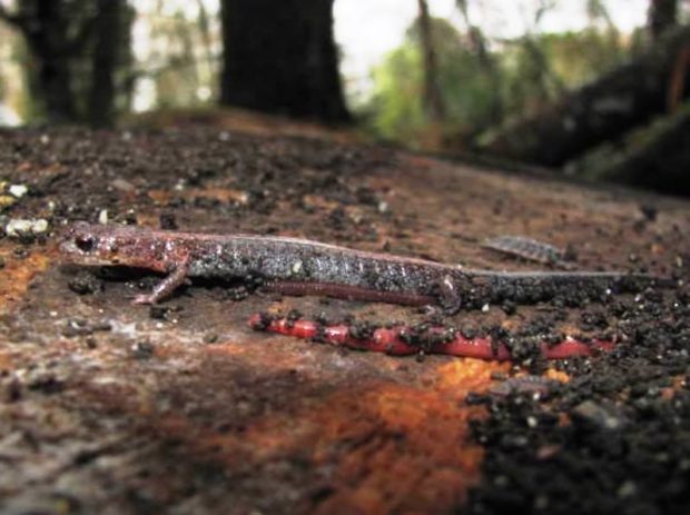
     Maine is home to a wide variety of wildlife including eight species of turtles, according to the Maine Herpetological Society. Several are considered common (widespread and not in danger): Eastern Painted, Midland Painted, Northern Snapping, and Musk turtles. Some are considered of special concern: Spotted and Wood turtles.  The endangered turtles are…

Amphibians

Amphibians, part of Maine’s wildlife population, are cold-blooded vertebrate (having a backbone) animals usually living on land but breeding in water, where their offspring change into adults. Salamanders An example of a Maine amphibian is the Spotted Salamander. It breeds in vernal pools (pools that have water in the spring but dry up later in…

West Bath

West and mostly south of Bath, it is bounded by the New Meadows River on the west and has several deeply indented coves on its south end. See photos. Although the town’s rural tradition is still evident in its buildings and remaining farms, much of the community is influenced by its extensive coastline, which is well protected from open ocean storms. Between Bath and Brunswick on the “by pass” limited access highway, West Bath is easy to miss but has more to offer than meets the fleeting eye.

Weather, Severe Events

Blizzards, floods and hurricanes are occasional weather events, but often sudden and severe in Maine. This is a chronicle of some of the most significant events. Blizzards November 26, 1898 was the first day of the two-day Portland Gale, a hurricane and blizzard that raged for over thirty-six hours sinking about one hundred vessels including…

Turner

Sunset view from Lower Street (2004)

Turner (see photos and video) lies directly north of Auburn on Maine Route 4, and is served by routes 117 in the south and 219 in the north. South Turner is a smaller village near the Auburn city line. Bounded by the Androscoggin River on the east, Turner has its share of ponds, including Bear Pond and its amusement park.

Stacyville

Mount Katahdin and Hunt Mountain from Swift Brook Road in Stacyville (2017)

Its main village is Sherman Station on the Bangor and Aroostook Railroad line and Maine Route 11 just across the town line from the Town of Sherman. Stacyville Village is in the southwest of the township; Siberia village is in the center on the Grindstone Road. That portion of Route 11 in Sherman Station Village serves as the “Main Street” for the town, with community buildings and businesses.

Sorrento

Sorrento Harbor (2004)

Sorrento sits on Waukeag Neck, on Maine Route 185 south of Sullivan. See photos. The neck juts into Frenchman’s Bay with spectacular views of the mountains in Acadia National Park. Sorrento Harbor is a centerpiece of the community, especially when the “summer people” return and the water fills with pleasure boats. The town hosts two nature preserves in Sorrento Harbor, both maintained by the Nature Conservancy: Dram Island, is home to nesting osprey; Preble Island is densely forested with eagles roosting.

Signs of Maine

Sign for the U.S. Customs Inspection Station on Route 167 in Fort Fairfield

When John Steinbeck was traveling the country in 1960, he noted that states had interesting differences expressed in their signs: The New England states use a terse form of instruction, a tight-lipped, laconic style sheet, wasting no words and few letters. . . . I am an avid reader of all signs, and I find…

Sanford

Sanford, with Springvale Village, is the seventh largest town or city in Maine by population according to the 2010 Census, up from a ranking of ninth in 1990. Traditionally an industrial town, primarily with textile mills and shoe making, Sanford has diversified and continues to be a growing community.

Rivers

Kennebec River (2002)

  Water abounds in Maine. It has 73 rivers longer than 20 miles, 39 rivers that drain at least 200 square miles, 51 lakes that have an area of at least five miles, 32 civil divisions that contain at least 5,000 acres of water, and 3,478 miles of coastline. Drainage areas (see below) are the…

Reed Plantation

House with Maple Sugar Shack "Crest Maple Farm" on Route 171 in Reed Plantation (2014)

The village is located on Maine Route 17 near the Mattawamkeag River and on the Wytopitlock stream. Other than Route 17, which runs through the through the western portion north to U.S. Route 2A, the Bancroft Road travels northeast from Wytopitlock to the Bancroft town line. These are the only improved roads. Two lots of Maine Public Reserved Land lie within the plantation: the 996-acre Thompson Deadwater Lot and the 539-acre Central-Wytopitlock Lot.

Pownal

Location Map for Portland

Bradbury Mountain State Park offers picnicking, a modest walk to the summit, and a historic cattle pound. See video and photos. “Pineland Center ” is a community of non-profits and local businesses. Most of the town is rural residential, with homes and a few farmhouses widely spaced along the local roads. The few commercial establishments are clustered in Pownal Center Village.

Potatoes

Potato Pickers (c. 1950)

I saw mountains of potatoes–oceans–more potatoes than you would think the world’s population could consume in a hundred years. –Steinbeck These girls, probably in the 1950’s, had been hand-picking potatoes, then carrying their baskets to the barrels. The small card, or “ticket” on each barrel identifies the picker by number. The number of completed barrels…

Pilgrims

“In the fall of 1620 the Pilgrims landed at Plymouth during a disagreeable storm, and, noting the excellent opportunity for future misery, began to erect a number of rude cabins.”  — Bill Nye Members of the Plymouth Colony began trading with fishermen and Indians in Maine within a few years of their arrival in 1620.…

Peru

Apparent Horse Cemetery on the Ridge Road (2013)

The town is on the south bank of the Androscoggin River just below the Rumford-Mexico-Dixfield area. Its main village is West Peru, across the river from Mexico in the northern portion of the town. See photos. Further south on the Ridge and Valley roads, the rolling rural landscape reveals mountain views, farms and forests. A campground and bed & breakfast may be found at the three-mile long Worthley Pond.

Northeast Harbor

The Sunbeam at its Berth (2001)

is a community in Hancock County within the town of Mount Desert. Its namesake harbor sits at the northeast side of the entrance to Somes Sound, which splits the island of Mount Desert. Routes 3 and 198 serve the village, passing Upper Hadlock Pond in Acadia National Park.  The pond had been a source of…

New Portland

Bridge over the Carrabassett River in New Portland (2017)

North New Portland hosts Morton’s Country Store, the Community Church, and Chase Memorial Hall. This village lies at the junction of routes 146 and 16, with Gilman Stream, and its Dam, flowing through it. See photos. The Carrabassett River, with its spectacular rocky bed, passes through East New Portland Village and under an arch bridge.

Moxie Gore

Small Village on the Lake Moxie Road in Moxie Gore (2019)

Moxie Gore is an unorganized township in Somerset County bordering the east bank of the Kennebec River just above The Forks Plantation.  Its odd shape earns it the name “Gore.” Moxie Stream is the outlet for Moxie Pond, which straddles The Forks and East Moxie Township to the southeast. Before joining the Kennebec River, the…