
Location Map for Shapleigh
| Year | Population |
|---|---|
| 1970 | 559 |
| 1980 | 1,370 |
| 1990 | 1,911 |
| 2000 | 2,326 |
| 2010 | 2,668 |
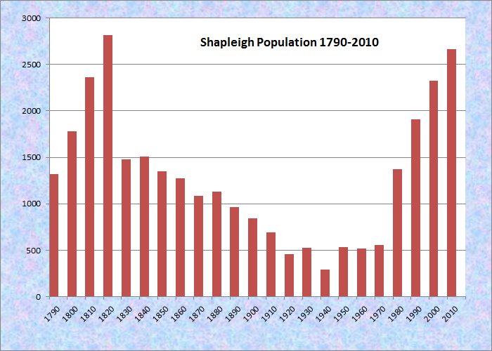
Population Trend 1790-2010
| Geographic Data | |
|---|---|
| N. Latitude | 43:33:09 |
| W. Longitude | 70:50:21 |
| Maine House | Dist 20,21 |
| Maine Senate | District 33 |
| Congress | District 1 |
| Area sq. mi. | (total) 41.2 |
| Area sq. mi. | (land) 38.8 |
| Population/sq.mi. | (land) 68.8 |
County: York
Total=land+water; Land=land only |
|
")
North Shapleigh Baptist Church (2012)
")
Shapleigh General Store (’12)
[SHAP-lee] is a town in York County, settled in 1772 and incorporated on March 5, 1785 from Shapleigh Plantation, once known as Hubbardstown. Shapleigh swapped land with Sanford (1787, 1820), with Lebanon (1793, 1825), and with Acton (1830, 1831). Finally, it ceded land to Newfield in 1846 and annexed land from Waterborough in 1854 to complete its modern boundaries.
After reaching an historic low of number residents in 1940 at 290, the town had nearly ten times that population in 2010, rivaling its 1820 high of 2,815.
")
Shapleigh Post Office (2012)
")
First Baptist Church (’12)
Named for Nicholas Shapleigh, a landowner, the town is bordered on the west by Square Lake and Mousam Lake. Maine Route 11 moves up from Sanford through the villages of Emery Mills, Shapleigh, and North Shapleigh near the lake shores.
")
Veterans Memorial near the Commons (2012)
")
1866 Washington School in North Shapleigh (2012)
Shapleigh was first settled in 1772. In that year Simon Emery established a sawmill near what is now Emery Mills village. In the 1880’s, North Shapleigh had its own sawmill, a woolen mill, and a leather board factory. Hargraves Woolen Mill, established in 1844, was a custom carding and woolen mill. Later it produced blue blouse flannels (possibly Civil War uniforms), and cashmere. At one point it employed from 60-75 people. The Mill, closed in 1904, was demolished in 1928.
The Shapleigh Woods, managed by The Nature Conservancy, is a 265-acre preserve that ensures protection for one of the world’s largest known populations of the federally endangered small whorled begonia.
Form of Government: Town Meeting-Select Board.
More Videos!
Additional resources
Goodwin, Esther E. Acton and Shapleigh, Maine – Past & Present. Shapleigh, Me. Acton-Shapleigh Historical Society. 1976. [University of Maine at Farmington, Mantor Library]
Hobbs, Theodore B. Diary, 1920. (Cataloger Note: Theodore B. Hobbs, born about 1852, was a resident of Emery Mills, a locality in Shapleigh, Maine. A daily diary kept by Hobbs in which he recorded the weather, family activities, and the work he did both for himself and for others.) [University of Maine, Raymond H. Fogler Library, Special Collections]
Loring, Amasa. A History of Shapleigh. Springvale, Me. Harland H. Eastman. 1983.
Petersen, Debbie. Shapleigh and Acton. Charleston, SC. Arcadia Publishing. 2010.
Shapleigh Bicentennial Committee (Me.) A History of Shapleigh, Maine: Prepared on the occasion of the Bicentennial of the town, incorporated 1785-1985. Shapleigh, Me. The Committee. 1985. (Sanford, Me. : Wilson Printers)
Varney, George J. A Gazetteer of the State of Maine. 1886. p. 508-509.
| heodore B. Hobbs, born about 1852, was a resident of Emery Mills, a locality in Shapleigh, Maine | |
| A daily diary kept by Hobbs in which he recorded the weather, family activities, and the work he did both for himself and for others |