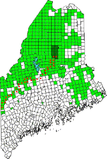
Vacant Housing Units

Map: Percent of Housing Units Vacant 2005-2009

During the period 2005 through 2009, housing unit vacancy rates varied widely from 10% in Androscoggin County to over 46% in Washington County.  This represents a slightly decreased disparity compared to the 2000 Census range for Maine, which was from 8.6% to 47.2%. Sources: Year 2000 map – http://factfinder.census.gov/servlet/ThematicMapFramesetServlet?-geo_id=04000US23&-tm_name=DEC_2000_SF1_U_M00200&-ds_name=DEC_2000_SF1_U 2005-2009 map: http://factfinder.census.gov/home/saff/main.html?_lang=en

Median Value of Housing Units

Map: Median Value of Housing Units 1990

The value of housing tells a lot about income and the competition for housing in a particular area. For nearly three decades the coastal counties (except for Washington) have registered higher housing values, while the northern counties and Washington County have had the lowest. During the 2005-2009 period, the distribuion has generally held to the…

Native Americans by County, Percent

Map: Native Americans by County 2010

In 2010 the three counties in which Indian reservations exist had the largest proportion of Native American residents.  Washington leads with 4.5 percent of the county’s population.  Aroostook (1.5%) and Penobscot (.9%) follow.  The Native American population statewide is 0.6%. County Percent Washington 4.5% Aroostook 1.5% Penobscot 0.9% Piscataquis 0.6% Kennebec 0.5% Somerset 0.5% Androscoggin…

Franklin County Nature Preserves

Pond in Bigelow Preserve (2003)

Bald Mountain Public Reserved Land, Rangeley. Bald Mountain’s one mile trail to the summit offers panoramic views of Rangeley, Cupsuptic and Mooselookmeguntic lakes and the Height of Land. Especially popular in the fall with autumn colors, the area contains more than 200 species of wildlife in its 1,873 acres. A short trail leads to the…

TA R10 WELS

Area of TA R10 Township as represented in the 1952 Topographic Map.

                  Area of TA R10 Township as represented in the 1952 Topographic Map. This township is immediately adjacent to T1 R11 WELS, host to the next northerly section of the AT. The trail generally tracks east-west, except for a short northwest-southeast section between Mud Pond and Lower…

TA R12 WELS

1952 TA R12 Topographic Map

The township is immediately adjacent to T1 R11 WELS, host to the next northerly section of the AT. The Appalachian Trail cuts briefly through the southeast corner of the township, also known as Shawtown. Shawtown is a very watery township, with four of the Roach Ponds and First, Second, Third, and Fourth West Branch Ponds.…

TB R11 WELS

A view from the ridges in TB R11 WELS 2007

          A view from the Appalachian Trail on ridges in TB R11 WELS (2007) This township, in Piscataquis County, is immediately southeast of TA R12 WELS, host to the next northerly section of the Appalachian Trail. The AT briefly (about two miles) passes through the northwest corner of the township as…

T7 R9 NWP

Historic Topographic Map of T9 R9

This township is immediately south of the Bowdoin College Grant East, host to the next northerly section of the AT. The Trail (red dots on the maps) runs from East Chairback Pond, over Chairback Mountain, past West Chairback Pond to Third Mountain and Fourth Mountain in the western edge of the township. In the 1940’s…

Sandy River Plantation

Mountain Ranges from the Saddleback Mountain Trail on the AT (2004)

About 35 miles northwest of Farmington on Maine Route 4, just south of Rangeley, the community marks the source of the Sandy River in the Sandy River Ponds. See map, video and photos. Four Ponds Public Reserve Land lies just east of Mooselookmeguntic Lake. Access is by the Appalachian Trail off Route 4 in Sandy River.

Township C

Detail of 1940

     Detail of 1940’s Township C Topographic Map This oddly shaped, [click Location Map for red location] trapezoidal township, not to be confused with the triangular C Surplus, is immediately west of Township D, host to the next northerly section of the Appalachian Trail. The trail travels about one mile in the township’s southeast…