Washington County

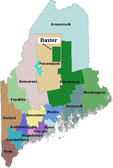
Map of Maine Counties and Baxter Park

Washington is the fourteenth most populous of the sixteen counties, located on the eastern most coast of Maine. It was formed on May 1, 1790 comprising all land west from the St. Croix River to the then eastern boundary of Hancock County. Only one town, Machias, existed within its boundaries. The county lost half its…

Waldo County

Map of Maine Counties and Baxter Park

is the eleventh most populous of the sixteen counties, located in mid-coast Maine, and was formed on July 3, 1827 from portions of Hancock, Kennebec, and Lincoln counties. Several adjustments were made in the 19th century, resulting in the current boundary containing the City of Belfast and the towns of Belmont, Brooks, Burnham, Frankfort, Freedom,…

Somerset County

Map of Maine Counties and Baxter Park

    A series of boundary changes in the 19th century came to an end in 1885 when a portion of Wellington in Piscataquis County was annexed to Cambridge in Somerset. The county now consists of the towns of Anson, Athens, Bingham, Cambridge, Canaan, Caratunk, Cornville, Detroit, Embden, Fairfield, Harmony, Hartland, Jackman, Madison, Mercer, Moose…

Sagadahoc County

Map of Maine Counties and Baxter Park

is the twelfth most populous of the sixteen counties, located in southern mid-coast Maine. Formed on April 4, 1854 from a portion of Lincoln County. All its initial municipalities still comprise the county: the City of Bath and the towns of Arrowsic, Bowdoin, Bowdoinham, Georgetown, Perkins, Phippsburg, Richmond, Topsham, West Bath, Woolwich. The only exception…

Piscataquis County

Map of Maine Counties and Baxter Park

is the least populous of the sixteen counties, located in north central Maine. Formed on April 38, 1838 from portions of Somerset and Penobscot counties. Initially it had twenty-two towns, two more were incorporated later, Dover and Foxcroft combined, and seven towns surrendered their organization, becoming townships. The well-known Baxter State Park is located on…

Penobscot County

Map of Maine Counties and Baxter Park

is the thirdlargest in population of the sixteen counties, located in east central Maine, bisected by the Penobscot River and, the newer avenue of transportation, Interstate 95. Formed on April 1, 1816 from the northern part of what was then Hancock County, it later gave up territory to form Piscataquis and Aroostook counties. As with…

Oxford County

Map of Maine Counties and Baxter Park

Oxford County is the seventh largest in population of the sixteen counties, located in western Maine along the New Hampshire border to the east and the Province of Quebec border to the north. The northern parts of York and Cumberland counties were separated to form Oxford County on March 5, 1805.  As with many counties,…

Lincoln County

Map of Maine Counties and Baxter Park

is the thirteenth largest in population of the sixteen counties, located in mid-coast Maine. Its early history is well described as follows: Lincoln County was the most easterly of the two counties established, June 21, 1760, when York County was first divided. Its western boundary started at the eastern extremity of Casco Bay to New…

Knox County

Map of Maine Counties and Baxter Park

is the tenth largest in population of the sixteen counties, located in mid-coast Maine and home to about twenty moderate-sized islands, the largest of which are Vinalhaven, North Haven, and Isle Au Haut. It was formed on April 1, 1860 from parts of Lincoln and Waldo counties. The county currently consists of the city of…

Kennebec County

Map of Maine Counties and Baxter Park

is the fourth largest in population of the sixteen counties, located in central Maine and bisected by the Kennebec River. It was formed on February 20, 1799 from the northern part of Lincoln County.  It lost a large part of its original northern portion when Somerset County was created on June 1, 1809. At least…

Hancock County

Map of Maine Counties and Baxter Park

Hancock County is one of two downeast coastal counties located east of the Penobscot River. It was formed when the extensive Lincoln County split on June 25, 1789 by adding Hancock and Washington counties. The westerly portion of the new Hancock County was eventually split off to form Waldo County. See an 1860 map of…

Franklin County

Map of Maine Counties and Baxter Park

located in west central Maine, was formed from towns and land previously belonging to Kennebec, Oxford, and Somerset counties on May 9, 1838. Smaller adjustments were made during the following fourteen years. See an 1861 map of the county in the Map Cabinet. The county extends from Chesterville, New Sharon, and Farmington in the south,…

York County

Map of Maine Counties and Baxter Park

was Maine’s first county, established November 20, 1652, by the Massachusetts act that also incorporated the town of Kittery.  The county included all of the land claimed by Massachusetts beyond the Piscataqua River, which now defines the southern boundary of Maine with New Hampshire. In 1674, the jurisdiction of Massachusetts was extended to Muscongus Bay,…

LePage, Paul R.

Paul R. LePage (governor

(from the governor’s official internet site, April 25, 2011) Paul LePage has spent most of his life tackling one challenge after another, the kinds of challenges that defeat most people. The oldest son of eighteen children in an impoverished, dysfunctional family, Governor LePage left home at the age of eleven to escape domestic violence and…

King, Angus S. Jr.

Governor King and his wife, Mary Hermon (2002)

(1944- ) was born on March 31st, 1944, in Alexandria, Virginia, was president of two of his classes at the local high school, graduated from Dartmouth College in 1966 and the University of Virginia Law School in 1969. While in high school, he attended Martin Luther King, Jr.’s “March on Washington” on August 28, 1963,…

Brennan, Joseph E.

Joseph E. Brennan

(1934- ) was a U.S. Representative born in Portland on November 2, 1934. He attended public schools, then received a B.S. from Boston College in 1958, and an LL.B. from the University of Maine Law School in 1963. State public service began as a member Maine House of Representatives (1965-1971), followed by terms in the…

Longley, James B. Sr.

James B. Longley, Sr. in the governor

(1924-1980) born in Lewiston, attended public schools, Bowdoin College, and received a law degree from the University of Maine in 1957. After his service with the Army Air Corps during World War II, he returned to enter the insurance business and became quite successful with his form Longley Associates. He served Governor Kenneth Curtis chairing…