Franklin County

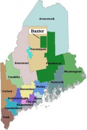
Map of Maine Counties and Baxter Park

located in west central Maine, was formed from towns and land previously belonging to Kennebec, Oxford, and Somerset counties on May 9, 1838. Smaller adjustments were made during the following fourteen years. See an 1861 map of the county in the Map Cabinet. The county extends from Chesterville, New Sharon, and Farmington in the south,…

York County

Map of Maine Counties and Baxter Park

was Maine’s first county, established November 20, 1652, by the Massachusetts act that also incorporated the town of Kittery.  The county included all of the land claimed by Massachusetts beyond the Piscataqua River, which now defines the southern boundary of Maine with New Hampshire. In 1674, the jurisdiction of Massachusetts was extended to Muscongus Bay,…