T1 R5 WELS

Gulliver Brook crossing U.S. Route 2 in T1 R5 WELS in Autumn (2014)

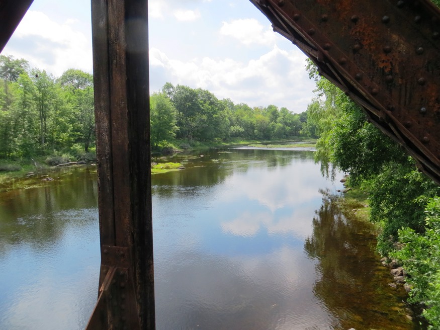
This sparsely populated township lies south of Benedicta and Silver Ridge Townships. The Aroostook Road from Benedicta to Molunkus village is the primary improved road, passing through the center of the township.  A small slice of the Nine Mile Woods Road (U.S. Route 2) cuts through its northeast corner. With frontage on two relatively remote…

Silver Ridge TWP

Logging Truck on 07-00-0, a dirt road in Silver Ridge off the 6000 Road (2014)

Silver Ridge was, once a plantation from 1878 to the 1950s, in Aroostook County, immediately south of Sherman and east of Benedicta Township. Its small and declining population was likely a major factor in surrendering its organization. It is now an unorganized township.  Township population counts are not usually separated from other nearby townships. Both…

Winn

Location Map for Winn

Winn village is on U.S. Route 2 between Lincoln and Mattawamkeag on the east bank of the Penobscot River. See photos. During the 19th century, International Paper Company harvested wood to supply its pulp and paper mills. Winn is an agricultural community slowly losing its small population as are many northern Maine towns.

Wilton

Location Map for Wilton

Located on the shore of Wilson Pond, the main village lies at the intersection of U.S. Route 2 and Maine Routes 4 and 156.. See photos. George H. Bass began making boots for farmers in 1876. For more than 100 years, the G. H. Bass company made footwear in Wilton.

Veazie

Veazie Dam on the Penobscot River (2003)

At only 3.4 square miles in area, Veazie is one of the smallest municipalities in the state. U.S. Route 2 is also its Main Street. Created in 1853, it was named, and likely created, for General Samuel Veazie who owned the saw mills and most of the property in the new town. Mills and a power station took advantage of the Penobscot River here.

Smyrna

Farm Buildings in Smyrna (2003)

Named for a famous city in ancient Turkey, the town is west of Houlton on Interstate 95 and on U.S. Route 2, where the village of Smyrna Mills straddles the town line with Merrill. See photos. The town has become home to a substantial number of Amish people, who farm and work using simple, low technology methods. The Mattawamkeag River flows through the village. In the river is the ruins of an old dam and mill.

Rumford

Deacon Hutchins House (1979)

Year Population 1970 9,363 1980 8,240 1990 7,078 2000 6,472 2010 5,841 Geographic Data N. Latitude 44:31:19 W. Longitude 70:35:50 Maine House District 115 Maine Senate District 18 Congress District 2 Area sq. mi. (total) 69.9 Area sq. mi. (land) 68.6 Population/sq.mi. (land) 85.2 County: Oxford   Total=land+water; Land=land only [RUM-frd] a town in Oxford…

Pittsfield

Pittsfield 1889 "Bird

Maine Central Institute, founded in 1866 as a preparatory school for Bates College, is one of the “Big 10” private secondary schools in Maine that still serves the public school population as well. See photos. Downtown Pittsfield, on the Sebasticook River, was wiped out by a fire in 1881 and rebuilt immediately. As did many Maine communities, Pittsfield’s woolen mills provided steady employment during the first half of the 20th century, then literally “went South,” finding cheaper labor in the 1950’s.

Passadumkeag

Passadumkeag River from the Railroad Bridge (2012)

The current village of Passadumkeag includes a small residential area east of U.S. Route 2. A community center (in a Quonset building), fire station, historical society, town office, post office, and the Passadumkeag Baptist are all on or near Pleasant Street in this small village.

Palmyra

Location Map for Palmyra

The Sebasticook River passes through Douglas Pond at the south end of the town, just above Pittsfield. A golf course and campground is adjacent to White Pond, in the eastern portion of the town, where a “hand-carry” boat launch is available. The Madawaska Wildlife Management Area straddles Madawaska Brook and encompasses the Madawaska Marsh.

Old Town

The town is heavily influenced by the nearby University of Maine, and the long-lived Old Town Canoe Company maintains an outlet that attracts customers with a broad range of outdoor recreation interests. See photos. DeWitt Field, Old Town’s municipal airport, hash three runways. Since 1669, the area has been the principal home of the Penobscot Indians.

Newry

Built in 1872, the Sunday River Bridge, called “he most painted and photographed covered bridge in the state,” crosses the river of the same name. See photos. The Sunday River Ski Resort is located here. On Maine Route 26, Newry is the gateway to the hiking trails, including the Appalachian Trail, of Grafton Township. Step Falls Preserve, the first preserve of the Maine Chapter of the Nature Conservancy, has 24 acres of cascades and pools.

Newport

Bird in its safe habitat near the Sebasticook River in North Newport (1014)

Newport features the six-mile long Sebasticook Lake, providing recreational opportunities for residents and summer visitors. Drought conditions in 2002 lowered the water level substantially. See photos. Prior to the opening of what became the Maine Central Railroad in 1855, Newport was a center of stage coach transportation. Newport is still a heavily traveled crossroads, now of Interstate 95, U.S. Route 2, and Maine Routes 7, 11, and 100. The area east of Sebasticook Lake is known as East Newport.

New Sharon

1916 Bridge over the Sandy River in New Sharon (2003)

just east of Farmington, has been growing consistently in population over the past four decades. New Sharon village straddles the Sandy River, which winds through from Farmington on its way to Starks and then Norridgewock where it enters the Kennebec River. The 1916 steel bridge, now retired from service, crosses the river at the end of the main street.

New Limerick

Cottages in New Limerick at Nickerson Lake (2012)

In the 1880’s the town had a large tannery, two saw mills, and a starch factory. It has frontage on Drew and Nickerson lakes, along with a half-dozen small ponds. See photos. The main village of the town, just west of Houlton, nearly surrounds Nickerson Lake, which it shares with Linneus. It is the birthplace of Dora Pinkham, the first woman to served in the Maine Legislature.

Milford

Sunkhaze Stream near U.S. Route 2 (2005)

The Bodwell Water Power Company Plant is a historic structure and landmark on the banks of the Penobscot River. The Sunkhaze Meadows National Wildlife Refuge combines bog, marsh, floodplain forest and the state’s second largest peatland. The town, across the river from Old Town, is a moderately growing residential area near the greater Bangor area and the University of Maine in Orono.

Mexico

Stack of Paper Mill in Rumford near the Androscoggin River from the Mexico-Rumford Bridge (2013)

The town, across the Swift River and the Androscoggin River from Rumford, is home to many workers in the Rumford paper mill. See photos. In the 1960’s, the mill employed over 3,000 people; by 2009 it employed less than 600. The crash in this and other manufacturing has contributed to the sharp population decline Mexico has experienced since 1970.

Macwahoc

The name (the Indian term for “bog” or “wet ground”) is appropriate since the main village lies at the north end of a bog on Molunkus Stream. See photos. The township has some frontage on Molunkus Lake. A 485 acre section of Maine Public Reserved Land is here.