Passadumkeag River from the Railroad Bridge (2012)

Location Map for Passadumkeag
| Year | Population |
|---|---|
| 1970 | 326 |
| 1980 | 430 |
| 1990 | 428 |
| 2000 | 441 |
| 2010 | 374 |
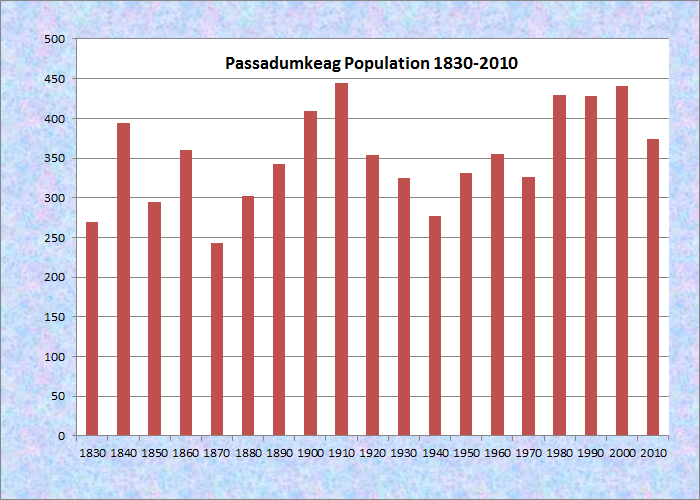
Population Trend 1790-2010
| Geographic Data | |
|---|---|
| N. Latitude | 45:11:01 |
| W. Longitude | 68:35:25 |
| Maine House | District 137 |
| Maine Senate | District 5 |
| Congress | District 2 |
| Area sq. mi. | (total) 23.1 |
| Area sq. mi. | (land) 22.9 |
| Population/sq.mi. | (land) 16.3 |
County: Penobscot
Total=land+water; Land=land only |
|
 N45° 12' 30.7\" W68° 37' 33.9\"")
@
[Pass-ah-DUM-keg]is a town in Penobscot County, incorporated on January 31, 1835 from the township known as the Old Indian Purchase, east of the Penobscot River, or OIP, EPR. In 1842 it ceded land to Lowell.
An ancient “cemetery” about 3,000 years old is located in the town.
")
Passadumkeag River Entering the Penobscot River (2001)
 N45° 11' 9.06\" W68° 37' 0.1554\"")
Boat Launch on the Penobscot River (2012) @
The native name means “above the gravel bar” or “where the river runs over the gravelly bed.”
The gravel referred to is downstream in the Penobscot River, just above which is the entrance to Passadumkeag River (earlier called “stream”), a vital link to the east by canoe.
The village itself is at the junction of the two rivers.
According to the Gazetteer of Maine in 1886, the village was described as follows:

Passadumkeag on the River
There is here a large steam-mill, manufactur- ing large lumber, boards, shingles and staves. Other manufactures are coopers’ ware, carriages, etc. Farming and lumbering are the chief occupations of the people.
")
Passadumkeag Baptist Church (2012)
")
Post Office (2012)
The current village of Passadumkeag includes a small residential area east of U.S. Route 2.
A community center (in a Quonset building), fire station, historical society, town office, post office, and the Passadumkeag Baptist are all on or near Pleasant Street in this small village.
The railroad that serves norther Penobscot and southern Aroostook county passes through the village and over the Passadumkeag River.
 N45° 11' 5.9\" W68° 36' 47.7\"")
Community Center and Fire Station (2012) @
 N45° 11' 6.3\" W68° 36' 50.6\"")
Historical Society on Pleasant Street (2012) @
 N45° 11' 6.1\" W68° 36' 48.1\"")
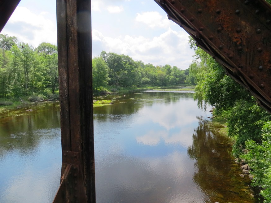
Bridge over Passadumkeag River (2012) @
 N45° 11'4.3\" W68° 36' 48.1\"")
The Passadumkeag from the Bridge (2012) @
Form of Government: Town Meeting-Select Board.
Additional Resources [Click on images to enlarge and clarify]
Chadbourne, Ava Harriet. Maine Place Names and The Peopling of its Towns.
Eckstorm, Fannie Hardy. Indian Place Names of the Penobscot Valley and the Maine Coast.
*United States. Department of the Interior. National Park Service. “District #2 School.” https://npgallery.nps.gov/pdfhost/docs/nrhp/text/97000309.PDF (accessed March 5, 2017)
Varney, George J. A Gazetteer of the State of Maine. 1886. p. 429-430.
National Register of Historic Places – Listings
District No. 2 School
[junction of Pleasant Street and Caribou Road, southeast corner; see photo above right “Passadumkeag Historical Society on Pleasant Street” (building on left)] Built sometime between 1843 and 1849, the District #2 School is a one-story frame building that has been used historically as a church, town hall, and library, in addition to a schoolhouse. This unusual pattern is reflected in the building’s features including the church-like bell tower and spire, and the front porch and interior finish that dates to the period of library use.
The first known reference to the school in District #2 is a warrant that was presented at the March 31,1843 town meeting. Warrant 25 asked the residents assembled “To see what method the Town will take to have a School House built in District No.2.” No further reference is made to the school in the town records until September of 1849 when a town meeting was adjourned “…to the New School House.” Thus, sometime between 1843 and 1849 a school was built in District No. 2, which embraces the village of Passadumkeag.
In addition to its original use as a school, the building served as the meeting place for the local Congregational Church and later the Baptist Church until 1905 when a new Baptist church building was erected in town. The question of when the religious function started is important because it most certainly relates to the date of construction of the tower. In scale, the tower is out of proportion to the typically sized schoolhouse. Nonetheless, its design and detailing, in particular the Gothic Revival style spirelets, suggest that it dates to the 1840s or 1850s.The school’s educational use appears to have been uninterrupted from its date of construction until 1902 when a new facility was built in the village. In addition, until a new town hall was erected in 1889, the schoolhouse served as the town meeting place. In 1915 it was converted into a town library by the Passadumkeag Improvement Club, at which time several changes were made including the addition of the front porch and the application of decorative steel sheathing to the interior walls and ceiling. From 1946 until 1968 it was once again used as a school, initially for grades K-3 and later K-2 and then K-l.
In 1971 it was sold and converted to a residence. The town reacquired the building in 1986 and then gave it to the Passadumkeag Historical Society [see photo above] which has converted it into a museum. Passadumkeag’s District #2 School has an unusually long and varied history, making it truly worthy of the term “multi-purpose building.” These associative relationships with local education, town government, religion, and early twentieth century village improvement efforts clearly establish the building’s significance.*