Blake Gore

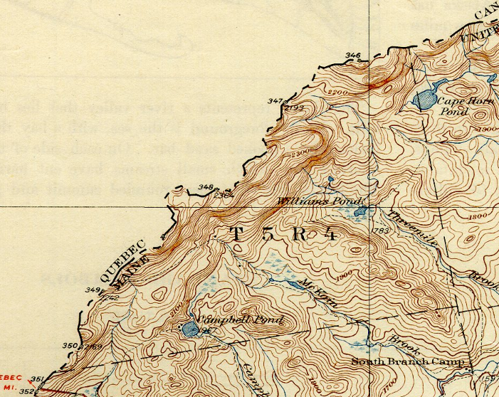
This small township is at the extreme west of the State.  A gore is an area, triangular or irregular in shape, formed by the diverging or converging survey lines, often as a result of inaccuracies. This township in Somerset County shares an irregular, meandering border in a mountainous area with the Canadian province of Quebec.…

Brewer

Brewer Along the Penobscot (2003)

Year Population 1970 9,300 1980 9,017 1990 9,021 2000 8,987 2010 9,482 Geographic Data N. Latitude 44:46:44 W. Longitude 69:25:29 Maine House Dists 128,129 Maine Senate District 8 Congress District 2 Area sq. mi. (total) 15.6 Area sq. mi. (land) 15.1 Population/sq.mi. (land) 628.0 County: Penobscot Total=land+water; Land=land only  Brewer is a city in Penobscot…

Logging in Maine

Hunt Sawmill in Jefferson (2012)

The cutting and moving of logs destined for lumber or paper was a tough, manual effort until the second half of the 20th century. Here is an eyewitness assessment by Louise Dickenson Rich of logging camp life in the 1940’s near Middle Dam in western Maine. I also had to learn to differentiate between a…

T3 R7 WELS

East of Baxter Park, it is home to Katahdin Woods & Water Recreation Area, Sandbank Campsite, Wassataquoik Public Reserved Land, and Whetstone Falls. West of Stacyville, access is by Swift Brook Road and a network of dirt roads.

Penobscot River

Grand Lake Matagamon from the Baxter Park Access Road before the Matagamon Gate

Windows on the River: East Branch Windows on the River: West Branch The Penobscot River Basin drains 8,680 +/- square miles in northeastern Maine. The main stem of the river flows for 105 miles from the confluence of its East and West Branches in Medway, south to its mouth in Penobscot Bay. Approximately 95% of…

Pittston Academy Grant

Pittston Farm Sign on the Northern Road (2008)

This township is mostly south of the Golden Road where the Northern Road turns down toward the Pittston Farm, established by the Great Northern Paper Company. According to John Gould, In lumber camp lingo a “farm” is a depot and base of operations serving a considerable area of working timberland.  Pittston Farm had storage sheds,…

Woodville

Woodville Town Office on Route 116 in South Woodville (2020)

The town dominates the west side of the great bend in the Penobscot River just south of Medway where the East and West branches combine. Maine Route 116 leaves the River in Chester and cuts through Woodville to Medway.

Winterport

Marsh Bay on the Penobscot River just South of Winterport Village (2003)

Winterport is primarily a rural community with its land area extending ten miles westward from the river. See photos. An attraction along Route 139 among the farms and woods is the Winterport Dragway, featuring auto drag races with specialty vehicles and “street” vehicles. In recent years a marina has expanded and an export business has been established on the river. A dockside freezer operation enabled the storage and shipping of commodities such as fish and chicken.

Verona Island

is located on an island in the Penobscot River between the towns of Prospect and Bucksport. The Island is bounded by the Main and the Eastern Channels of the Penobscot. The Eastern is supplemented with the outlet of the Orland River. The old Waldo-Hancock Suspension Bridge provided the link from the Town of Prospect as U.S. Route 1 and Maine Route 3 pass through the town to Bucksport, then “Downeast” to Bar Harbor and Calais. The bridge was replaced by the new Penobscot Narrows Bridge in 2007.

Veazie

Veazie Dam on the Penobscot River (2003)

At only 3.4 square miles in area, Veazie is one of the smallest municipalities in the state. U.S. Route 2 is also its Main Street. Created in 1853, it was named, and likely created, for General Samuel Veazie who owned the saw mills and most of the property in the new town. Mills and a power station took advantage of the Penobscot River here.

Northeast Carry

Moosehead Lake and Seboomook Wilderness Campground (2008)

Northeast Carry is a township on the northeast shore of Moosehead Lake, with a view of Mount Kineo (photo on left below – sharp cliff right of center). It connects the Lake with the West Branch of the Penobscot River by a “carry” corridor for portaging canoes. Henry David Thoreau used this connector twice during…

Prospect

on the west bank of the Penobscot River, across from Bucksport, the main village is at the junction of Maine Route 174 and U.S. Route 1A, near the South Branch of the Marsh River. Prospect is home to Fort Knox, built in 1844 with Mount Waldo granite from Frankfort and named for Henry Knox, the first U.S. Secretary of War.

Penobscot

Penobscot River entering Penobscot Bay (2003)

The community takes its name from the Penobscot River, which forms its western boundary. See photos. In the late 19th century the town hosted a mining company, four wood-related mills, a meal and flour mill, and several manufacturers of clothing, barrels, carriages, harnesses and other items. Reached from Orland off U.S. Route 1, the town is served by Maine Routes 15, 175 and 199. Northern Bay, a major spur of the Bagaduce River, splits the southern end of the town.

Passadumkeag

Passadumkeag River from the Railroad Bridge (2012)

The current village of Passadumkeag includes a small residential area east of U.S. Route 2. A community center (in a Quonset building), fire station, historical society, town office, post office, and the Passadumkeag Baptist are all on or near Pleasant Street in this small village.

Old Town

The town is heavily influenced by the nearby University of Maine, and the long-lived Old Town Canoe Company maintains an outlet that attracts customers with a broad range of outdoor recreation interests. See photos. DeWitt Field, Old Town’s municipal airport, hash three runways. Since 1669, the area has been the principal home of the Penobscot Indians.

Michaud, Michael H.

Michael H. Michaud 2012

  Michael Michaud (1955- ) was a U.S. Representative first elected in 2002, then re-elected in 2004, 2006, 2008, 2010 and 2012. He was a Democratic State Senator Democrat from East Millinocket, unanimously elected Maine’s 107th Senate President on December 6, 2000 under the State Senate’s unique power sharing arrangement resulting from a first-ever partisan…

Mattawamkeag

Upper Gordon Falls on the Mattawamkeag River (2016) [See video]

The Mattawamkeag River, on which the town is located, is the largest eastern tributary of the Penobscot. See photos. The junction of the two rivers is marked by a gravel bar at the entrance to the Mattawamkeag. Thoreau, on his way to climbing Mount Katahdin, visited the area in 1847. Today, a 1,000 acre Wilderness Park is situated between the two rivers with campsites, fishing, swimming and hiking available.

Howland

Penobscot River South of Howland Village on Route 116 (2005)

Att the junction of the Piscataquis River with the Penobscot, and Seboeis Stream with the Piscataquis, it once had a thriving paper mill, The Advance Bag and Paper Company. See photos. The old mill remains empty. Maine Inland Fisheries and Wildlife supervises the Old Pond Farm Wildlife Management Area featuring eagles, osprey, deer, moose, and water birds.