![Upper Gordon Falls on the Mattawamkeag River (2016) [See video]](https://maineanencyclopedia.com/wp-content/uploads/160425-RW014-Copy.jpg)
Upper Gordon Falls on the Mattawamkeag River (2016) [See video]

Location Map for Mattawamkeag
| Year | Population |
|---|---|
| 1970 | 988 |
| 1980 | 1,000 |
| 1990 | 830 |
| 2000 | 825 |
| 2010 | 687 |
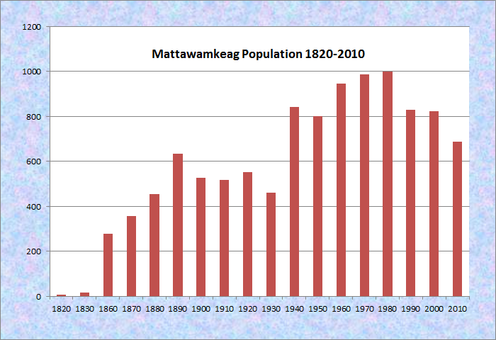
Population Trend 1820-2010
| Geographic Data | |
|---|---|
| N. Latitude | 45:33:02 |
| W. Longitude | 68:18:46 |
| Maine House | District 141 |
| Maine Senate | District 5 |
| Congress | District 2 |
| Area sq. mi. | (total) 39.5 |
| Area sq. mi. | (land) 38.9 |
| Population/sq.mi. | (land) 18.4 |
County: Penobscot
Total=land+water; Land=land only |
|
 N45° 32' 11.36\" W68° 20' 33.13\"")
@
[mat-ah-WAHM-keg] is a town in Penobscot County, incorporated on February 14, 1860 from Mattawamkeag Plantation on the site of an ancient Indian village.
The Mattawamkeag River, on which the town is located as it enters the Penobscot, is the largest eastern tributary of the Penobscot. The junction of the two rivers is marked by a gravel bar at the entrance to the Mattawamkeag, whose Indian name is often translated as “a river with many rocks at its mouth” or a similar phrase.
")
Mattawamkeag River nearing the Penobscot (2001)
")
Railroad Tracks and Mill (’01)
The area experienced early traffic on the river. A traveler arrived from St. John in 1624; English captive John Gyles was brought up the river in 1689.
Before 1812 a mill had been built, but it was burned by the Indians in that year.
The first settler, a Colonel Stanley, built a house in 1829, the year that the military road to Houlton had reached Mattawamkeag.
Henry David Thoreau, on his way to climbing Mount Katahdin, visited the area in 1847 and explored the areas frequented by Indians in earlier times.
 N45° 32' 11.36\" W68° 20' 33.13\"")
Town Office (2012) @
 N45° 31' 5.16\" W68° 21' 14.08\"")
Downtown (2012) @
 N45° 31' 5.16\" W68° 21' 14.08\"")
Post Office & Masons (’12) @
 N45° 31' 19.54\" W68° 21' 5.36\"")
Rt. 2, Mattawamkeag (2012) @
 N45° 31' 0.62\" W68° 21' 9.79\"")
United Church of Christ (’12)@
In 1878, young Theodore Roosevelt boarded the train at a small depot on his way to meet William Sewall in Island Falls. George Varney’s observations in the 1880’s are as follows:
The “Gordon Falls” extend for a considerable distance a long the Mattawamkeag, which, at this point, crosses the southern line of the town from different times. On the stream are a board, shingle, and lath mill, with planer. There are other manufactures common to country villages. The principal centre of business is near the mouth of the Mattawamkeag at the station on the European and American Railway, which here turns eastward along the north bank of the river. . . .
The town-hall is a neat, two-story, wooden building, having a school-room and dining-hall on the first floor. The Indians tell of a village and burial-place of their own on the north bank of the Mattawamkeag, near the present village; and some sonte-axes, arrow-heads and other relics have been found there.
")
Wilderness Park Road (2012)
 N45° 31' 38.48\" W68° 20' 53.49\"")
Entering Town from the North on Rt. 2 (2012) @
Today, a 1,000 acre Wilderness Park is situated between the two rivers with campsites, fishing, swimming and hiking available. The entrance is down the Park Road at N 45° 31’ 23.7” W 68° 16’ 17.8”. Nearby the Mattawamkeag River rages through a gorge featuring Class IV rapids.
The Mattawamkeag River is the longest river in Maine with effectively no regulation of its flow by dams. The river drains slightly over 1500 square miles, and the large basin size and high percentage of wetlands in the basin provides moderate flows even in the summer months. The U.S. Geological Survey maintains a stream gauge just below Lower Gordon Falls. Upper [N 45° 30’ 15.2” W 68° 17’ 48.9”] and Lower Gordon Falls [N 45° 30’ 18.4” W 68° 17’ 58”] on the River in Mattawamkeag and Winn are an excellent place to view several stretches of Maine whitewater rapids and examine water-worn potholes in the bedrock.
By law, the Mattawamkeag River from the Kingman-Mattawamkeag boundary to its confluence with the Penobscot River is defined as a Class AA river, the highest water quality classification for a river in Maine. The stretch of the Mattawamkeag River from Kingman to Mattawamkeag is rated as Class II – IV for canoeists and kayakers . The most difficult stretch is through Slewgundy Heater [N 45° 30’ 55.5” W 68° 17’ 2.2”] upstream from Gordon Falls.
Form of Government: Town Meeting-Select Board-Administrator.
Additional resources
Chadbourne, Ava Harriet. Maine Place Names and The Peopling of its Towns.
Maine Geological Survey. “Gordon Falls on the Mattawamkeag River: Red Rocks and White water.” https://www1.maine.gov/dacf/mgs/explore/bedrock/sites/sep06.pdf September 2006. (accessed May 14, 2016)
*Maine. Historic Preservation Commission. Augusta, Me. Text and photos from National Register of Historic Places: http://pdfhost.focus.nps.gov/docs/nrhp/text/80000249.PDF and http://pdfhost.focus.nps.gov/docs/nrhp/photos/80000249.PDF
Varney, George J. A Gazetteer of the State of Maine. 1886. pp. 356-357.
National Register of Historic Places – Listings
Smith, George W., Homestead
")
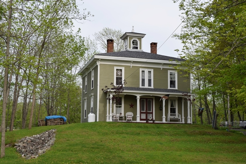
[Main Street] This handsome Italianate structure stands alone In the town of Mattawamkeag as the only residence of any serious architectural merit, a local landmark. The Smith House has remained virtually unchanged as have its ell and barn. Although not a rare or distinctly outstanding example of its style in the state, its presence, because of its size and elegance, is strongly felt as a contrasting element in a small community.
")
Asa Smith, was one of the first settlers in this community on the east bank of the Penobscot River. He served as a State Senator from Penobscot County. A successful merchant, he built a large combination store and home (now gone) on the main street. His son George built the present house in 1874 and carried on his father’s business. He served as postmaster for most of his adult life and became the local “sage” in his later years. Unaltered, the George W. Smith house is an outstanding residence, with its two internal brick chimneys, field-stone foundation, cupola and large 1 ½ story barn.*