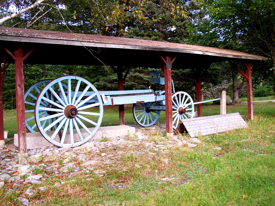
The “Galmander,” a granite lifter and hauler in the Franklin Memorial Park (2004)

Location Map for Franklin
| Year | Population |
|---|---|
| 1970 | 708 |
| 1980 | 979 |
| 1990 | 1,141 |
| 2000 | 1,370 |
| 2010 | 1,483 |
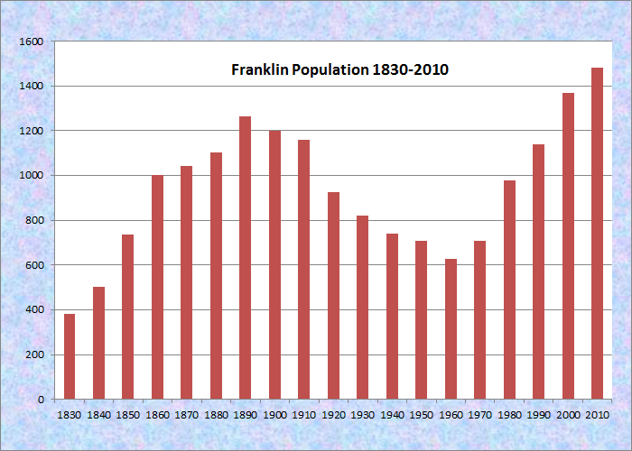
Population Trend 1830-2010
| Geographic Data | |
|---|---|
| N. Latitude | 44:36:10 |
| W. Longitude | 68:14:01 |
| Maine House | District 137 |
| Maine Senate | District 7 |
| Congress | District 2 |
| Area sq. mi. | (total) 41.7 |
| Area sq. mi. | (land) 36.7 |
| Population/sq.mi. | (land) 39.3 |
County: Hancock
Total=land+water; Land=land only |
|
")
Franklin Public Library (2004)
")
Franklin United Methodist Church
[FRANK-lin] is a town in Hancock County, incorporated on January 24, 1825 from portions of plantations number 8 and 9, MD.
Between 1837 and 1857 it annexed land from the balance of Plantation Number 9, from Hancock, and from Plantation Number 10.
The town has villages of Franklin, East and West Franklin, and, yes, Egypt on Egypt Bay.
Blueberries and Christmas trees are major crops in this still growing rural community. Images immediately below are in northwest Franklin near Eastbrook.
 N44° 38' 46.98\" W68° 15' 39.72\"")
Sunnyside Cemetery on Route 200 (2013) @
 N44° 38' 47.65\" W68° 15' 42.55\"")
Rock Strewn Blueberry Barrens (2013) @
Moses Butler was the first settler in 1764 at Butler’s point, a site of an earlier indian settlement
In addition to shipbuilding, the quarrying and shipment of white granite dominated the local economy for a century beginning in about 1840.
")
Volunteer Fire Dept. (2004)
Named for Benjamin Franklin, the town lies east of Ellsworth at the junction of Maine Routes 182 and 200.
Though substantially inland, the extension of Sullivan Harbor expands to Taunton Bay and Hog Bay to give it a coastal flavor.
")
East Franklin Village (2004)
")
Taunton Bay, West Franklin, Schoodic Mountain (2004)
The Taunton Bay Islands nature preserve consists of two small islands offshore of a large mainland bald eagle site purchased by the Nature Conservancy in 1989, helping to protect the eagle territory as well as the habitat used by thousands of migratory shorebirds.
")
Baptist Church (2004)
Additional resources
Carter, Bruce. Oblivion & Dead Relatives Downeast. 1996. Downeast Graphics and Printing.
Franklin Sesquicentennial: 1825-1975. 1975? [University of Maine, Raymond H. Fogler Library, Special Collections]
*Maine. Historic Preservation Commission. Augusta, Me. Text and photo from National Register of Historic Places: http://pdfhost.focus.nps.gov/docs/nrhp/text/92001292.PDF, http://pdfhost.focus.nps.gov/docs/nrhp/photos/92001292.PDF
Obermann, Henry B. Franklin, Maine: A History. c1975. Rockland, Me. Maine Coast Printers.
National Register of Historic Places – Listings
Robertson Quarry Galamander
Maine Route 182 East side, Northeast of junction with Old Road, West Franklin. This vehicle, whose name means “granite lifter,” was used in local quarries for nearly 100 years. It could lift several tons and transport them over the rough roads.
The Robertson Quarry Galamander is a four-wheeled, horse or oxen drawn wooden vehicle approximately 18 feet long and 6 feet wide. It is in a public park at the junction of Route 182 and the Old Road under an open, roofed shelter. Granite quarrying in the Town of Franklin is thought to have begun in the mid-19th century. However, large-scale operations do not seem to have developed until the late 1870s.
One of two intact examples known to survive in Maine, the Robertson Galamander is a specialized granite hauling vehicle once common in Maine’s quarries during the late 19th and early 20th centuries. A strong tradition indicates the vehicle originated on Vinalhaven, where an extensive granite industry existed. Galamanders could vary in size but they are a specific type of hauling vehicle, distinct from ordinary wagons or stone carts. Their derricks or levers, when combined with a block and tackle, could lift large pieces of stone and transport them, underslung, between the wheels.
The other Galamander is in Vinalhaven. However, it is a late 1960s replica of a vehicle which was felt to be too deteriorated to repair in whole or part.*
")
Robertson Quarry Galamander (2004)
")
Sign: Franklin Memorial Park (2004)
")
Revolutionary War Memorial (2004)

Galamander Pulled by Oxen