Mayall, Samuel

(1816-1892) a U.S. Representative, was born in North Gray on June 21, 1816. He attended the public schools and was tutored privately at home, later moving to Gray. A member of the Maine House of Representatives in 1845, 1847, and 1848, Mayall served in the Maine State Senate in 1847 and 1848. He declined the…
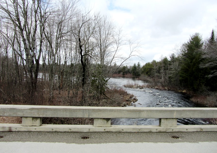
Maxim, Hiram Stevens

(1840-1916) was born in Sangerville February 5, 1840 and was famous for inventing the machine gun, ironically a “sanguinary” (bloody) instrument of warfare. Among other things, he invented smokeless powder for guns, a gas generator, a gas headlight for locomotives, automatic steam and vacuum pumps, and engine governors. According to Maine: A Guide Downeast, In…

Maxfield

Maxfield is definitely “off the beaten path” in northeastern Penobscot County. No main route passes through it and the town is split by the Piscataquis River with no bridge spanning it within the town. A bridge in nearby Howland crosses the river just before it empties into the Penobscot.

Mattawamkeag

Upper Gordon Falls on the Mattawamkeag River (2016) [See video]

The Mattawamkeag River, on which the town is located, is the largest eastern tributary of the Penobscot. See photos. The junction of the two rivers is marked by a gravel bar at the entrance to the Mattawamkeag. Thoreau, on his way to climbing Mount Katahdin, visited the area in 1847. Today, a 1,000 acre Wilderness Park is situated between the two rivers with campsites, fishing, swimming and hiking available.

Masardis

Railroad Crossing in Masardis near Fraser Timber Mill on Route 11 (2015)

The Aroostook River flows northward through the middle of the township and by the village of Masardis. The small Pollard Flat Wildlife Management Area lies on the west bank of the river north of the village. A boat launch provides access to Scopan (formerly Squa Pan) Lake. Most of the Lake is in adjoining Scopan Township.

Blaine

Blaine Village on U.S. Route 1 (2016)

named for Maine politician James G. Blaine, it is a “half-township” town, forming a rectangle only half the size of the typical 6-mile by 6-mile square township. In the heart of potato country, between Bridgewater and Mars Hill on Route 1, the town’s eastern boundary is shared with Canada.

Marshfield

Location Map for Marshfield

The main village lies just north of Machias on Maine Route 192 and on the Middle River, which empties into the Machias River. The captured British schooner Margaretta was hidden by being hauled out of sight up the Middle River. Marshfield is dotted with small lakes and the marshes that reflect its name.

Mars Hill

Mars Hill mountain with Wind Turbines from U.S. Route 1 in Blaine (2014)

As with many rural Maine towns, Mars Hill is a community of pickup trucks as an essential tool of the farm economy. See photos. It shares a main street, U.S. Route 1, with neighboring Blaine. Mars Hill is located on the Prestile Stream where U.S. Route 1 forks to Presque Isle and Route 1A leads to Fort Fairfield. Established in the 1960’s, the Big Rock Ski Area on Mars Hill was purchased in 2000 by the Maine Winter Sports Center.

Mason, Moses, Jr.

Dr. Moses Mason (1789-1866) [Erroneously named “Moses Mason, Jr.]  was  born in Dublin, New Hampshire on June 2, 1789. He moved with his parents to Bethel in 1799, attended the common schools. He studied medicine, and began his practicend practice in Bethel in 1813. Mason was appointed first postmaster of Bethel on April 1, 1815,…

Marshall, Alfred

Alfred Marshall (ca. 1797-1868) a U.S. Representative, was born in New Hampshire about 1797. A member of the Maine House of Representatives in 1827, 1828, 1834, and 1835, he served as a general in the Maine State militia. Marshall was elected as a Democrat to the Twenty-seventh Congress (March 4, 1841-March 3, 1843), later serving…

Mariaville

Union River East Branch from Jones Bridge Between Waltham and Mariaville on Route 179 (2013)

The town, with substantial frontage on Graham Lake and the east and west branches of the Union River, was named for William Bingham’s daughter Maria. With over 17% of its area covered with water, it is one of the most water-covered non-coastal towns in the state. While somewhat remote twelve miles north of Ellsworth, the town has a small but consistently growing population.

Margaretta

Map: 1785 Survey of Machias Bay

On May 9, 1775, Captain James Moore sailed the British warship, the Margaretta, into Machias harbor with news of the battles of Lexington and Concord. The vessel had traveled to Maine to insure that a load of lumber was delivered for the British army’s barracks in Boston. In response the people of Machias erected a…

Mapleton

Autumn Fields and Hills in Mapleton from Route 163 (2014)

is a town in Aroostook County, incorporated in 1880 from Mapleton Plantation. The early settlers, arriving in about 1836, were from New Brunswick. Potatoes have been a major part of its economy in the 19th and 20th centuries. The Aroostook War of the 1840s discouraged settlement until the 1850s.

Manchester

Still a basically rural community, Manchester has maintained its old 1793 North Manchester Meetinghouse. It also features a sustainable forestry project within a few hundred yards of the Meetinghouse on Scribner Hill Road. A suburb of Augusta, the town has substantial frontage on the northern half Cobbosseecontee Lake.

Mammals

Maine’s Department of Inland Fisheries and Wildlife has developed a summary table describing well-known mammals that make their home in the state.  To expand  that effective presentation, we have added some creatures to the table. Features Size Habitat Food Litter When Behavior BEAVER Largest rodent, flat scaly tail, large front teeth; sexes indistinguishable L 35-46″…

Rabbits

Map: Cottontail Rabbit and Snowshoe Hare Habitat

The New England cottontail rabbit was, in 2011, a candidate for federal listing as a threatened species. Less than 300 rabbits are believed to be in Maine, most in the south.  Threats include the loss of young forest and thickets due to the loss of agricultural land, pets such as cats, and invasive vegetation not…

Lobster Township

                                        Lobster Lake in Lobster Township is east of the northernmost portion of Moosehead Lake and of adjoining Northeast Carry Township.             Lobster lake, so-named because of its shape, dominates as…

Dresden Bog

The waterway broadens from the bog to the open water (2010)

The Erle R. Kelley Wildlife Management Area encompasses most of Dresden Bog, within the town of Dresden, and much of the adjoining land, some of which is in Alna. The Bog, one of Maine’s many nature preserves, is accessible from the south side of Bog Road in Dresden, where a nondescript, very narrow stream leads…

Beavers

Beaver Dam at Dresden Bog (2010)

are the largest of rodents. They have flat, scaly tails, and large front teeth. Beavers use their teeth to cut down and dismember small trees to use in construction projects: their homes (lodges) and dams to surround their lodges with water.  Access to the lodges is underwater, so most bothersome animals cannot get in. They…