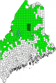
[PREN-tiss] is an unorganized township in Somerset County, not to be confused with Prentiss Township T7 R3 NBPP in Penobscot County.
As a result of the Maine Indian Lands Claim Settlement Act of 1980, the township is now Passamaquoddy Indian Territory.
With few improved roads, access is from U.S. Route 201 in Sandy Bay Township from the Old Kelly Dam Road, which runs along the southern portion of Prentiss.
The township contains several ponds surveyed by the Maine Department of Inland Fisheries and Wildlife years ago. Brief excerpts (edited and condensed) may be of interest:
Dubois Pond is an 18-acre shallow trout pond located northwest of the town of Jackman in Prentiss (T4 R4 NBKP) township. Except for a few rocky ledges, the shoreline of this remote pond is wet and vegetated with shrubs. The treeline is dominated by cedar, spruce, and white pine. The bottom of the pond is covered with several feet of organic debris. Access to Dubois Pond is by foot or ATV on a deteriorated logging road and a trail.1
Duncan Pond is a deep, cold 143-acre body of water located near the Canadian border. The Pond may be reached by travelling approximately 11 miles by jeep from U.S. Route 201. Unfortunately salmon and smelts were introduced many years ago. Salmon require a large body of water with suitable streams to maintain a thriving population. Trout populations decrease as the number of species increases in a pond. Now we have a potentially excellent trout pond that produces a few salmon, a few trout, and thousands of smelts, suckers, and chubs.2
Hall Pond is a 40-acre trout pond whose outlet flows into Duncan Pond, then into the South Branch of the Penobscot River. Fishermen should leave U.S. 201 about 4 miles south of the Canadian border, follow the Kelley Dam Road along the South Branch of the Penobscot River, and take the branch leading to Duncan Pond. A 4- wheel-drive vehicle becomes necessary if you plan to ride beyond Duncan Pond. An old road follows the tributary from Hall Pond and brings you within a 10-minute walk of the pond. The pond has an excellent brook trout population that exhibits a good rate of growth.3
Mary Petuche Pond is a 10-acre trout pond forming the headwaters of a chain of ponds which flow into the South Branch of the Penobscot River. It has nearly equal water temperatures at all depths, with a high oxygen content present throughout. The pond has no inlets. The outlet is obstructed by a series of beaver dams, but the uppermost dam is holding a useful 3-foot head of water. Bog vegetation surrounds much of the pond.4
– – – –
1 Maine. Department of Inland Fisheries and Wildlife. “Dubois Pond, T4R4 NBKP, Somerset County.” Surveyed – August, 1989. http://www.maine.gov/ifw/fishing/lakesurvey_maps/somerset/dubois_pond.pdf (accessed April 2, 2014)
1 Maine. Department of Inland Fisheries and Wildlife. “Duncan Pond, T4R4 NBKP, Somerset County.” Surveyed – August, 1961. http://www.maine.gov/ifw/fishing/lakesurvey_maps/somerset/duncan_pond.pdf (accessed April 2, 2014)
1 Maine. Department of Inland Fisheries and Wildlife. “Hall Pond, T4R4 NBKP, Somerset County.” Surveyed – July, 1989. http://www.maine.gov/ifw/fishing/lakesurvey_maps/somerset/hall_pond.pdf (accessed April 2, 2014)
1 Maine. Department of Inland Fisheries and Wildlife. “Mary Petuche Pond, T4R4 NBKP, Somerset County.” Surveyed – August, 1964. http://www.maine.gov/ifw/fishing/lakesurvey_maps/somerset/mary_petuche_pond.pdf (accessed April 2, 2014)
Additional sources
Chadbourne, Ava Harriet. Maine Place Names and The Peopling of its Towns.


