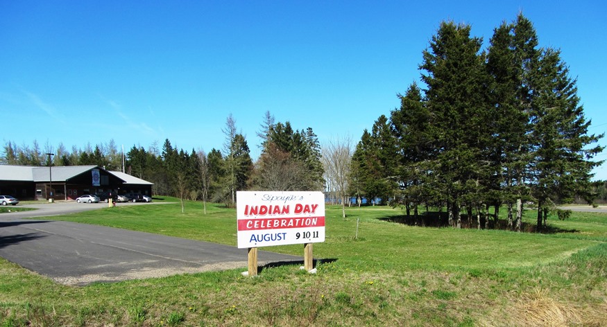
Passamaquoddy Tribal Office in Perry promoting Indian Day (2013)

Location Map for Perry
| Year | Population |
|---|---|
| 1970 | 878 |
| 1980 | 737 |
| 1990 | 758 |
| 2000 | 847 |
| 2010 | 889 |
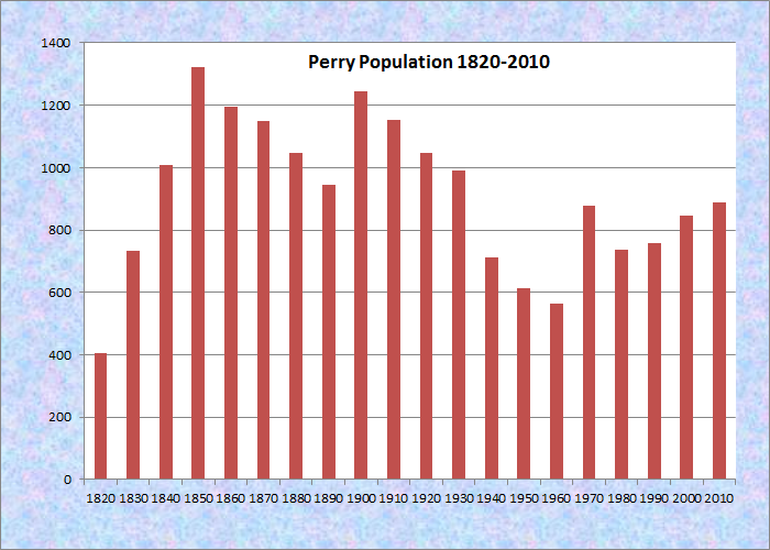
Population Trend 1820-2010
| Geographic Data | |
|---|---|
| N. Latitude | 44:55:00 |
| W. Longitude | 67:03:00 |
| Maine House | District 140 |
| Maine Senate | District 6 |
| Congress | District 2 |
| Area sq. mi. | (total) 42.6 |
| Area sq. mi. | (land) 29.5 |
| Population/sq.mi. | (land) 30.1 |
County: Washington
Total=land+water; Land=land only |
|
")
[PEH-ree] is a town in Washington County. In 1800 a plantation form of government (Plantation No. 2) was established in the area currently in the towns of Dennysville and Pembroke. The first European settler, John Frost, established a trading post on the St. Croix River, the town’s eastern boundary along with substantial frontage on Passamaquoddy Bay. Perry was incorporated as a town on February 12, 1818 from Plantation T1 TS.
Named for Commodore Oliver H. Perry, a naval hero of the War of 1812, the town was incorporated as the British still held Eastport only six miles away. (They remained until June 1818.)
According to its 2009 Comprehensive Plan,
The first meeting in Perry was held in 1812 when a few sturdy pioneers met to devise ways and means to defend their property from smugglers and other lawbreakers. Because of its location, Perry offered a depot for storing smuggled goods from Grand Manan, which was British land, and afforded an excellent opportunity for carrying on illicit trade across international waters. [B-2]
The 19th century economy was supported by shipbuilding and later by the sardine industry. In 2009, the top three employment sectors, in order were “Education, health and social services,” “Manufacturing,” and “Agriculture, forestry, and fisheries, mining.”
")
Perry Elementary School (’13)
")
Farmers Union General Store
Perry is the gateway, via Maine Route 190, to the Pleasant Point Passamaquoddy Indian Reservation located withing the town, and to the City of Eastport.
Boyden Lake dominates the northwest portion of the town, while the southwest has miles of protected coves approaching Cobscook Bay.
Form of Government: Town Meeting-Select Board.
Additional resources [click on images to enlarge and clarify]
Lincoln, Dale C. Clyde Found Fruitflies in the Berries. Calais, Me. Calais Press, Inc. 1999. [University of Maine, Raymond H. Fogler Library, Special Collections; University of Maine at Machias, Merrill Library]
Lincoln, Dale C. There Were Fruit Flies in the Berries (but I ate them anyway). Gardiner, ME. Steele Publishing. c1991. [University of Maine, Raymond H. Fogler Library, Special Collections; University of Maine at Machias, Merrill Library]
Perry. THE TOWN OF PERRY, 2009 COMPREHENSIVE PLAN. http://www.maine.gov/spo/landuse/compplans/plans/perry/PerryCompPlan2009.pdf [An outstanding source of historical, demographic, and economic information.]
Sesquicentennial 1818-1968: Historical Souvenir Book Perry, Maine. Maine? 1968?