
Location Map for Northport
| Year | Population |
|---|---|
| 1970 | 744 |
| 1980 | 958 |
| 1990 | 1,201 |
| 2000 | 1,331 |
| 2010 | 1,520 |
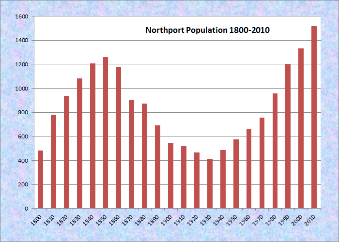
Population Trend 1790-2010
| Geographic Data | |
|---|---|
| N. Latitude | 44:21:20 |
| W. Longitude | 68:59:27 |
| Maine House | District 97 |
| Maine Senate | District 11 |
| Congress | District 2 |
| Area sq. mi. | (total) 34.4 |
| Area sq. mi. | (land) 23.7 |
| Population/sq.mi. | (land) 64.1 |
County: Waldo
Total=land+water; Land=land only |
|
")
Sign: Northport 1786 Welcomes You (2002)
[NORTH-port] is a town in Waldo County, settled in 1780 and incorporated on February 13, 1796 from Ducktrap Plantation, though “Ducktrap Harbor,” which it shares with Lincolnville, retains the original name.
 N44° 20' 54.7\" W68° 58' 9.0\"")
Northport Music Theater (’12) @
The modest Northport Music Theater, according to its web site, “features contemporary American musical theater and presents some of the best professional talent Maine has to offer.” in its livetheater productions. It has operated a “summer theater day camp” as well.
In addition to its long coastline facing Islesboro on Penobscot Bay, the town has frontage on the three-mile long Pitcher Pond and all of its Knight Pond.
St. Clair Preserve in Northport protects nearly all of unspoiled Knight’s Pond. The sanctuary, 304 acres of mixed forest, bogs, swamps and fields has been home to black bears, bobcats, fishers, foxes, and deer.
Loons and raptors are also common. Ducktrap Mountain rises over 700 feet from the pond’s edge. It is accessible by canoe and trails from the town landing on Knight’s Pond Road.
")
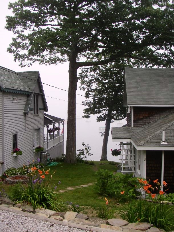
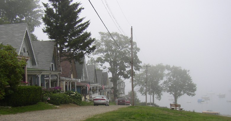
Entering Bayside Village
The historic Bayside village, a community primarily of closely space summer cottages, lies off U.S. Route 1 near East Northport, just south of Belfast.
The Northport Wesleyan Grove Camp Meeting Association, in Northport, Maine, was incorporated in 1873. The Association was part of the East Maine Conference of the Methodist Episcopal Church. The Northport Campground later became known as the village of Bayside, which is now a community of about three hundred cottages, most built between 1870 and 1900. (Cataloger Note from If These Cottages Could Talk . . . .)

Sidewheel Steamer Lewiston at Northport Landing (Undated photo posted at Fort Point State Park in July 2007)
 N44° 20' 12.2\" W68° 57' 48.2\"")
Town Office and Fire Station (2012) @
Form of Government: Town Meeting-Select Board-Administrator.
Additional resources
If These Cottages Could Talk: A History of Bayside in Northport, Maine. Belfast, Me. Bayside Historical Preservation Society. c2008. [Bangor Public Library]
**Maine. Historic Preservation Commission. Augusta, Me. Text and photos from National Register of Historic Places: http://pdfhost.focus.nps.gov/docs/nrhp/text/83003684PDF and http://pdfhost.focus.nps.gov/docs/nrhp/photos/83003684.PDF
Reed, G. H. Bayside, Maine: A Thumbnail History. Rockland, Me. Courier-Gazette Press. 1947. [University of Maine, Raymond H. Fogler Library, Special Collections; Bangor Public Library]
Special Number of the Northport Budget: Containing the History and Census of the Town. Northport, Me. The Northport Budget. 1908. [Maine State Library]
*United States. Department of the Interior. National Park Service. “Bayside Historic District.” https://maineanencyclopedia.com/wp-admin/post.php?post=23228&action=edit (accessed March 4, 2017)
National Register of Historic Places – Listings
Bayside Historic District
[roughly bounded by Penobscot Bay, Clinton Avenue, George Street, and Bay View Park, Bayside] Bayside Historic District is comprised of a large group of small wooden cottages and several parks that originally constituted the Northport Wesleyan Grove Camp Meeting grounds. It was acquired during the second quarter of the 19th century for Methodist camp meetings in which participants occupied tents. The property was enlarged and more permanently developed after the Civil War with the construction of roads, parks, and cottages. By the early 20th century it had acquired the name Bayside.
As Methodism gained popularity (its adherents grew in number from 2,800 in 1800 to over 1,068,525 in 1844, so too did the practice of the camp meeting, which was regarded as a useful forum for making new converts while renewing the faith of others and offering an opportunity for further spiritual development. One historian of Maine Methodism credits the camp meeting as one of the three most important factors to the denomination’s growth in the state, citing about forty places where camp meetings are known to have taken place.
On September 14, 1848, several individuals purchased a twenty-eight acre parcel on Penobscot Bay. Two years later, this group transferred the property to the trustees of the Northport Camp Ground Association; an organization comprised of twenty-three Methodist churches in Knox and Waldo counties, as well as the Circuits and Stations of the Methodist Episcopal Church. This parcel, which constitutes the core of the present historic district, was apparently chosen for both its picturesque setting and its central location.
Cottages at Bayside Village (2003)
In the late 19th century the informal tent community began to evolve into a series of permanent cottages, streets, wells, privies, and a complete sewsage system. In retrospect, these many improvements and permanent additions to the grounds can probably be seen as the beginning of the end of Northport’s religious camp meeting, as the pattern of use and development was increasingly centered around things secular rather than spiritual.
The decades of the 1920s and 1930s witnessed a continual decline and finally the termination of the religious aspect of Bayside. Annual camp meetings were held through 1930 (and again in 1932), along with Sunday services in July and August. However, at their 1935 annual meeting, the members of the Association voted to demolish the auditorium, and within two or three years the organization apparently was dissolved and its assets turned over to the Preacher’s Aid Society of the Maine Conference of the Methodist Episcopal Church. Title to the Association’s remaining real estate (principally Auditorium Park) was subsequently transferred to the secular Village Corporation.*
In 2017 Bayside retains its attraction as a summer colony with a considerable number of the cottages still available for rent.
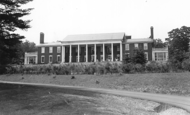
Cobe Estate
[North of Northport on Bluff Road] This mansion overlooking Penobscot Bay is by far the largest and most lavish Colonial Revival summer residence in Maine and certainly rivals any similar house in that style on the east coast. Beyond this, the quality of the interior decorative features is remarkably high and in unusually fine taste.
")
The house was designed by Marshall & Fox, one of Chicago’s leading firms, for Ira Maurice Cobe (1866-1931), a lawyer who founded the highly successful investment firm of Cobe & McKinnon, also of Chicago. Originally from Boston, Cobe had married Anne Watts of Belfast and chose Northport as a location for their summer house so she could be near her family and friends during that season.**
Hi,
Hoping to find someone who can help me identify the remains of a mill/dam site observed while walking on the Duck Trap river Trail, south of Rte. 52. Seems to have been a saw mill or grist mill (so far as I can tell from looking at old maps); on old maps ,it looks like it’s on Duck Trap River, but newer gazetteer calls the water Kimball Stream. Any ideas?
Thanks for any help!
Jennifer Kiernan