")
Pineland Farms near the Intervale Road in New Gloucester (2013)

Location Map for New Gloucester
| Year | Population |
|---|---|
| 1970 | 2,811 |
| 1980 | 3,180 |
| 1990 | 3,916 |
| 2000 | 4,803 |
| 2010 | 5,542 |
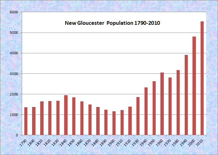
Population Trend 1790-2010
| Geographic Data | |
|---|---|
| N. Latitude | 43:57:26 |
| W. Longitude | 70:17:43 |
| Maine House | District 65 |
| Maine Senate | District 20 |
| Congress | District 1 |
| Area sq. mi. | (total) 47.8 |
| Area sq. mi. | (land) 47.1 |
| Population/sqmi | (land) 117.7 |
| County: Cumberland Total=land+water |
|
 N43° 59' 20.6\" W70° 17' 34.8\"")
Veterans Memorial (2012) @
") [NEW GLOSS-ter] is a town in Cumberland County, incorporated on March 8, 1774 from New Gloucester Plantation.
[NEW GLOSS-ter] is a town in Cumberland County, incorporated on March 8, 1774 from New Gloucester Plantation.
Settled in 1738, the inhabitants abandoned the town during the French and Indian Wars (1741-1751) but returned to the rich farmland to reestablish the town. A plaque on the grindstone near the town office notes that the stone is from “the first grist mill erected by the pioneers of New Gloucester on Stevens Brook” in 1758.
")
New Gloucester Town Office
")
New Gloucester Meetinghouse
")
New Gloucester Public Library
")
Mill Stone from Intown Mill
Images above are adjacent to the town office in the Historic District (2012)
at N43° 57′ 50.09″ W70° 16′ 55.39″
Samuel Clement Fessenden (1815-1882), brother of Thomas Amory Deblois Fessenden and William Pitt Fessenden, was born in New Gloucester on March 7, 1815. He was elected as a Republican to the Thirty-seventh Congress (March 4, 1861-March 3, 1863). U.S. Representative Ezekiel Whitman practiced law here.
 N43° 59' 0.56\" W70° 17' 24.64\"")
Memorial Elementary School (2012) @
 N43° 59' 20.98\" W70° 17' 36.44\"")
Masonic Building (2012) @
 N43° 53' 42.84\" W70° 15' 18.06\"")
Pineland Farms Barns (’13) @
 N43° 53' 41.82\" W70° 15' 17.76\"")
Equestrian Center (2013) @
The longtime home for Pineland Center from 1908 to 1996, that State facility for the mentally retarded was once known as the “Maine School for the Feeble-Minded” and later as the Pownal State School. (The village of West Pownal is nearby.)
It was the place to which many residents of Malaga Island were sent after their community was forcibly disbanded by the State of Maine.
After the closure of Pineland Center, the State sold the facility, which has been redeveloped as an office park. Pineland Farms and its Equestrian Center are major facilities near Pineland Center. The multiple use Pineland campus hosts professional, educational, and civic organizations, along with its conference facility.
 N43° 53' 43.92\" W70° 15' 18.70\"")
Pineland Center (2013) @
 N43° 54' 4.15\" W70° 15' 15.27\"")
Entrance to Pineland (2013) @
 N43° 54' 4.97\" W70° 15' 16.73\"")
Typical Building (2013) @
Moses Greenleaf, Maine’s early mapmaker, lived here as a young man, before moving to what is now Williamsburg Township in Piscataquis County.
In 1783 the United Society of True Believers, the “Shakers” made their home at Sabbath Day Lake Village, or Shaker Village, near the town line with Poland on Maine Route 26. The 1700 acre community has all but died out, though its buildings and a library with documents and audio tapes survive. Other Shaker communities were established at the same time in Alfred and Gorham, but no longer exist.
")
Shakers Cemetery Monument
")
Buildings at Shaker Village (2003)
Sister Frances Carr wrote of her experiences as a Shaker in Maine with her detailed account of life in the religious community, and her colorful anecdotes about some of the better known Shaker leaders.
")
Dwelling House at Shaker Village (2003)
")
1882 Shaker Library (2003)
")
Sabbath Day Lake (2003)
 N43° 58' 2.60\" W70° 17' 3.49\"")
House/Barn near Town Hall in Historic District (2013) @
New Gloucester’s villages and rural areas have many examples of substantial older homes, farms, and other classic structures.
The town hosts the 30-acre Intervale Nature Preserve, and a portion of the Pineland Public Reserved Land of more than 600 acres of land on both sides of Route 231 in New Gloucester, Gray and North Yarmouth.
(See Cumberland County Nature Preserves.)
 N43° 54' 5.05\" W70° 15' 32.75\"")
Burchard Dunn School (’13) @
 N43° 59' 1.37\" W70° 17' 26.32\"")
Memorial School (2013) @
 N43° 57' 43.38\" W70° 18' 4.13\"")
Fire and Rescue (2013) @
Form of Government: Town Meeting-Select Board-Manager.
Additional resources
The Bicentennial of New Gloucester: Being an Account of the Celebration of the Two Hundredth Anniversary of the Coming of the First Settlers. New Gloucester, Me. New Gloucester, Maine, Historical Society. 1945.
Brooks, Leonard L. “Sabbath Day Lake Shaker Village Opens Nature Walks.” Maine Archives and Museums Newsletter. August, 2003. p. 13.
Chandler Family. Family Papers 1750-1956. (Cataloger Note: The Chandler family papers consist of business and personal papers of several generations of the family as well as materials concerning the town of New Gloucester, Maine. They reflect the involvement of the family in farming, a general store and grocery, and the lumber industry. . . . The New Gloucester series contains various documents from citizens of the town as well as a small group of materials about the militia, schools, churches, and various organizations in the town.) [University of Maine, Raymond H. Fogler Library, Special Collections]
Haskell, Thomas Hawes. The New Gloucester Centennial, September 7, 1874. Portland, Me. Hoyt, Fogg & Donham. 1875.
Maine. Historic Preservation Commission. Augusta, Me. Text and photos from National Register of Historic Places: http://pdfhost.focus.nps.gov/docs/nrhp/text/xxxxxxxx.PDF and http://pdfhost.focus.nps.gov/docs/nrhp/photos/xxxxxxxx.PDF
Intervale Farm: 03001407.PDF
New Gloucester Historic District: 74000162.PDF
Shaker Village: 74000318.PDF
Universalist Meeting House: 88000887.PDF
Management Planning for Pineland Public Lands, Bradbury Mt. State Park, and the Bureau of Parks and Lands’ Properties Linking Each. Maine. Department of Conservation. http://www.maine.gov/doc/parks/programs/planning/pinebrad/index.html (accessed January 31, 2012)
“National Register Nominations.” Maine Preservation. Spring 2004. p. 8.
New Gloucester Bi-Centennial, 1774-1974. 1974? [University of Maine, Raymond H. Fogler Library, Special Collections]
New Gloucester Creamery Butter Company. Records, 1883-1888. (Cataloger Note: The records of a creamery in New Gloucester, Maine. Included are the certificate of organization, articles of agreement, by-laws, deeds, insurance policies (1884, 1885 and 1887), and bills and receipts.)
National Register of Historic Places
Intervale Farm
 N43° 55' 42.41\" W70° 14' 56.78\"")
Intervale Farm on Intervale Road (2013) @
[1047 Intervale Road] The Intervale Farm in the Fogg’s Corner area embodies both an initial architectural style and building material relatively unique to this section of town. It is the only two-story brick structure built in New Gloucester prior to 1824. An evolution of spatial adaption that reflects almost two centuries of agricultural functions, the farm is comprised of a long complex of buildings, fields, gardens and pastures, stone walls, tree lines and orchard remnants. Set in an historically successful agricultural community, the Farm is one of six properties in the Fogg’s Corner settlement that retain their agricultural roots.
The first recorded deed that identifies the structure is dated to 1838 and reflects the sale of Ammi R. M. Cushman’s brick farmstead to Micajah Plummer. Jabez Cushman, an early owner, was a wealthy man: in 1788 he was one of the proprietors of Buckstown (Buckfield) although he lived in New Gloucester. He served as a selectman in New Gloucester in 1808 and served in the local militia as a captain, and also held the job of warning off illegal settlers in Buckstown in 1789. Although it is not known for certain if he built the Intervale Farm house, it is a structure that certainly would have been appropriate for a man of his social and economic stature. The estimated date of construction is 1811. Because the structure faces the road, it is probable that it was built after the road was laid in the first decade of the 19th century. In 1824, one of New Gloucester’s founders, Isaac Parsons, reported on the town’s first fifty years. In his comments, he identifies only two brick houses in town, out of 240 structures, this being one.
") Intervale Farm remains under cultivation today, and as the acres of pumpkins and flowers planted by the current owners thrive their beaut continues to add to the dignity, significance, and history of the almost two hundred year old farmstead.
Intervale Farm remains under cultivation today, and as the acres of pumpkins and flowers planted by the current owners thrive their beaut continues to add to the dignity, significance, and history of the almost two hundred year old farmstead.
New Gloucester Historic District
[both sides of Maine Route 33 and Maine Route 231] New Gloucester was one of the few well-settled inland towns in Maine during the last half of the 18th century. The wealth of fine late 18th and early 19th century homes in the Historic District attest to its early prosperity as an agricultural community. Few villages in Maine have as many substantial two and a half story homes of the period in their original setting.
 N43° 58' 1.98\" W70° 17' 3.24\"")
Chandler House B&B @
The township of New Gloucester was granted in 1735 to sixty citizens of Gloucester, Massachusetts. The land was divided into sixty-three equal shares, of which the additional three were set aside for the first minister, the support of the ministry, and the schools. Families soon built log-houses and a saw mill. In the autumn of 1742, the household goods of the first settlers were landed at the mouth of the Royal River and poled up stream on rafts to the bridge that had been built in 1739.
A new war with France broke out in 1744; the community was abandoned because of the Indians.In 1753 some people returned and built a blockhouse to serve as their home, fort, and church. Slowly the community rebuilt. In 1756 a road was cut to North Yarmouth on the coast, and two years later the first grist mill was built. Isaac Parsons arrived in 1761 and built New Gloucester’s first frame house, a one and a half gambrel roofed dwelling. The first schoolmaster and the first minister came in 1764. A year later the Rev. Samuel Foxcroft’s grand two and a half story house became the first major frame structure in the town. The town was incorporated in 1774.
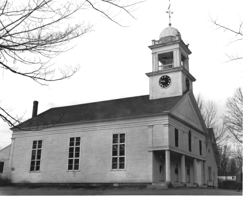
New Gloucester First Congregational Church and Vestry (1974)
With a good beginning before the Revolution, New Gloucester grew rapidly after the war. From the early 1790s until 1805 New Gloucester served as half-shire town with Portland for Cumberland County. This further helped to develop the community. Many houses now in the historic district were completed by the first decades of the 19th century. Since its founding in the mid-18th century, New Gloucester has been primarily a farming area. While some of the homes in the historic district have been purchased and restored by those employed outside of the community, many are still owned by those who continue to work the soil or are retired from it. For more than two hundred years, the farmland and the houses of New Gloucester have blended to become a distinctive and enduring statement of rural Maine.* [Richard D. Kelly photo (1974)]
Shaker Village, National Historic Landmark
[Maine Route 26 Sabbathday Lake and vicinity] The Society owned, in 1974, a tract of over 1,700 acres of forest, field and lake shores, unaltered since the community’s inception in 1793. The 17 buildings are in an excellent state of preservation. Though many Shaker villages have been preserved as commercial restorations, the community at Sabbathday Lake represents and interprets the best of Shakerism as a meaningful, on-going lifestyle.
The 1794 Meeting House is believed to have been designed by Moses Johnson. The Central Dwelling House was built in 1884. A 3 ½ story brick building with a full basement, it contains sleeping rooms, the chapel, a music room, a kitchen and dining facilities. An extensive archive used by about 250 scholars annually is preserved in the Library. The 1824 Laundry has rooms for sewing, weaving and tailoring. The Brethren’s Shop is filled with a complete wood-turning and smith’s shop.*
Universalist Meeting House
[Maine Route 231, south of Foggs Corner, Intervale] The 1839 Universalist Meeting House is a dignified rural example of the Greek Revival. Its modest but nevertheless striking composition is rarely matched by its related property sub-types.
 N43° 55' 24.96\" W70° 14' 53.88\"")
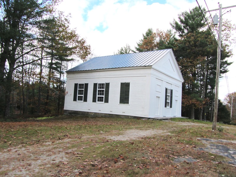
The First Universalist Society of Christians in New Gloucester was organized in 1805 with members drawn from nearby communities including Gray, Pejepscot and Poland. In 1830 it reorganized into the First Universalist Society of New Gloucester and Pownal. During its early history, services were apparently held at various places in the community. In 1838 a meeting was called to build a meeting house By September of the following year the church had been completed and the pews assigned to their owners. Church records suggest that the society was in a fairly constant state of financial crisis throughout much of the 19th century. About 1900 the congregation became reinvigorated. The founding of a Sunday School and Ladies’ Circle, as well as alterations to the main building indicate a renewed commitment to the Church while underscoring its role in the local community. After World War I membership began to decline and from the 1930s until the society’s demise in 1957 services were infrequently held. In 1969 the property was acquired by the New Gloucester Historical Society.*