
Location Map for Kennebunk
| Year | Population |
|---|---|
| 1970 | 5,646 |
| 1980 | 6,621 |
| 1990 | 8,004 |
| 2000 | 10,476 |
| 2010 | 10,798 |
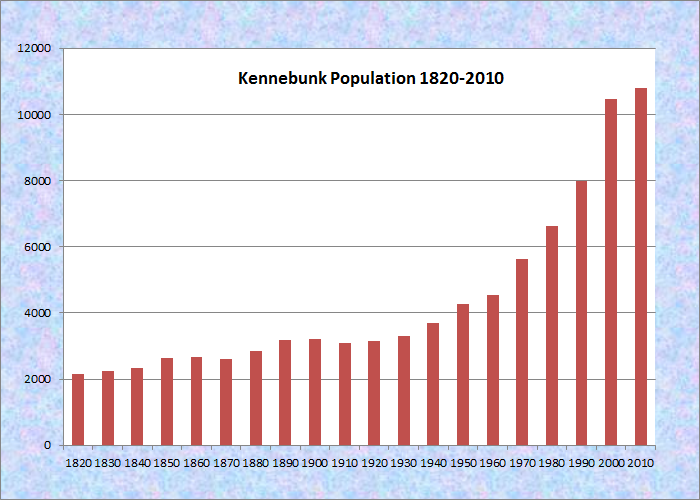
Population Trend 1820-2010
| Geographic Data | |
|---|---|
| N. Latitude | 43:24:01 |
| W. Longitude | 70:346:24 |
| Maine House | District 8 |
| Maine Senate | District 34 |
| Congress | District 1 |
| Area sq. mi. | (total) 35.5 |
| Area sq. mi. | (land) 35.19 |
| Population/sqmi | (land) 307.6 |
County: York
Total=land+water; Land=land only |
|
Clipper Ship Built Here
- Roebuck–1851
")
First Parish Unitarian Church in the Historic District (2002)
KEN-eh-bunk] is a town in York County, incorporated on July 31, 1820 from a portion of Wells that was first settled, though not permanently, in the 1640’s and 1650’s.
The name means “the long cut bank” for a land formation near the sea which may have served as a navigational aid to the Indians.
Sir Fernando Gorges designated the Kennebunk River as the dividing feature between the two parts of his province, which he received in his royal grant of 1639.
The First Parish Unitarian Church is one of a relatively small number of surviving Federal style religious buildings in Maine characterized by a central pavilion which projects from the main block, and a tower that either rises through or straddles both sections.
By 1717 the area between the Kennebunk and Mousam Rivers was known as Kennebunk.
The first permanent settlers arrived the following year.
Kennebunk Beach village is just across the mouth of the Mousam River from Kennebunkport.
")
Kennebunk High School (’12)
")
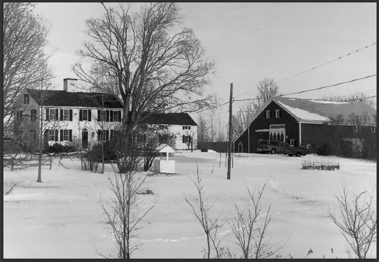
Buildings on Main Street (’12)
Shipbuilding and shipping were once staples of the local economy, which is now oriented to tourism and light manufacturing.
The conversion of historic buildings for contemporary use and the establishment of historic districts has enhance Kennebunk’s appearance and its attraction for visitors and new residents.
Permits for use of Gooch’s Beach, Kennebunk Beach (Middle Beach) and Mother’s Beach are issued by the town. Non-residents pay a premium.
The authors of Maine’s Historic Places observed:
The significance of this historic district lies in its architecture, for nothing remains of the great shipyards.
The homes of the shipbuilders, shipowners, and sea captains survive, however, leaving a largely unchanged picture of life in a sea-oriented village of earlier times.
")
Kennebunk Library in the Historic District (2002)
")
Water District offices in the Historic District (2002)
The birthplace of historical novelist Kenneth L. Roberts, the Storer House, was also the home of Revolutionary War General Joseph Storer who was host to General Lafayette when he toured America in 1825. Joseph Dane, Maine’s first U.S. Representative, made Kennebunk his home. Baseball great John Wesley “Colby Jack” Coombs made Kennebunk his home.
")
")
")
")
")
")
Many elegant, large older houses with a variety of styles grace the community.
The “Wedding Cake House,”
[ right above] known formally as the George W. Bourne House, claims to be the most photographed house in Maine. It is on the National Register of Historic Places.
Two nature preserves grace the town, both managed by The Nature Conservancy. Kennebunk Plains, a 1,000-acre sand plain community, provides vital habitat for the endangered grasshopper sparrow and four other animals and plants of special concern in Maine.
The Kennebunk River bisects the Butler/Marshall Preserves, which together span 195 acres and over a half-mile of river frontage. The area is predominantly pine forest. Picnic Rock, a large glacial boulder, is a popular spot for picnicking and swimming.
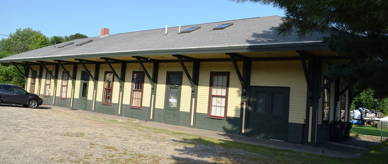
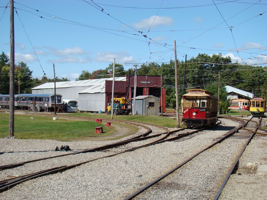
Former Railroad Station (2018)
Kennebunk has seen phenomenal growth in recent years, as has much of York County. For all its modern buildings, the old railroad station, now re-purposed, remains a symbol of the “good old days.”
Form of Government: Town Meeting-Select Board-Manager.
Additional resources
Beard, Frank A. and Bette A. Smith. Maine’s Historic Places: Properties on the National Register of Historic Places. Camden, Me. Down East Books. c1982, pp. 282-286.
Bourne, Edward Emerson. The History of Wells and Kennebunk From The Earliest Settlement To The Year 1820, . . . . Bowie, Md. Heritage Books, Inc. 1983.
Barry, William E. Chronicles of Kennebunk; being scenes and episodes in an old Maine village & vicinity. Illustrations by the writer, redrawn by Rockwell Kent. New York. Printed by Redfield-Kendrick-Odell Co. c1924.
Bourne, Edward Emerson. Kennebunk Folks. Kennebunk, Me. Brick Store Museum. 1967.
Bryant, S.E. A List of Vessels Built from 1800 to 1878 [with a supplement from 1874 to 1884]. Kennebunk, Me. Brick Store Museum. 1950.
Magnuson, Rosalind. Trunks, Textiles & Transits: Manufacturing on the Mousam River. Kennebunk, Me. Brick Store Museum. 2005.
*Maine. Historic Preservation Commission. Augusta, Me. National Register source files have changed! 2016 UPDATE: Follow the link above to find sources for these properties using their eight digit “Reference Number.“
Bourne Mansion: 80000381
Lord Mansion: 73000158
Lower Alewive Historic District: 94000178
Kennebunk High School: Maine Preservation. “Park Street School, Kennebunk.” http://mainepreservation.org/park-street-school
Kennebunk Historic District: 74000324
Smith, James, Homestead: 82001887
Wallingford Hall: 04000372
Remich, Daniel. History of Kennebunk from its Earliest Settlement to 1890: including biographical sketches. Salem, Mass. Higginson Book Co. 1992.
Schmidt, Henrietta. Down to the Seas. Kennebunk, Me. Star Press, Inc.. c1977.
Walker, Andrew. Military and Naval History of Residents of Kennebunk, Who Enlisted During The Late Civil War. Kennebunk, Me. 1868.
National Register of Historic Places – Listings
Bourne Mansion
[8 Bourne Street] Built In 1812 by John Usher Parsons, successful merchant and Massachusetts State Senator, the Bourne Mansion is arguably the finest dwelling Kennebunk and one of the most impressive examples of Federal architecture in southern Maine. The house was apparently based on the plan of a house in Newburyport occupied before her marriage by Mrs. Parsons.
The interior of the house matches the exterior in elegance with a wide hall passing the length of the structure front to back and joined in the center by a slightly narrower hall leading from the east entrance. Other features include an elaborately finished spiral staircase of three flights, an arch embellished niche for a tall clock, and an arched ceiling for the side hall. In 1815 the house was sold to Daniel Sewall, Clerk of Courts and Registrar of Deeds in York County. It was bequeathed in the latter part of the 19th century by Mrs. William Sewall to her nephew, Edward E. Bourne, Jr., member of an old Kennebunk family prominent over several generations as ship builders, historians, jurists and legislators.*
Hedden Site, Address Restricted
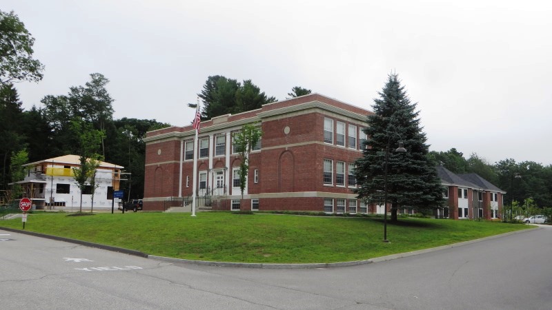
Kennebunk High School, former
 N43° 23' 7.48\" W70° 32' 8.18\"")
[14 Park Street] Park Street School, designed by the Boston architectural firm of Hutchins and French in the Colonial Revival style, was completed in 1922. It operated as a high school until 1939 and an elementary school until 2006, when it closed in 2006 and remained vacant. The property became overgrown and hardly visible from the street.
Avesta housing saw an opportunity to provide much needed affordable housing in the neighborhood. Their rehabilitation project focused on the retention of the significant brick building facing Park Street while recent rear additions were replaced with a compatible modern addition. The most significant interior spaces remain intact and recognizable to former students, while the classrooms have been made into apartments. All corridors were retained and the two-story gymnasium at the core of the building was used for community space.
Original wooden windows were retained on the prominent elevations and wooden pilasters were replicated. Trees planted too close to the building were removed and disease-resistant elms replanted along the street, as shown in historic photos.*
Kennebunk Historic District
[both sides of Maine Route 35 from Kennebunk River to US Route 1, radiating streets at intersection] The early history of Kennebunk is also that of the town of Wells, incorporated in 1653, and included within its boundaries the present town of Kennebunk. The area that came to be known as the town of Kennebunk in 1820 lies mainly between the Mousam and Kennebunk Rivers. The Historic District lies between these two rivers.
Up to the year 1700, little progress had been made in the settlement of the area now the town of Kennebunk. Between 1700 and 1750 however, the privileges and lands between the Mousam and Kennebunk Rivers were in great demand. On March 22, 1736, 100 acres of land was surveyed for Nathaniel and Richard Kimball. This survey inaugurated the permanent settlement of the village area. Up to that time, no house had been erected within its limits. There had been a few temporary structures that even by 1736 no longer existed. From the mid-18th century on, the area between the Mousam and Kennebunk Rivers grew into a large town with a history significant to Maine and the nation.
The village proper was between Portsmouth, N.H. and Portland on the Post Road. It was here on both sides of the Post Road where most of the local businesses grew and prospered. Further down the Kennebunk River was where many of the ships were built that plied the oceans of the world with Kennebunk men as Masters. The real significance of this Historic District is in its architecture, for nothing remains of the great shipyards. The homes of the shipbuilders and shipowners and captains do survive and within this survival we are left with a picture of what their life was and how they lived. The area within the District has not changed significantly since these great houses were built. Within this small area a great spectrum of all types of architecture from the mid-18th century colonial to the late 19th century Queen Anne still exists. All but one of these great houses were built of wood for it was the material most readily available. These homes were almost all built and designed by local men.* [See photos above.]
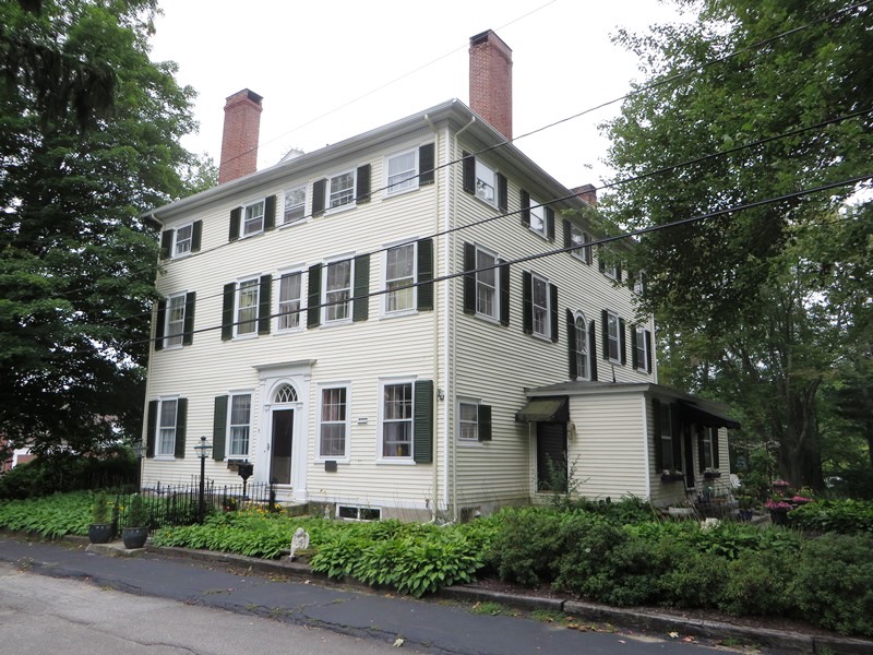
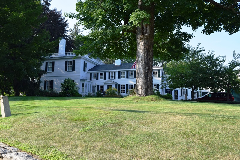
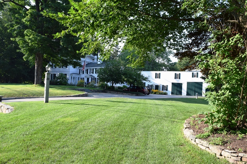
Lord Mansion
Lord Mansion in Kennebunk (2018)
Lord Mansion in Kennebunk (2018)
[20 Summer Street] The Lord Mansion combines the Colonial and Federal styles of architecture in one building. The original house, now the ell of the Lord Mansion, was built in clapboard style about 1760 by Jonathan Banks for Nathaniel Lord. Architecturally it is significant in that the building is excellent piece of colonial architecture, basically unaltered, and a fine piece of Federal architecture contained in one structure.
")
Lord Mansion (1972)
Judge Clark, second owner and the man who added the Federal section of the house, was the first Collector of Customs for Wells Township. (The area now Kennebunk was part of Wells until 1820.) The first Customs House in Wells, Judge Clark’s office, was on the driveway leading to the house. This house is also referred to as the Clark Mansion. In 1822 William Ford, shipbuilder and shipowner, bought the property and it remained in his family for over 150 years.*[R.D. Kelly, Jr. B&W photo]
Lower Alewive Historic District
[north side Emmons Road, East of junction with Maine Route 35] The Lower Alewive Historic District contains four farmsteads and over two hundred acres of farmland and woodlots representing the most intensive period of agricultural activity in Kennebunk from the late 18th to the early part of the 20th century. Four miles northwest of the village center, the District contains farms first settled in the 1750s. The District has a natural northern boundary in the Kennebunk River, and has been separated from Kennebunk Village on the east by the Maine Turnpike.
In the 1750s lots averaging 50 acres were sold on the south side of the Kennebunk River. Alewive, a name derived from the small fish of the same name, has traditionally been applied to the northwest corner of the township between the Kennebunk River and the Alewive Brook. With its close proximity to Kennebunk and the Maine Turnpike, the lower Alewive area has changed with the introduction of new housing on small lots. The large open land between the houses and the Kennebunk River distinguishes the properties in the District from the surrounding areas.
The men who first acquired the four farmsteads in the historic district–James Smith, Samuel Littlefield, Jr., Stephen Larrabee,and John Taylor–improved the land and erected buildings. Little evidence remains of these earliest structures.
The prosperity of the farms is evident in the large houses built by James Smith and John Walker in the early 1800s. Both are a full two stories with large rooms and Federal style woodwork, testimony to an ability to improve their properties. The earlier structures on the two Emmons farms were replaced or remodeled toward the middle of the 19th century. Portions of the earlier structures may have been used in enlarging the existing houses, suggesting that even in the 18th century the first farmsteads were relatively substantial.
")
Collins Emmons Farm (1993)
")
Walker-Russell Farm (1993)
In 1860 the farms of James Smith, Collins Emmons and John Walker all had 30-40 acres of improved cropland. The crops produced were corn, oats, peas and beans, potatoes, and hay. Dairy products, such as butter, were also important. Sheep were kept on three of the farms in 1850, but were gradually eliminated over the next two decades.
By the early 1800s both the upper and lower Alewive communities were sufficiently well defined to have had their own schools and churches. The close proximity to Kennebunk village, however, meant that the lower Alewive section had no separate commercial centers. Improvements in transportation further eroded a need for community services. By 1900 the local congregation had dissolved and the church building taken down.
The significance of the farms in the Lower Alewive Historic District is largely due to their shared history, use, and similarities in layout and plan. It is also due to the large quantity of open land between the houses and the Kennebunk River. The small district illustrates important patterns of rural life in southern Maine during the 19th century.*[Roger G. Reed photos]
Smith, James, Homestead
[Maine Route 35] This plain large Georgian farmhouse dates from a period of prosperity that occurred in southwestern Maine between 1750 and 1760. Most area towns, including Kennebunk, had been depopulated during the Indian uprisings of 1690 and after. Resettlement began about 1715 but, for a number of years, growth was slow. By 1750 established roads and beaten paths from house to house and town to town promoted travel and trade. Good farming land was in demand and many lots were purchased for improvement. Industrious and energetic men began the work of clearing, cultivating, and building houses.
James Smith Homestead (1992)
One was James Smith of York who purchased 50 acres in 1753 on the north side of Alewive Brook. This lot, and the house soon built, was Smith’s homestead the rest of his life, as well as the lifelong home of his son, grandson and great granddaughter. The main house, set far back from the road, was in 1982 virtually unchanged, an important survivor from the early years of Maine’s colonial emergence.*[Roger G. Reed photo]
Wallingford Hall
")
Wallingford Hall (2003)
[21 York Street] Wallingford Hall (also known as Wallingford Farm) is a Federal residence at a localized grand scale, which is remarkable both for its architectural distinction, and its association with a noted Colonial Revivalist, William E. Barry. On the southwestern edge of town, along the primary coastal road to Portsmouth, the Wallingford house is a notable example of Thomas Baton’s work during the early and prosperous years of this port town. Commissioned by George W. Wallingford, a successful lawyer, politician, and farmer, between 1804 and 1806, the home remained in the Wallingford family until 1933.
")
Wallongford Hall on York Street (2018)
")
Wallongford Hall on York Street (2018)
Beginning in 1882, the home was occupied by William E. Barry, an architect, historian, and early chronicler of Colonial-era events and architecture in Southern Maine.
Perhaps born between 1765 and 1770, architect-builder Eaton is associated with the construction of eight Federal residences between the years of 1794 and 1816, as well as the remodeling of the First Parish Church in Kennebunk. Significant examples of Eaton’s work include his earliest commission, Coventry Hall in York, and his last, the Nathaniel Lord Mansion.* [Christi A. Mitchell B&W photo]