 N44° 23' 57.49\" W70° 52' 46.27\"")
@

Location Map for Gilead
| Year | Population |
|---|---|
| 1970 | 153 |
| 1980 | 191 |
| 1990 | 204 |
| 2000 | 156 |
| 2010 | 209 |
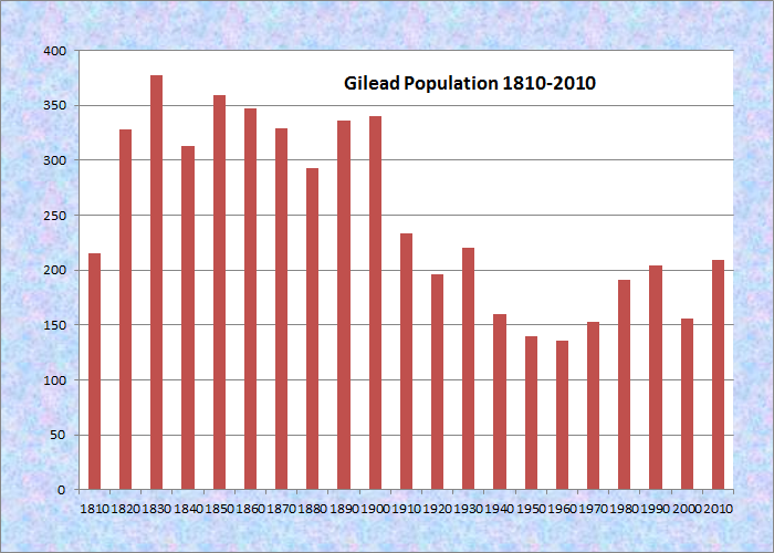
Population Trend 1810-2010
| Geographic Data | |
|---|---|
| N. Latitude | 44:23:56 |
| W. Longitude | 70:56:59 |
| Maine House | District 117 |
| Maine Senate | District 18 |
| Congress | District 2 |
| Area sq. mi. | (total) 19.7 |
| Area sq. mi. | (land) 19.0 |
| Population/sq.mi. | (land) 11.o |
| County: Oxford | |
Total=land+water; Land=land only
[GIL-ee-ahd] a town in Oxford County, incorporated on June 23, 1804 from Peabody’s Grant.

Androscoggin River from the Bridge at Gilead, June, 1973. U.S. EPA. National Archives #NWDNS-412-DA-8215
Settled in 1780, and formerly known as Peabody’s Paten, Gilead welcomes the Androscoggin River as it enters from New Hampshire.
The name comes for the Balm of Gilead tree, a large poplar. According to PlantGuide.org,
The fragrant wax that saturates the winter buds and coats the young leaves in spring gives this tree its name. The bees find it as soon as the sap stirs and the wax softens. Quantities of it are collected and stored in hives “against a rainy day”; for this is what bees use to seal up weather cracks in their hives.
The Androscoggin River splits the town down the middle from west to east, flowing between two mountain ranges. Only one bridge crosses at Gilead Village. During 1973 the U.S. Environmental Protection Agency was documenting pollution in the river.
 N44° 23' 39.99\" W70° 58' 19.55\"")
Picnic Ground (2013) @
The Wild River, also originating in New Hampshire, joins the Androscoggin just west of Gilead Village in the western portion of the town.
Located just north of the Maine segment of the White Mountain National Forest, it has spectacular views of the Presidential Range. A National Forest picnic area is just across the highway from the village community buildings.
 N44° 23' 40.11\" W70° 58' 19.67\"")
On U.S. Route 2 as it enters the state and runs along the river, the town lies just west of Bethel on a rail line. The village itself is at geocoordinates N44° 23′ 40.60; W70° 58′ 20.27.
Launching near Bridge Road off U.S. 2 in Gilead, a relatively brief canoe trip makes about five of its six miles through the town of Gilead to West Bethel. Infrequent Class I rapids are involved; shallows where the river divides around several small islands require one’s attention.
Below, the photo approaching the village was taken on U. S. Route 2 east of the village; the photo leaving was taken west of the village.
 N44° 24' 17.98\" W70° 55' 6.14\"")
Approaching the Village (’13) @
 N44° 23' 39.78\" W70° 58' 19.52\"")
Community Buildings (2013) @
 N44° 23' 40.60\" W70° 58' 20.27\"")
Town Office & Town Hall (’13) @
 N44° 23' 40.05\" W70° 58' 21.50\"")
Train Station (2013) @
 N44° 23' 39.95\" W70° 58' 21.25\"")
Gilead School (2013) @
Some of the community buildings appear to have been assembled on a street parallel to Route 2. The school and train station are not used for those purposes now.
 N44° 23' 40.02\" W70° 58' 19.88\"")
Houses in the Village (2013) @
 N44° 23' 41.37\" W70° 58' 15.93\"")
Fire Department (2013) @
 N44° 23' 35.90\" W70° 58' 31.56\"")
Leaving Gilead (2013) @
Form of Government: Town Meeting-Select Board-Administrative Assistant.
Additional resources
Chapman, George W. Brief History of Gilead, and Prose and Poetic Writings. Portland. Me. The Author. 1867. [University of Maine, Raymond H. Fogler Library, Special Collections; Bethel Historical Society at http://www.bethelhistorical.org/Gilead,%20Maine%20%20Exploring%20Its%20Past.html, accessed December 6, 2011]
Gilead, Maine Bicentennial, 1804-2004: Souvenir Booklet of Early Gilead Photos. Gilead, Me. Gilead Bicentennial Committee. 2004.
*Maine. Historic Preservation Commission. Augusta, Me. Text and black & white photos from National Register of Historic Places: http://pdfhost.focus.nps.gov/docs/nrhp/text/xxxxxxxx.PDF and http://pdfhost.focus.nps.gov/docs/nrhp/photos/xxxxxxxx.PDF
Reiche, Howard C. The Smile of Providence: A History of Gilead, Maine, 1804-2004. Falmouth, Me. Long Point Press. 2004.
Wheeler, Amos. A Tragedy of the Androscoggin: on the Death of Four People, who were drowned in the Androscoggin River, April the 21st, 1803 / by Amos Wheeler. Wild River tragedy: murder, suicide, Charles Freeman of Gilead murdered himself and wife on the morning of June 11th, 1851, the cause was jealousy / by Orrison Drake. Gorham, N.H. Mountaineer Print. 1882.
Willey, Benjamin G. Incidents in White Mountain History: … together with many interesting anecdotes illustrating life in the backwoods. Boston. N.Noyes. Dover, N.H. E. J. Lane. 1856.
National Register of Historic Places – Listings
Gilead Railroad Station, Former
") [Once off Northeast end of Twin Road in Auburn, this small station building has been moved to the town of Gilead] The former Gilead Railroad Station is the oldest train station of Maine’s Grand Trunk Rail line, and the oldest in the State of Maine. Built in 1851 during the construction of the Atlantic and St. Lawrence Railroad, it features the simple design and construction of these early stations. Originally situated beside the tracks in the village of Gilead, it was moved in 1991 to a site in Auburn and rehabilitated.
[Once off Northeast end of Twin Road in Auburn, this small station building has been moved to the town of Gilead] The former Gilead Railroad Station is the oldest train station of Maine’s Grand Trunk Rail line, and the oldest in the State of Maine. Built in 1851 during the construction of the Atlantic and St. Lawrence Railroad, it features the simple design and construction of these early stations. Originally situated beside the tracks in the village of Gilead, it was moved in 1991 to a site in Auburn and rehabilitated.
In 1833 the first railroad charter in Maine was introduced for the Bangor and Piscataquis Railroad and Canal Company. Opening in 1836, it was the first steam railroad in the State. Gilead, like many other Maine towns, prospered during the railroad age. Steam-powered mills producing spool stock, boxes, and staves became fixtures after the appearance of the railroad, and the town developed as a summer vacation retreat near the White Mountains. In 1891, the Wild River Lumber Company had a railroad line that stretched for several miles south of Gilead to the mills in the village of Hastings.
With the decline of the railroads came the demise of the town, and Gilead’s population has declined to its pre-railroad size of some 200 persons. The Gilead railroad station was built by a crew of Atlantic and St. Lawrence Railroad Company carpenters as the line neared the New Hampshire border in 1851. Much of the station, it is believed, was constructed offsite and transported by rail car to Gilead, where it could be quickly erected and pieced together.*
The station was returned to Gilead in 2011.
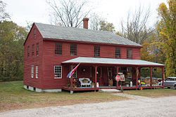
Peabody Tavern
")
[2013] Wikipedia]
[Randy Bennett photo 1976]
[east of Gilead on U.S. Route 2] The Peabody Tavern, built about 1800, was a stage and later a railroad stop between Portland and Lancaster, New Hampshire until the early 20th century. Thomas Peabody, born in Andover, Massachusetts in 1768, was the first owner and member of a prominent family in Gilead. The family had purchased many of the first land rights in what was then called “Peabody Patent.” Thomas’s uncle, Oliver Peabody, had been one of the first settlers in the region in 1781. The patent was probably given to Lieutenant John Peabody, Thomas’s father, who was at the siege and capture of Louisburg in 1758, participated in the taking of Fort Ticonderoga in 1759, and was Captain of a company that marched from Andover to Boston at the news of the Battle of Bunker Hill.
[Randy Bennett photo1976]
Peabody Tavern (1976)
A few yards north of the tavern, the Peabody Cemetery contains the graves of several members of the family including Thomas’s son John. John became a successful lumber manufacturer and served as Justice of the Peace, member of the State Legislature, and Captain in the militia.
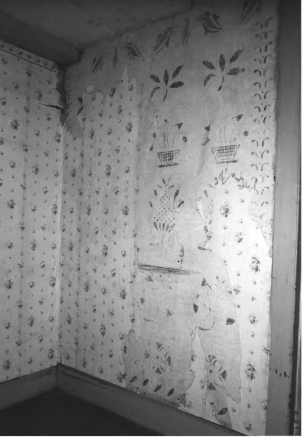
The tavern is a fine structure, hidden in a remote valley in the hills of western Maine, provides an important link with the early years of transportation in the White Mountain region. Its rare wall stenciling (right) is an interesting feature of the interior.*
[Randy Bennett photos, 1976]