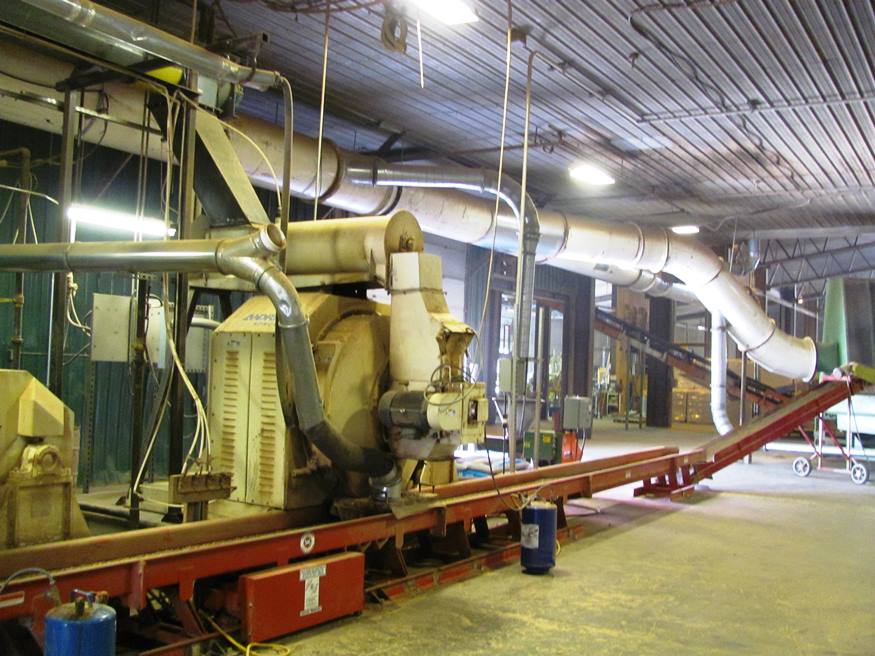
Inside the wood pellet mill in Corinth (2010)

Location Map for Corinth
| Year | Population |
|---|---|
| 1970 | 1,212 |
| 1980 | 1,711 |
| 1990 | 2,177 |
| 2000 | 2,511 |
| 2010 | 2,878 |
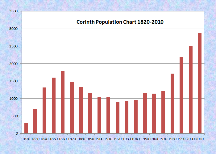
Population Trend 1820-2010
| Geographic Data | |
|---|---|
| N. Latitude | 44:58:48 |
| W. Longitude | 69:00:29 |
| Maine House | District 121 |
| Maine Senate | District 10 |
| Congress | District 2 |
| Area sq. mi. | (total) 40.2 |
| Area sq. mi. | (land) 40.2 |
| Population/sq.mi. | (land) 71.6 |
County: Penobscot
Total=land+water; Land=land only |
|
[KOR-inth] is a town in Penobscot County, incorporated on June 21, 1811 from the former township T2 R4 NWP.
The area, previously known as New Ohio and Ohio, was settled by Abner Tibbetts in 1794 soon to be followed by others. The earliest village was near the current village of West Corinth and is known as the Skinner Settlement after the family that arrived in 1793.
") Nineteenth century Republican Governor Daniel F. Davis, who was seated after a disputed election, made Corinth his home town.
Nineteenth century Republican Governor Daniel F. Davis, who was seated after a disputed election, made Corinth his home town.
George Varney recorded the early manufacturing base of the town in 1886:
There are three saw-mills manufacturing long lumber, three shingle, one stave, two planeing and two grist mills, one cheese-factory, one carriage and sleigh factory.
 N44° 59' 50.33\" W69° 1' 13.00\"")
Central High School in East Corinth Village (’14) @
In the late 19th century, the town of Corinth had thirteen public school houses with a local population, in 1880 of 1,333.
 in East Corinth (2014) N45° 0' 57.73\" W69° 1' 21.93\"")
Countryside Restaurant (2014)@
Though the population is well dispersed, the main village of East Corinth sits at the junctions of Maine Routes 11, 15, and 43 in the north central area of the township. South Corinth and West Corinth are located as their names imply. Robyville village is in the extreme south of the town. There is no Corinth village.
The town has more than doubled in population since 1970, and increased 15 percent from 2000-2010.
In the twentieth century, the manufacturing base gradually dwindled as technology and cheap labor elsewhere had its effect.
Recently, the Corinth Wood Pellets mill has taken advantage of this new form of heating fuel, turning wood chips into pellets.
Its complex, computer controlled facility has provided jobs in an area where traditional employment has declined.
")
Wood Pellet Mill Equipment (2010)
")
Wood Chips to be Processed (2010)
 N45° 0' 8.93\" W69° 1' 22.62\"")
Town Hall and Corinthian Lodge (2014) @
 N45° 0' 22.56\" W69° 1' 28.93\"")
United Methodist Church in East Corinth (’14) @
The town was home to Arthur R. Gould, a major force behind the development of Aroostook County and a U.S. Senator.
 N45° 0' 22.54\" W69° 1' 28.82\"")
Corinth Post Office in East Corinth Village (’14) @
 N45° 0' 8.73\" W69° 1' 22.67\"")
Corinth Baptist Church in East Corinth (’14) @
Form of Government: Town Meeting-Select Board-Manager.
Additional resources
Attwood, Stanley Bearce. The Length and Breadth of Maine. Orono: University of Maine Press. 1977. p. 130.
Chadbourne, Ava Harriet. Maine Place Names and The Peopling of its Towns.
Hall. Oliver L. The Man From East Corinth: Episodes in the Life of Arthur R. Gould, A Builder of Aroostook and Senator of the United States. Augusta, Me. Kennebec Journal Print Shop. 1941.
Maine. Historic Preservation Commission. Augusta, Me. Text and photos from National Register of Historic Places.
Varney, George J. A Gazetteer of the State of Maine. 1886. p. 181.
National Register of Historic Places – Listings
Corinth Town Hall and Corinthian Lodge #59, I.O.O.F.
[328 Main Street] The Corinth Town Hail and Corinthian Lodge #59, I. O. O. F is a substantial, architecturally notable two story structure located on Main Street in the Penobscot County village of East Corinth. [See photo above left] Built jointly by the Lodge and the Town in 1880, the handsome Italianate style building with Stick Style details served as the site of Corinth government and as the meeting hall for the fraternal organization into the 1980s. It was also an important public hall, a site for entertainment and recreation throughout its history.
East Corinth is one of two principal villages in Corinth and throughout the 19th century was the center of business for the town. In March 1880 the town meeting voted to build a new town hall in partnership with the Lodge.
The Town Hall and Corinthian Lodge building is notable both as a good example of Italianate and Stick Style architecture and as one of the very few buildings that survived a series of major fires in 1899, 1907 and 1914. It is one of the oldest non-residential buildings in town.*
Skinner Settlement, West Corinth Village
[3.5 miles West of East Corinth] Daniel Skinner arrived in 1793 with his grown sons, Asahel and Elijah and four other children. They cleared the area for a farm and built a log cabin across the road from the present 1810-1815 farmhouse. In 1805 Daniel and Asahel acquired 200 acres, including the 50 acre homestead and adjacent land. Daniel and Elijah farmed and kept a tavern, living first in the log house and later in the farmhouse, apparently the first, or one of the first, frame houses in the settlement.
The 40′ x 60’ barn, built by Royal A. Sweet in 1873, replaced two smaller barns. Sweet, a local blacksmith and wagon maker, also built the nearby Robyville covered bridge. The farmstead buildings are representative of the attached house-ell-barn architecture in rural Maine after the Civil War.
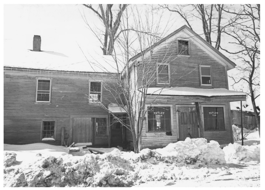
Hodson General Store (1973)
 Maine Historic Preservation Commission photo")
Methodist Meeting House (1973)
George Skinner, son of Elijah, brought the farm to its highest degree of cultivation from 1850 to the early 1900s. The farm had remained in the Skinner family to at least the 1970s. With only minor changes the farmstead was, in 1973, a good example of an inland Maine farm as it had evolved by the second generation after settlement.* [Richard D. Kelly photos, 1973]
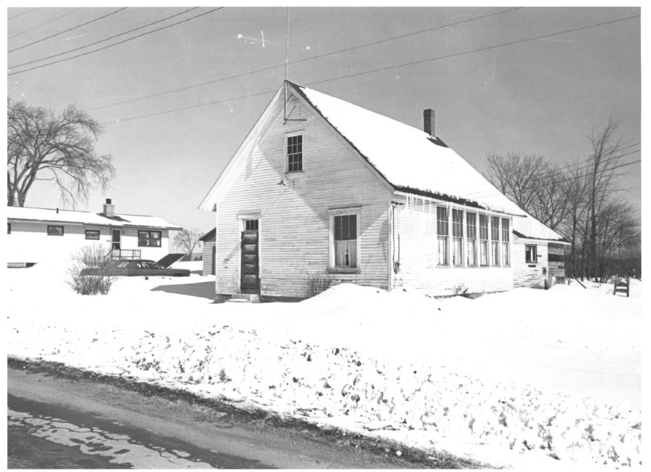
Dist. #2 School House (1973)
However, the Skinner Homestead Association, seeking to preserve the Homestead, has apparently been dissolved, buildings have deteriorated or have been demolished.
Other Historic Register buildings are nearby in the West Corinth village area.
Robyville Bridge
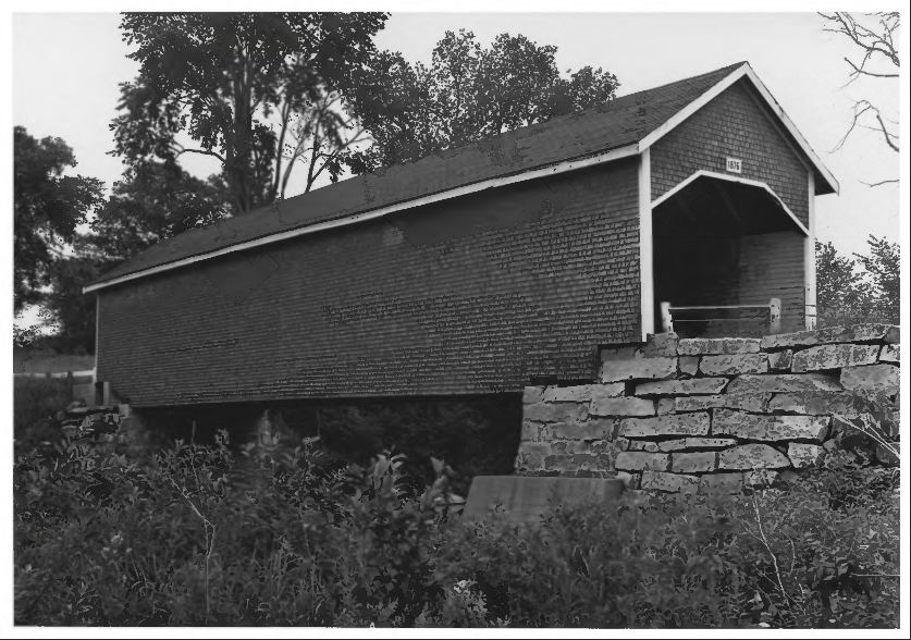
Robyville Covered Bridge (1970)
[over Kenduskeag Stream, Robyville] The Robieville or Robyville section of Corinth was once the site of saw mills. No doubt many bridges have previously occupied the site of this 1876 bridge, built following the “Howe Truss” design, with some variations. It is one of only a few covered bridges remaining in the state.
The bridge, reinforced by the Maine Department of Transportation in 1994, was designated a Maine Historic Civil Engineering Landmark in 2002. It is located 3/4 of a mile northwest of Kenduskeag village near the Grant Road in West Corinth.* [Maine Park and Recreation Commission photo]