St. George

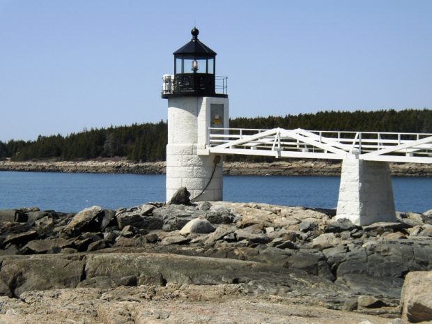
In a park near the town office, St. George and the dragon reenact their famous battle. See photos. The Fort St. George’s memorial is nearby.St. George was the site of granite quarries and was the birthplace of the Granite Cutters Union in 1877, the first in the state’s history. The town may be better known by some by its villages of Port Clyde, at the southern tip of its long peninsular, and Tenants Harbor.

St. Francis

St. Francis down the St. John River from Allagash (2003

The St. Francis River, which forms the northeastern border with Canada along with the St. John River, joins the St. John at the town of St. Francis. Across the St. John lies Madawaska County, New Brunswick. The St. John River forms the northern boundary of this small community, which has been declining in population for the past two decades. It is the last organized town on Route 161, which follows the St. John River from Fort Kent.

Stacyville

Mount Katahdin and Hunt Mountain from Swift Brook Road in Stacyville (2017)

Its main village is Sherman Station on the Bangor and Aroostook Railroad line and Maine Route 11 just across the town line from the Town of Sherman. Stacyville Village is in the southwest of the township; Siberia village is in the center on the Grindstone Road. That portion of Route 11 in Sherman Station Village serves as the “Main Street” for the town, with community buildings and businesses.

Springfield

Wind Turbines on Rollins Mountain from Weatherby Hill on Route 6 in Springfield (2014)

Located on the east-west Maine Route 6 crossing eastern Penobscot and northern Washington counties, the town has a substantial area in wetlands. See photos. One account has the name commemorating “extensive fields abounding in springs.” The village is centered around the crossroads of Route 6, Park Street (Routes 169/170), and Shep Road.

Sprague, Peleg

Peleg Sprague

(1793-1880), grandfather of Charles Franklin Sprague (a U.S Representative from Massachusetts 1897-1901), was a himself a Representative and a U. S. Senator from Maine Charles Sprague was born in Duxbury, Massachusetts on April 27, 1793. He graduated from Harvard University in 1812, studied law at Litchfield, Connecticut, was admitted to the bar in 1815 and…

Spotted Elk, Molly

Molly Spotted Elk

1903 Born on Indian Island, eldest child of Horace Nelson, a future Penobscot Governor, and Philomena Solis Nelson, a celebrated basket maker. In Penobscot her given name is “Molly Dellis.” After her mother’s early death, Molly raises her seven brothers and sisters; studies native dancing to support her family. 1920-1922 (ca.) Studies anthropology and native…

Sports Championships

Baseball Basketball, Boys Basketball, Girls Cheerleading Cross Country, Boys Cross Country, Girls Diving Field Hockey Football Golf Gymnastics Hockey Lacrosse Skiing, Boys Skiing, Girls Soccer, Boys Soccer, Girls Softball Swimming Tennis, Boys Tennis, Girls Track, Outdoor, Boys Track, Outdoor, Girls Track, Indoor, Boys Track, Indoor, Girls Volleyball Wrestling The Maine Principals Association supervises interscholastic sports.…

Species, Endangered and Threatened

Eagles Nest Distribution 2008

Since European settlement, at least 14 species of wildlife are known to have been completely eliminated from the Maine environment. To prevent further losses, the Maine Endangered Species Act was enacted in 1975. In 1986, Maine’s first list of 23 Endangered and Threatened species was adopted. After the Maine Department of Inland Fisheries and Wildlife…

Southwest Harbor

Location Map for Southwest Harbor

It lies on the southwest entrance to Somes Sound, diagonally across from Northeast Harbor, a village in the town of Mount Desert. Southwest Harbor has been both a fishing and summer resort community from its earliest days as a town. See photos. Maine Route 102 begins at entrance to Mount Desert Island and leads directly south to the main village of Southwest Harbor. Here the Wendell Gilley Museum celebrates the life and work of Gilley, a pioneer of decorative bird carving. South of the harbor, the small villages of Manset and Seawall face the entrance to Somes Sound and the Cranberry Isles.

South Thomaston

The town lies on the Weskeag River, which broadens into several large coves before emptying into the Muscle Ridge Channel. In addition to the main village, Pleasant Beach, Waterman Beach, and Spruce Head villages hug the shore on Penobscot Bay. Spruce Head Island, connected to the mainland by a bridge, juts into Muscle Ridge Channel, a favorite passage for boaters seeking the protection of the outlying islands.

South Bristol

Boats and Osier

The Darling Marine Center of the University of Maine is located in the village of Walpole. See photos. The population centers in the town’s southern most reaches are on Rutherford Island, perched at the end of a peninsular. The community is home to three nature preserves. Plummer Point is a 74 acre wooded peninsula with over a mile of shoreline. The Tracy Property is a town park with public access to the Damariscotta River. The wooded 18-acre Witch Island Sanctuary, provides two beaches and views of Johns Bay.

South Berwick

Counting House Day Lily Memorial Park at the Salmon Falls River (2018)

Maine’s oldest educational institution, Berwick Academy, was established here in 1791 when the town was part of Berwick. See photos. South Berwick is the birthplace of Sarah Orne Jewett, who attended Berwick Academy for four years — her only formal education. The town is accessible to the coastal communities of York and Kittery via Maine Routes 91 and 236.

Sorrento

Sorrento Harbor (2004)

Sorrento sits on Waukeag Neck, on Maine Route 185 south of Sullivan. See photos. The neck juts into Frenchman’s Bay with spectacular views of the mountains in Acadia National Park. Sorrento Harbor is a centerpiece of the community, especially when the “summer people” return and the water fills with pleasure boats. The town hosts two nature preserves in Sorrento Harbor, both maintained by the Nature Conservancy: Dram Island, is home to nesting osprey; Preble Island is densely forested with eagles roosting.

Somes, Daniel E.

Daniel Elton Somes (1815-1888) a U.S. Representative was born in Meredith (now Laconia), New Hampshire on May 20, 1815 where he received an academic education. Somes moved to Biddeford in 1846 and established the Eastern Journal, later known as the Union and Journal; and engaged in the manufacture of loom harnesses, reed twine, and varnishes.…

Somerville

School and Town Office (2003)

The Sheepscot River runs through the western portion of the town, and through Somerville Village itself. It widens into Long Pond (once known as Patricktown Pond), on which the town has substantial frontage. See photos. Somerville is east of Windsor on Maine Route 105, and north of Jefferson following Maine Route 206 to 105. This rural town has had a small, but growing population. Since the 1970’s it has grown to two and a half times its size then.

Solon

Interior of South Solon Meeting House, 121 South Main Street in Solon (2003)

Solon, Maine is a town in Somerset County, incorporated on February 23, 1809 from the township T1 R2 EKR. Settled in 1782 by William Hilton of Wiscasset, it was named for one of the great sages of Ancient Greece, in keeping with its neighboring town of Athens.

Softball

Softball Image public domain

Consecutive Champions School No. Year Madison 4 1994-1997 Traip 3 1988-1990 Jonesport-Beals 3 1992-1994 Richmond 4 2013-2016 Year Class A Class B Class C Class D 1977 Winslow Hermon Massabesic 1978 Mt. Ararat Gorham Searsport 1979 Winslow Massabesic Madison 1980 Gardiner Van Buren York 1981 Westbrook Gorham Mexico 1982 Houlton Lisbon Mexico 1983 Cony Gorham…

Soccer, Girls

Consecutive Championships School No. Year North Yarmouth 5 2003-2007 Year No Class Class B Class C Class D 1980 Waterville 1981 Waterville Class A 1982 Waterville Hyde 1983 Waterville Penobscot Valley 1984 Waterville Penquis Valley 1985 Mount Ararat Penobscot Valley 1986 Caribou Penobscot Valley 1987 Mount Ararat Houlton Carrabec 1988 Cape Elizabeth York Schenck 1989…