")

Location Map for Wallagrass
| Year | Population |
|---|---|
| 1970 | 617 |
| 1980 | 653 |
| 1990 | 582 |
| 2000 | 561 |
| 2010 | 546 |
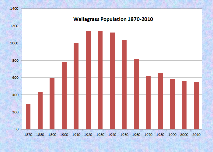
Population Trend 1870-2010
| Geographic Data | |
|---|---|
| N. Latitude | 47:08:48 |
| W. Longitude | 68:37:40 |
| Maine House | District 151 |
| Maine Senate | District 1 |
| Congress | District 2 |
| Area sq. mi. | (total) 40.5 |
| Area sq. mi. | (land) 39.8 |
| Population/sq.mi. | (land) 13.7 |
County: Aroostook
Total=land+water; Land=land only |
|
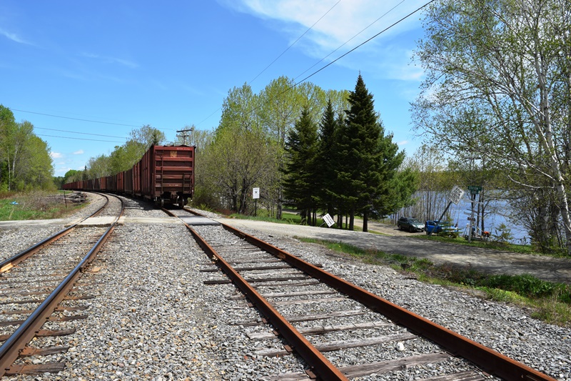
Wallagrass Station (2018)
Fish River at Soldier Pond Village in Wallagrass (2018)
[wall-ah-GRASS] is a town in Aroostook County, incorporated on June 4, 1979 from Wallagrass Plantation, once known as Hancock Plantation.
Settled by Acadians, the town lies just south of Fort Kent on the Fish River, whose Eagle Lake outlet is in the southern portion of the township.
In the 1880’s Wallagrass had a population of 431 supporting three public schoolhouses. Having recovered population in the 20th century, it has consistently declined since 1980.
")
")
The Lake at Station Road
Soldier Pond, named after the bloodless Aroostook War, is a bulge in the Fish River. The Bangor and Aroostook Railroad hugs the west bank of the river and Eagle Lake from the town of Eagle Lake to Fort Kent.
Wallagrass has two small villages, each with a small cluster of buildings. Most residents, however, are scattered throughout town on farms and single-family lots. The town has evolved into a bedroom community for people who work in the surrounding larger communities with a growing number of residents conducting full or part-time businesses from their homes.
")
House on Eagle Lake (2018)
Wallagrass Station village is located at the southern end of the town, where Station Road leads to the shore of Eagle Lake. The shore here hosts several modest houses that enjoy the lake.
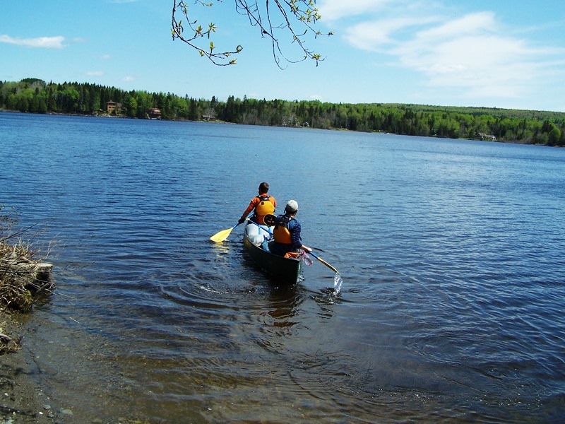
It also has been a launching spot for a canoe trip down the Fish River on a northerly paddle, passing through Soldier Pond Village in Wallagrass.
Portaging around Fish River Falls in southern Fort Kent is necessary arrive at the takeout in Fort Kent village.
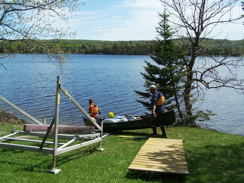
Canoe Launch (2018)
Off the Launch (2018)
")
On the Lake (2018)
Soldier Pond Village (not related to Soldier Pond in Soldiertown Township in Penobscot County) is located about three miles north of Wallagrass Station in Wallagrass. The small village has a boat launch on the Fish River, a school, veterans memorial, church, post office and several houses along the river, and a grand house near the church.
")
Grand House (2018)
")
Elementary School (2018)
")
Catholic Church (2018)
")
Boat Launch (2018)
")
Soldier Pond Village (2018)
The 2008 Comprehensive Plan offers these insights [edited and condensed]:
The land is mostly hilly and wooded with scenic views and numerous streams feeding into the Fish River. The residents are interested in conserving the rural quality of life and in preserving the local cultural heritage and history. Although the population has become more diverse ethnically, the French culture remains strong.
There is a rich agricultural and forestry heritage, a range of cultural and historical resources, the promise of future small business development, a well developed and maintained trail system, quality water and air, a diversity of religious denominations, and accessible medical and emergency services.
Wallagrass Stream was once a producer of electric power at the Albert Michaud Dam. The power generated was supplementing the need for electricity in the Fort Kent area beginning in 1912.
There were several sawmills in town. One was in Soldier Pond, first owned by Nelson and later by Daigle & Sons, who were forced to close down during the Depression. Another was at Labbe Pond—it also folded in the Depression years. Some of the gravel pits in town have been in operation for several generations. There were also mills located on the Michaud Road, a sawmill along the Fish River near the present Sutton Siding Road, and a mill near the Carter Brook Tote Road.
Four schools were originally located in the town, two of which are still standing. One was a Boarding School located at the Convent in Wallagrass.
Form of Government: Town Meeting-Select Board-Manager.
Additional resources
A Comprehensive Plan for the Town of Wallagrass. July 2008. http://www.maine.gov/spo/landuse/compplans/plans/wallagrass/WallagrassCP2008.pdf (accessed April 24, 2012)
Stadig, Rita B. Rita Stadig Collection, 1900-2009. (Cataloger Note: A variety of papers and photographs pertaining to the Stadig family and the history of the St. John Valley. The materials cover topics such as the lumber industry, Sweden and the Swedish colony of Aroostook County, World War II and the Fish River; Fort Kent, Wallagrass, and Madawaska are also represented by items in the collection.) [University of Maine at Fort Kent, Blake Library]
Wallagrass Comprehensive Plan, July 1986. Wallagrass, Me. Planning Board. 1986. [University of Maine, Raymond H. Fogler Library, Special Collections]
Wilson, Richard Edward. The Labbes of Wallagrass and Brunswick, Maine: A Study in Landscape, Community, and Family. Brunswick, Me. Richard Edward Wilson. 1997. (Thesis (MA)–Vermont College of Norwich University, 1997.) [University of Maine at Fort Kent, Blake Library]
National Register of Historic Places – Listings
Photos, and edited text are from nominations to the National Register of Historic Places researched by Maine. Historic Preservation Commission.
Full text and photos are at https://npgallery.nps.gov/nrhp
Freeman Barn
The Freeman barn is a Gothic arched bank barn, built about 1925, facing east on Route 11 and overlooking the Fish River. The 49 x 73 barn sits on a 4.4 acre lot with hay fields of the original farm to the west. The barn sits at the edge of the abrupt transition from cleared farm land along Route 11 to thick forest to the west. Wallagrass is on the edge of the larger Aroostook County potato production areas.
The Freeman barn is an example of an innovative barn architecture that is becoming rare nationwide and particularly in northern Maine. The Gothic arch roof is an engineered solution to provide maximum volume for hay storage for a given floor area. The graceful curve and the voluminous loft create a distinctive architectural form. However, the form quickly becomes obsolete with the shift in farming patterns after the introduction of gasoline powered tractors and a shift to other methods of hay storage.
Aroostook County farming from its beginning was diverse and required large flexible barns to provide shelter from the harsh winter for the varied harvested crops and animals. With the coming of railroad access, potato farming became a central focus in the county. The bank barn configuration and Gothic arch roof reflects accommodation for the overwhelming importance of potato farming while at the same time addressing the continued importance of hay storage and a mix of other crops and animal husbandry required to be profitable and self-sufficient through the harsh winters. The period of significance is from the barns construction c. 1925 to Active farm use of the barn continued until at least 1966.
My Pepe, Levy Michaud, grew up on the farm at the intersection of rt 11 and Michaud Farm rd.
My grandmother Ozety Michaud Boyle was born sept.25 1881 in Wallagrass her great grandfather Romaine Michaud was the first to settle there he was Québecois.